New research has shown that Roman activity across Scotland was more significant than previously thought.
As the map below demonstrates, the force reached far and wide, setting up camps as far north as Elgin, and to the west near Stranraer, as well as at widely known sites along the Antonine Wall.
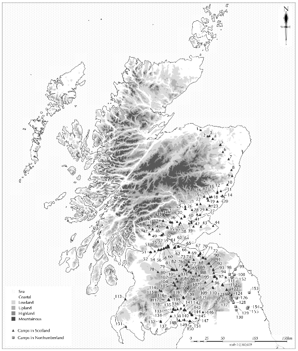
The map and key below (listing the camp names) have been compiled by Dr Rebecca Jones, an archaeologist with the Royal Commission on Ancient and Historical Monuments, who used photographs from the organisation's aerial survey collection, as well as existing archives, to record every site in Scotland, which is home to the largest number of surviving Roman camps in Europe.

"For the first time, we have a picture of the true extent of the Roman war machine in Scotland," says Dr Jones. "By mapping and recording the hundreds of temporary army outposts, we have provided an important benchmark for further research into the northernmost frontier of the Roman Empire."
Up to 260 camps have now been discovered in Scotland - in some cases several were set up close together or at the same site.
Although the camps provided only basic accommodation for soldiers and were not occupied for long, they were crucial to the Roman campaign in Scotland, housing the army when on patrols or manoeuvres.
Their shapes can be detected through techniques such as the study of crop patterns on aerial photographs, which can indicate the outlines of ancient structures.The photographs in the gallery above show the locations of some of the Roman camps today, and a selection of artefacts recovered from sites across Scotland, now displayed in The Hunterian, at the University of Glasgow.
Dr Jones provides a full archaeological record of these military outposts in her new book Roman Camps in Scotland.


Why are you making commenting on The Herald only available to subscribers?
It should have been a safe space for informed debate, somewhere for readers to discuss issues around the biggest stories of the day, but all too often the below the line comments on most websites have become bogged down by off-topic discussions and abuse.
heraldscotland.com is tackling this problem by allowing only subscribers to comment.
We are doing this to improve the experience for our loyal readers and we believe it will reduce the ability of trolls and troublemakers, who occasionally find their way onto our site, to abuse our journalists and readers. We also hope it will help the comments section fulfil its promise as a part of Scotland's conversation with itself.
We are lucky at The Herald. We are read by an informed, educated readership who can add their knowledge and insights to our stories.
That is invaluable.
We are making the subscriber-only change to support our valued readers, who tell us they don't want the site cluttered up with irrelevant comments, untruths and abuse.
In the past, the journalist’s job was to collect and distribute information to the audience. Technology means that readers can shape a discussion. We look forward to hearing from you on heraldscotland.com
Comments & Moderation
Readers’ comments: You are personally liable for the content of any comments you upload to this website, so please act responsibly. We do not pre-moderate or monitor readers’ comments appearing on our websites, but we do post-moderate in response to complaints we receive or otherwise when a potential problem comes to our attention. You can make a complaint by using the ‘report this post’ link . We may then apply our discretion under the user terms to amend or delete comments.
Post moderation is undertaken full-time 9am-6pm on weekdays, and on a part-time basis outwith those hours.
Read the rules hereComments are closed on this article