

Location: Fraochaidh, Argyll
Grade: Long mountain walk
Distance: 12 miles/20km
Time: 6-8 hours
WALKING past Ballachulish’s primary school I was accosted by a young lad, no more than six or seven years old, who demanded to know where I was going? “I’m going to climb a mountain,” I replied. “You’re going to climb a mountain,” the youngster repeated, “Why?”
I mumbled some sort of answer about needing the exercise and hoping to get a good view but the directness of the question had taken me by surprise. The previous two days had been incredibly wet and windy and as I left Ballachulish behind and climbed up the muddy footpath above the roaring waters of the River Laroch I knew I was in for a day of gusty, wet showers and very wet underfoot conditions. The wee schoolboy’s question suddenly seemed very relevant.
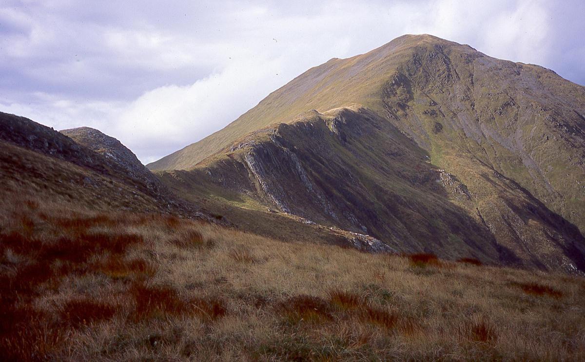
I was heading for Fraochaidh (try free-achy), at 2884ft/879m a big, bold hill that hides itself away between Glen Creran and the double-topped massif of Beinn a’ Bheithir. Protected by huge conifer plantations, the options for accessing the mountain are rather limited and while it’s possible to climb the hill from other directions the route from Ballachulish, via the old right of way between Loch Leven and Loch Creran, gives the best conifer-free choice.
The hill’s name translates to ‘heathery hill’ but I knew from previous experience that its slopes were more grassy than heathery and were invariably wet and boggy. After two days of very heavy rain the surrounding hillsides had sprouted a thousand new streams, wriggling down the slopes like long white worms. The ascent of Fraochaidh, I knew, was going to be a real bog-trot.
Ahead of me a long ridge rose up to the east summit of Sgorr Dhearg of Beinn a’ Bheithir and the sun, breaking out momentarily from the dark clouds, suddenly lit the upper crags of the ridge. For a fleeting moment I wished I was going up there, up the long and rocky ridge to familiar peaks and comparatively dry underfoot conditions. But I had left a note at home saying I was going to Fraochaidh – so folk would know where to look for me in the event of an accident, the insurance policy of the solo mountain walker. I ignored the mild temptation to change my plans.
The day, as so often happens, turned out better than I expected. I met a hill fox on the path in Gleann an Fhiodh – he stopped, sniffed the air then bolted off in a blur of rusty gold. The Glen Creran right-of-way path wasn’t as wet and nasty as I remembered it and the undulating high-level ridge walk round to the rocky summit slopes of Fraochaidh, although wind-blasted, gave wonderful views of the glorious jumble of big hills all around – the serrated crest of the Aonach Eagach ridge giving way to the rounded cone of the Pap of Glencoe, the Pap’s closer, mirror-image Sgorr a’ Choise, the huge bulk of Bidean nam Bian, its neighbour Sgor na h-Ulaidh, Beinn Fhionnlaidh, Beinn Sgulaird and closer at hand, the bare backside of Beinn a’ Bheithir.
As I finally crossed the broad summit ridge to the cairn the reasons why I climb mountains suddenly swamped me in a flow of emotion. It was a combination of endorphin rush mixed with notions of freedom, the insignificance of man against the more lasting realities of these ancient glens and hills and the simple, child-like pleasure in being up high, with an eagle’s-eye view of the watery west laid out below.
Away below me the fjord-like Loch Creran squeezed its way out into Loch Linnhe and beyond the island of Lismore the hills of Mull lay pale on the horizon. As I rested against the stones of the summit cairn I half hoped I would meet the young schoolboy again on my return to Ballachulish. I’d be better able to answer his question now.
Cameron McNeish
ROUTE PLANNER
Map: OS 1:50,000 Landranger sheet 41 (Ben Nevis); Harveys 1:40,000 British Mountain Map, Ben Nevis & Glen Coe
Distance: 12 miles/20km
Time: 6-8 hours
Start/finish: West Laroch, Ballachulish (GR: NN080580)
Public transport: Regular bus services to Ballachulish from Fort William and Glasgow. See www.travelinescotland.com
Information: Fort William TIC, 01397 701801
Route: Start from the minor road from West Laroch that runs up beside the Ballachulish Primary School. Go through a farmyard, through two gates and continue on the track that soon becomes a muddy footpath. After about 3km look out for a cairn on a hillock on your right and shortly after this cairn the path divides at a stream. Take the left path down to the River Laroch and follow the bank until you spot a cairn on the opposite bank. This cairn indicates the right of way to Glen Creran. Cross the river and follow this path uphill to the forestry fence before turning right along the ridge crest to ascend the first top of the long, curved ridge that eventually leads to the summit of Fraochaidh. Return the same way.


Why are you making commenting on The Herald only available to subscribers?
It should have been a safe space for informed debate, somewhere for readers to discuss issues around the biggest stories of the day, but all too often the below the line comments on most websites have become bogged down by off-topic discussions and abuse.
heraldscotland.com is tackling this problem by allowing only subscribers to comment.
We are doing this to improve the experience for our loyal readers and we believe it will reduce the ability of trolls and troublemakers, who occasionally find their way onto our site, to abuse our journalists and readers. We also hope it will help the comments section fulfil its promise as a part of Scotland's conversation with itself.
We are lucky at The Herald. We are read by an informed, educated readership who can add their knowledge and insights to our stories.
That is invaluable.
We are making the subscriber-only change to support our valued readers, who tell us they don't want the site cluttered up with irrelevant comments, untruths and abuse.
In the past, the journalist’s job was to collect and distribute information to the audience. Technology means that readers can shape a discussion. We look forward to hearing from you on heraldscotland.com
Comments & Moderation
Readers’ comments: You are personally liable for the content of any comments you upload to this website, so please act responsibly. We do not pre-moderate or monitor readers’ comments appearing on our websites, but we do post-moderate in response to complaints we receive or otherwise when a potential problem comes to our attention. You can make a complaint by using the ‘report this post’ link . We may then apply our discretion under the user terms to amend or delete comments.
Post moderation is undertaken full-time 9am-6pm on weekdays, and on a part-time basis outwith those hours.
Read the rules here