
Location: Creag a’ Mhadaidh
Perthshire
Grade: Moderate hill walk
Distance: 10.5 miles/18km
Time: 5-6 hours
IT’S not unusual for people to ask me what I’ll do once I’ve climbed all of Scotland’s hills and mountains. I usually just suggest I’ll climb them all again. You can’t get too much of a good thing.
But even those who have climbed Scotland’s Munros several times over still find new ways to climb the hills and in doing so enjoy a completely different experience. It’s fair to say that most of the normal routes to the top of the Munros are the easiest and most straightforward routes and not always the best or most interesting routes. So there’s still plenty to do.
I also enjoy visiting areas that might not contain any Munros or Corbetts and I’m constantly surprised by the quality of views on offer from some of the smaller hills. A good example is Creag a’ Mhadaidh, the rock of the fox, that sits close to the old through-route between Annat on Loch Rannoch and Dalnaspidal near Drumochter.
These old routes have been walked by generations of people, drovers and shepherds, soldiers and navvies, poets and philosophers and sometimes it’s good to be reminded of that, especially in areas that are otherwise isolated and remote. An additional surprise to the through-route from Rannoch to Dalnaspidal is the amount of industrial heritage that’s around.
Here is a land that has been heavily used for hydro-power and yet other than the odd track or small dam there is very little that appreciably despoils the landscape. I’m well aware that hydro-power has, in some areas, had a devastating effect on the landscape but compared with the in-your-face obtrusiveness of windfarms, so conspicuous from dozens of miles around, then hydro-power could almost be described as ‘sensitive.’
Loch Rannoch, at the start of this walk, is part of the huge Rannoch-Tummel hydro catchment area that uses a ribbon of lochs that begin where the fast-flowing Garbh Ghaour leaves Loch Laidon on the Rannoch Moor. Loch Eigheach is the next loch in the chain, 178 feet higher than Loch Rannoch. Next comes Loch Dunalastair, then Tummel, then Loch Faskally before the River Tummel eventually flows into the Tay on its journey to Perth and Dundee. The remarkable thing about this system of lochs and rivers is that the source of it all, on the Rannoch Moor, is only a few miles from the Atlantic! We live in a country that definitely leans to the west.
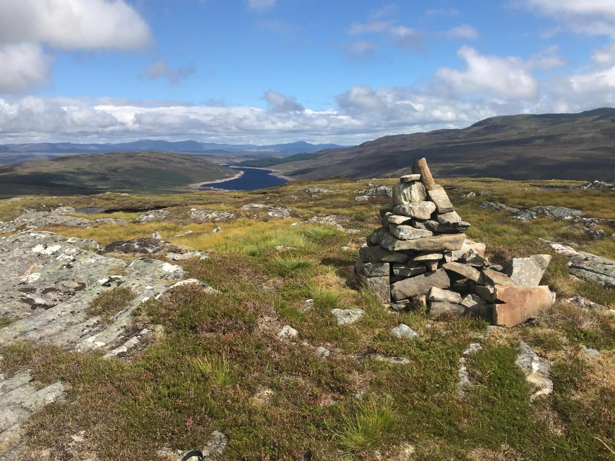
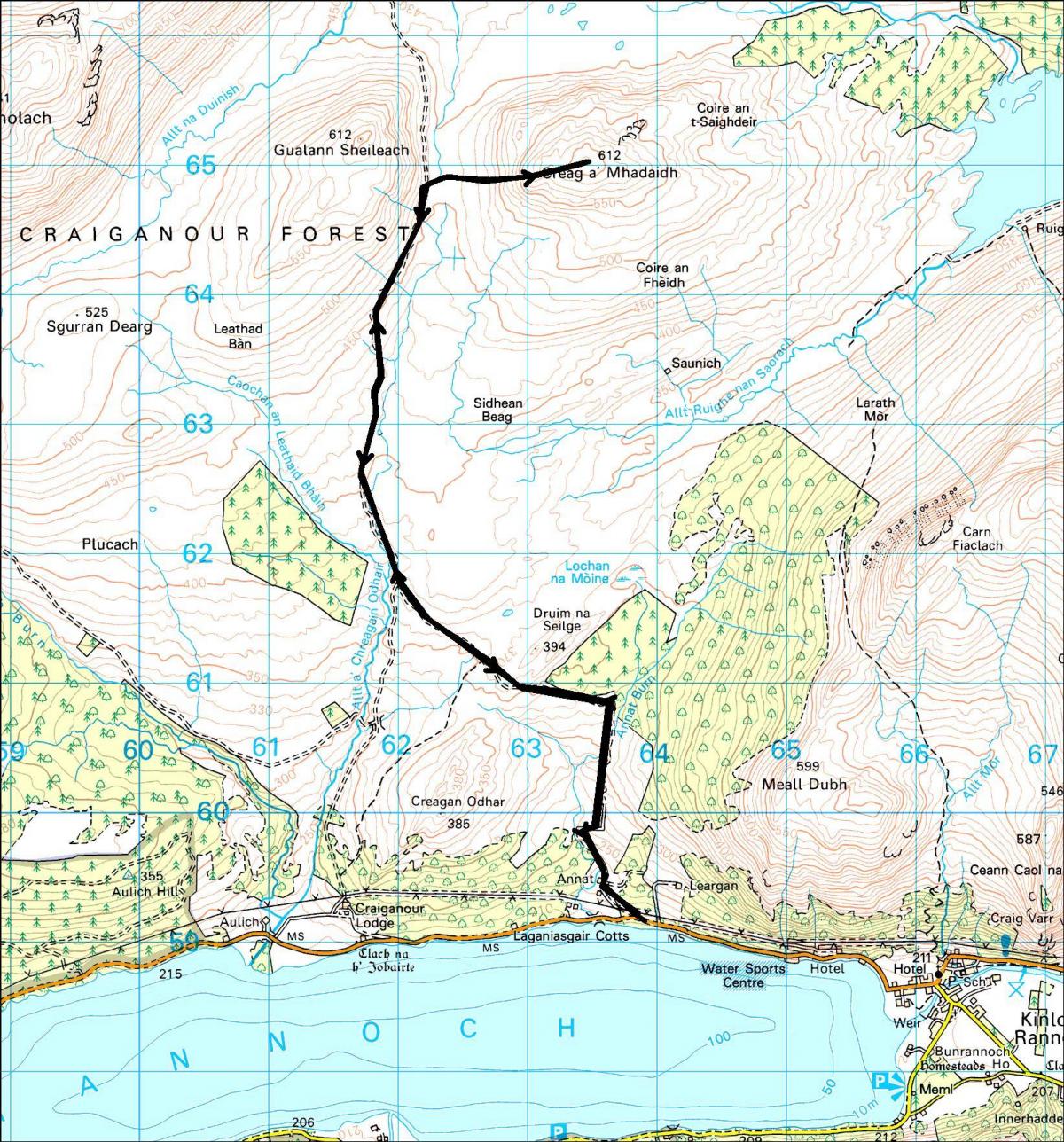
At 612 metres, Creag a’Mhadaidh lies in the middle of the Craiganour deer forest, a region of wide open, deer-haunted moors and long views. There are two choices for starting points – the most direct runs through the policies of Craiganour Lodge but if you don’t like the idea of hiking up the long driveway to the big house you can begin a couple of kilometres to the east at Annat on Loch Rannoch-side. A Scottish Rights of Way signpost points the direction of the through route to Dalnaspidal and the path quickly climbs to the open moor beyond the woods of the Annat Burn.
It was about here I became aware that autumn was in the air. A great herd of red deer hinds crossed the track in front of me and I later hear some roaring from the stags. A gaggle of geese flew high overhead and the ground was already turning gold.
Behind me, the snow dusted tops of the Carn Mairg hills, beyond the Black Wood of Rannoch, and Schiehallion reminded me that winter had already arrived on the high tops, although the hills in front of me, the Corbetts of the Talla Bheithe forest and Drumochter, were snow-free.
The right of way climbs gently up to a pass between Gualann Sheileach and Creag a’Mhadaidh itself, before dropping down to the bothy at Duinish and Loch Garry. From the high point I took to the soggy slopes and climbed easily to the wide summit of Creag a’Mhadaidh, deliberately picking out the steepest line I could find amongst the broken crags. Even that posed little difficulty.
A cold wind was scourging the summit and I didn’t want to linger, despite the long views to the east across the man-made Loch Errochty to the big mountains of Atholl, and just as I was about to descend I saw a little bird that convinced me that autumn was not yet fully gone. It was a wheatear, its white rump flashing in the light, and probably just about to depart for its long journey to its African winter. That was enough to set me off in good spirits all the way back to Loch Rannoch.
Cameron McNeish
Map: OS 1:50,000 Landranger sheet 42 (Loch Rannoch & Glen Garry)
Distance: 10.5 miles/18km
Time: 5-6 hours
Start/Finish: Annat on the B846 Loch Rannoch road (GR: NN638592).
Transport: None to the start.
Route: Leave the road by the Scottish Rights of Way sign and follow the path N, initially past some woodland. Cross the Annat Burn and head W then NW onto the open moor to meet the track running N from Craiganour Lodge. Follow the track N to the high point between Gualann Sheileach and Creag a’Mhadaidh. Leave the track here and head E, climbing steepening ground to work through a cluster of broken crags to the summit slopes. Return by the same route.


Why are you making commenting on The Herald only available to subscribers?
It should have been a safe space for informed debate, somewhere for readers to discuss issues around the biggest stories of the day, but all too often the below the line comments on most websites have become bogged down by off-topic discussions and abuse.
heraldscotland.com is tackling this problem by allowing only subscribers to comment.
We are doing this to improve the experience for our loyal readers and we believe it will reduce the ability of trolls and troublemakers, who occasionally find their way onto our site, to abuse our journalists and readers. We also hope it will help the comments section fulfil its promise as a part of Scotland's conversation with itself.
We are lucky at The Herald. We are read by an informed, educated readership who can add their knowledge and insights to our stories.
That is invaluable.
We are making the subscriber-only change to support our valued readers, who tell us they don't want the site cluttered up with irrelevant comments, untruths and abuse.
In the past, the journalist’s job was to collect and distribute information to the audience. Technology means that readers can shape a discussion. We look forward to hearing from you on heraldscotland.com
Comments & Moderation
Readers’ comments: You are personally liable for the content of any comments you upload to this website, so please act responsibly. We do not pre-moderate or monitor readers’ comments appearing on our websites, but we do post-moderate in response to complaints we receive or otherwise when a potential problem comes to our attention. You can make a complaint by using the ‘report this post’ link . We may then apply our discretion under the user terms to amend or delete comments.
Post moderation is undertaken full-time 9am-6pm on weekdays, and on a part-time basis outwith those hours.
Read the rules here