
Location: Creag Bheag, Inverness-shire
Grade: Easy hill walk
Distance: 3 miles/5km
Time: 2-3 hours
Small but uncompromising
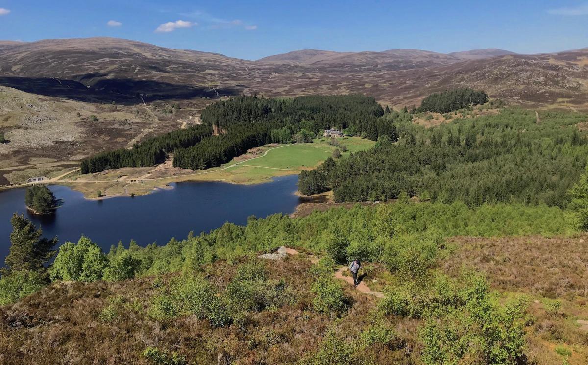
THE 487m high Creag Bheag dominates the Badenoch village of Kingussie. It’s a hill I know well – I’ve enjoyed many a summer evening rock climbing on its little crags and a traverse of the hill makes a lovely afternoon or evening stroll. In this case I climbed the hill as a respite from what felt like weeks of plodding and postholing on snow-covered terrain.
A network of trails and footpaths has been laid out in the Kingussie area and some excellent footpath work has been carried out in collaboration with the Cairngorms National Park. The route to Kingussie’s hill, Creag Bheag, is a good example of this ongoing work.
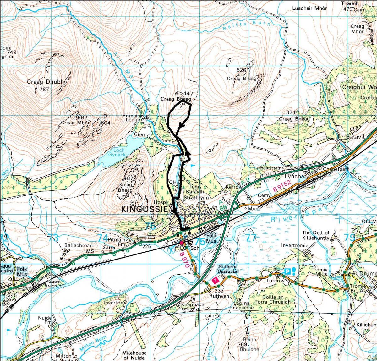
I left the Ardvonie Car Park in Kingussie where there is a board showing the various local walks. I prefer to climb this hill in an anti-clockwise direction - I would rather climb the steeper sections than descend them – so I set off up the road that leads to Kingussie Golf Club. The roads starts to climb immediately and runs parallel to the crashing waters of the River Gynack whose flow has been harnessed to provide Hydro electricity.
Just before the Golf Club car park, a footbridge crosses the river and leads to another tarmac road, which runs to Loch Gynack through the golf course. After a kilometre or so a sign points to a narrow track on the left. This more or less immediately turns right, following the course of a burn for a short distance before climbing wooden steps – 56 of them.
The walk now follows the edge of the golf course to the ruins of an old house before the path continues through a gate, and then through woodland to another gate with lovely views of Loch Gynack with the hills of the Monadh Liath beyond.
It’s usually a bit boggy here but the footpath does well in avoiding most of it before climbing steadily to another set of signposts. I followed the sign for Creag Bheag, the beginning of a 15-minute steep climb to the multi-topped summit of the hill.
With lovely views in all directions this is a great place to linger before setting off down the obvious footpath that runs down to a fence and more woodland. Once through the gate I simply followed the main footpath downhill all the way to a gate which led to a path onto a road. I followed the road downhill for a couple of hundred metres before tuning left down a flight of steps back to a large grassy area adjacent to Ardvonie car park and my waiting car.
Cameron McNeish
ROUTE PLANNER
Map: OS 1:50,000 Landranger sheet 35 (Kingussie & Monadhliath Mountains).
Distance: 3 miles/5km
Time: 2-3 hours
Start/Finish: Ardvonie Car Park in Kingussie (behind the Duke of Gordon Hotel, GR: NH755005)
Public transport: Regular trains to Kingussie from Glasgow, Edinburgh and Inverness. Buses from Inverness (www.travelinescotland.com )
Information: Aviemore TIC, 01479 810930
Route: Follow Ardvonie Road uphill, past St Vincent’s Hospital to a footbridge over the River Gynack. Cross the bridge, turn L and follow a path to a tarmac road. Continue with golf course on either side to a signpost pointing L. Go down a narrow path and almost immediately turn R. Climb wooden steps and turn R at the top. Pass ruined building, go through a gate, follow path through woods to another gate. Go through and climb the hill to L to another set of signs. Climb steeply to summit of Creag Bheag. Descend by the obvious path to a gate in a fence. Go through gate and follow path, ignoring other paths going off L and R, to gate and short path leading to a road. Go down the road for a short distance and turn L down steps to a grassy area adjacent to the car park.


Why are you making commenting on The Herald only available to subscribers?
It should have been a safe space for informed debate, somewhere for readers to discuss issues around the biggest stories of the day, but all too often the below the line comments on most websites have become bogged down by off-topic discussions and abuse.
heraldscotland.com is tackling this problem by allowing only subscribers to comment.
We are doing this to improve the experience for our loyal readers and we believe it will reduce the ability of trolls and troublemakers, who occasionally find their way onto our site, to abuse our journalists and readers. We also hope it will help the comments section fulfil its promise as a part of Scotland's conversation with itself.
We are lucky at The Herald. We are read by an informed, educated readership who can add their knowledge and insights to our stories.
That is invaluable.
We are making the subscriber-only change to support our valued readers, who tell us they don't want the site cluttered up with irrelevant comments, untruths and abuse.
In the past, the journalist’s job was to collect and distribute information to the audience. Technology means that readers can shape a discussion. We look forward to hearing from you on heraldscotland.com
Comments & Moderation
Readers’ comments: You are personally liable for the content of any comments you upload to this website, so please act responsibly. We do not pre-moderate or monitor readers’ comments appearing on our websites, but we do post-moderate in response to complaints we receive or otherwise when a potential problem comes to our attention. You can make a complaint by using the ‘report this post’ link . We may then apply our discretion under the user terms to amend or delete comments.
Post moderation is undertaken full-time 9am-6pm on weekdays, and on a part-time basis outwith those hours.
Read the rules here