
Location: Morrone, Aberdeenshire
Grade: Moderate hill walk
Distance: 6 miles/10km
Time: 4-6 hours
Hill of the Winter Hag
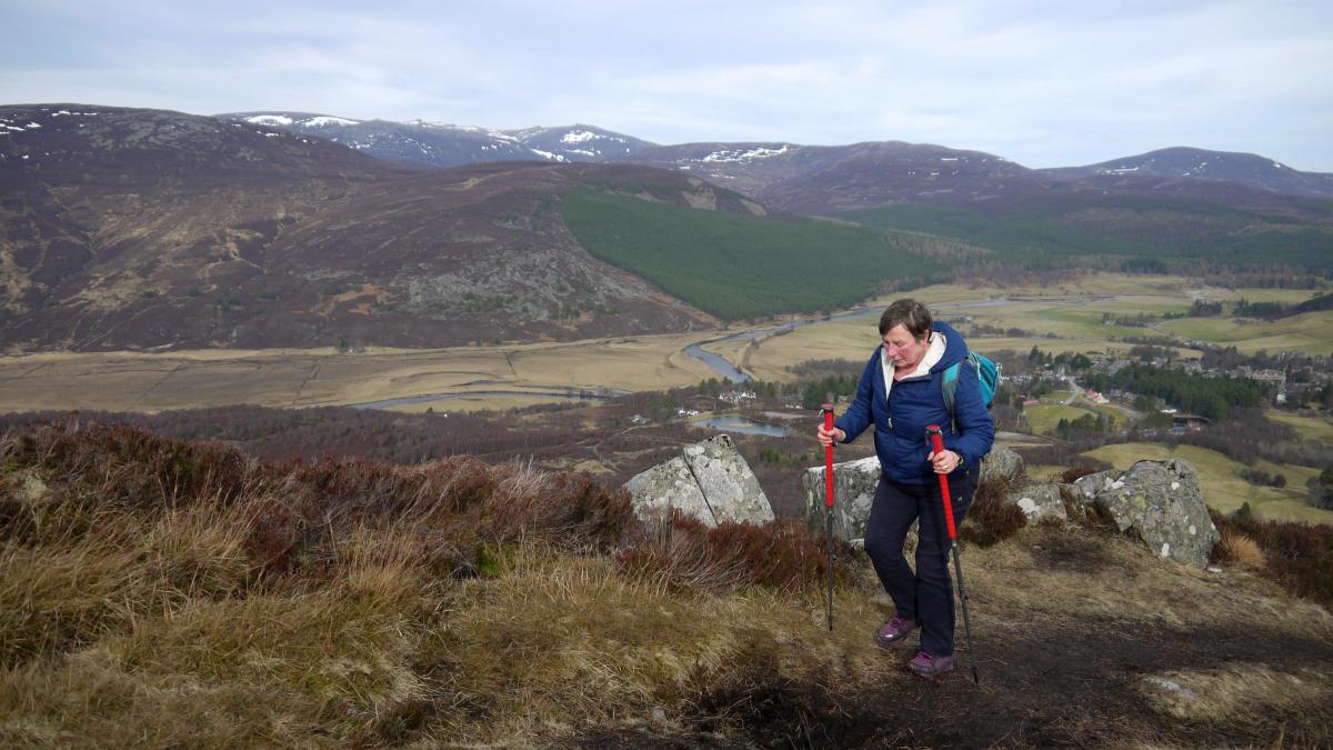
MORRONE is the big, sprawling, heather-covered hill which dominates the Deeside village of Braemar. Standing independent of other hills in the immediate area, Morrone offers views of the historic village and surrounding mountains, particularly the Cairngorms to the north, which are second to none. It's ascent is a good half-day walk for all the family, eased by the fact that the start of the walk is over 300m above sea level!
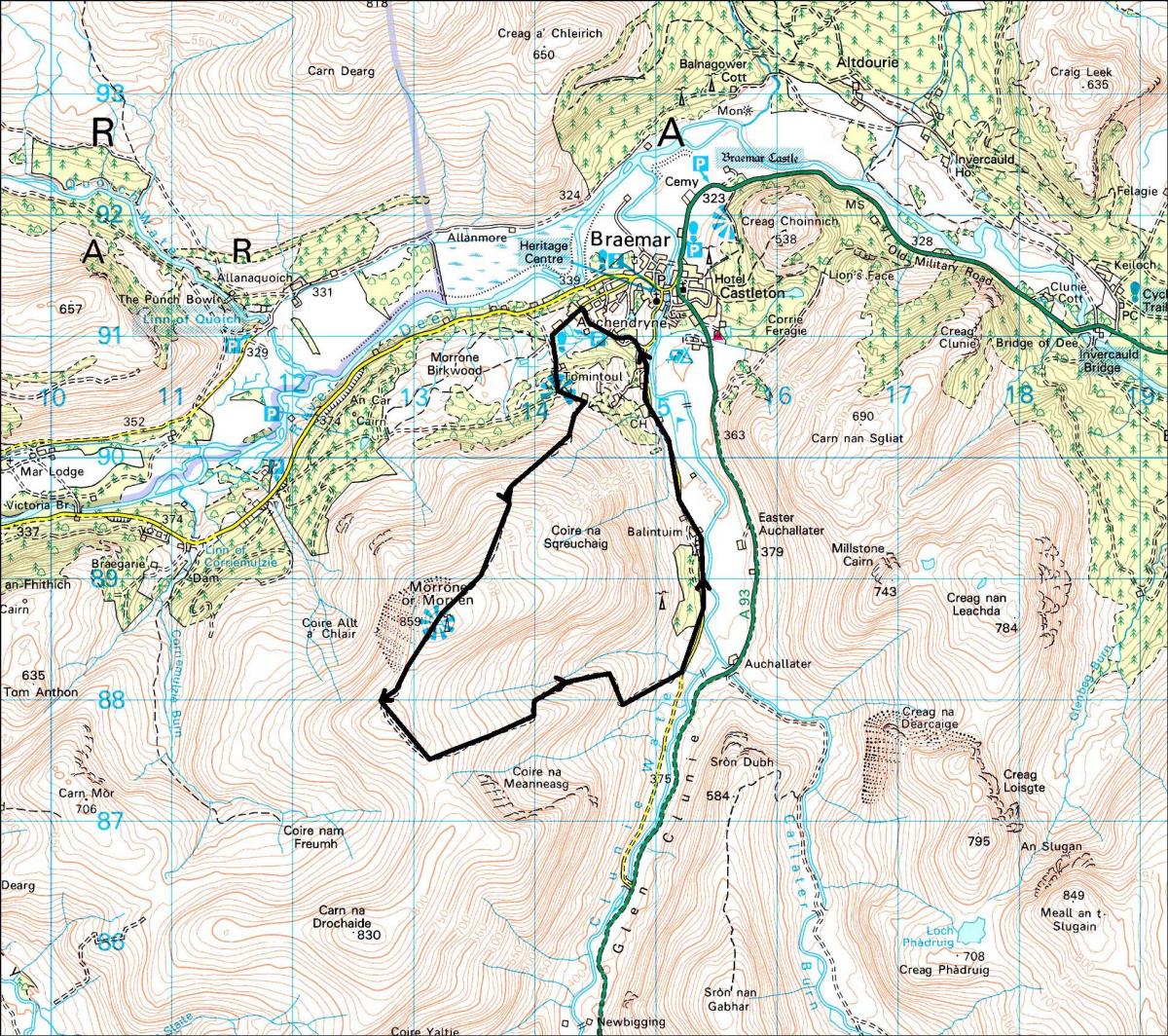
The walk is about 10km in total, and some of that distance is on a quiet surfaced road. From the summit a Landrover track runs down to Glen Clunie to where another minor road takes you back to Braemar. But bear in mind that although Morrone doesn’t look terribly big when compared to some of its more illustrious neighbours, its summit does stand at over 2800ft, and that’s high enough to catch the high winds and storms that often roar down Glen Clunie.
Although popular with mountaineers and hill walkers, Braemar is more than a mere prelude to the hills around it. It’s an ancient settlement. Malcolm Canmore, husband of the saintly Queen Margaret, built the first castle here in 1059 and it was Canmore who is said to have killed Macbeth at Lumphanan in 1057. It was at Braemar that the first Jacobite Rising began in 1715 and Robert Louis Stevenson wrote Treasure Island while living here at the end of the 19th century. Today the village is well known for its royal associations and in particular, the Braemar Gathering which is held on the first weekend in September and is always attended by members of the Royal Family.
Morrone is a Corbett (a Scottish mountain between 2500ft and 2999ft) and has a weather research station and radio relay mast on its summit. Legend states that at one time an old woman used to spend her summers at a shieling close to the summit. The reputation of this Cailleach Bheur, the Winter Hag, was such that it was said she used to call to the red deer hinds, which she would then milk as though they were cows. The name Morrone probably comes from the Gaelic, mor-shron, which means big nose or promontory. The Ordnance Survey call it Morrone or Morven on their maps but there appears to be little reason to refer to it as Morven.
The car park at the top of Chapel Brae in Braemar is our starting point. Close by lies a small lochan, known locally as the duck pond, a place usually ringing with the cackles of mallards. A track passes the pond and leads to the Morrone Birchwoods, a designated National Nature Reserve which is well worth a visit. The route to Morrone follows a private road which runs south to a direction indicator. Leave the road and take a track which runs to the left, leaving it almost immediately to follow a path which runs south round a knoll. Follow this path all the way to the summit. On a clear day the views are fabulous with the high tops of the Cairngorms arrayed before you in all their splendour. Rather than descend the same way, continue south-west to a Landrover track which drops south-westwards before veering east in a large loop to descend easily down to Glen Clunie opposite Auchallater farm. The minor road can then be followed northwards, past the golf course, back to Braemar.
Cameron McNeish
ROUTE PLANNER
Map: OS 1:50,000 Landranger sheet 43 (Braemar & Blair Atholl); Harveys 1:40,000 British Mountain Map, Cairngorms and Lochnagar.
Distance: 6 miles/10km.
Time: 4-6 hours.
Start/finish: Car park at the top of Chapel Brae in Braemar (GR: NO142909).
Public transport: Regular bus service from Aberdeen to Braemar. Details from www.travelinescotland.com
Information: Braemar TIC, 01339 741600.
Route: From the car park a track passes a duck pond and leads to the Morrone Birchwoods NNR. A private road runs S to a direction indicator. Leave the road and take a track which runs to the L, leaving it almost immediately to follow a path which runs S round a knoll. Follow this path all the way to the summit. Continue SW to a Landrover track which drops SW before veering E in a large loop to descend gradually and easily down to Glen Clunie opposite Auchallater farm. The minor road can then be followed N, past the golf course and back to Braemar.


Why are you making commenting on The Herald only available to subscribers?
It should have been a safe space for informed debate, somewhere for readers to discuss issues around the biggest stories of the day, but all too often the below the line comments on most websites have become bogged down by off-topic discussions and abuse.
heraldscotland.com is tackling this problem by allowing only subscribers to comment.
We are doing this to improve the experience for our loyal readers and we believe it will reduce the ability of trolls and troublemakers, who occasionally find their way onto our site, to abuse our journalists and readers. We also hope it will help the comments section fulfil its promise as a part of Scotland's conversation with itself.
We are lucky at The Herald. We are read by an informed, educated readership who can add their knowledge and insights to our stories.
That is invaluable.
We are making the subscriber-only change to support our valued readers, who tell us they don't want the site cluttered up with irrelevant comments, untruths and abuse.
In the past, the journalist’s job was to collect and distribute information to the audience. Technology means that readers can shape a discussion. We look forward to hearing from you on heraldscotland.com
Comments & Moderation
Readers’ comments: You are personally liable for the content of any comments you upload to this website, so please act responsibly. We do not pre-moderate or monitor readers’ comments appearing on our websites, but we do post-moderate in response to complaints we receive or otherwise when a potential problem comes to our attention. You can make a complaint by using the ‘report this post’ link . We may then apply our discretion under the user terms to amend or delete comments.
Post moderation is undertaken full-time 9am-6pm on weekdays, and on a part-time basis outwith those hours.
Read the rules here