
Location: Creag a’ Chlamhain Deeside
Grade: Easy hill walk
Distance: 2.5 miles/4km
Time: 2 hours
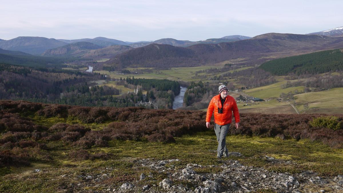
WE had stopped at the car park at Balmoral Castle just opposite Crathie Church and a glimpse at the map showed what looked like an interesting little hill in the cleft of the A93 and the B976, the old military road to Gairnshiel. The hill is called Creag a’ Chlamhain, and there is a high communications mast at the 465m summit, but that doesn’t detract from the wonderful views this little hill offers.
We left the car park and walked along the A93 for a couple of hundred metres, uncomfortably aware of how fast people drive along this section of road. Just as we turned onto the old Military Road a track eased off to the right, winding its way steadily uphill towards the wooded slopes of Creag a’ Chlamhain.
It’s a steady pull up and the track passes between some buildings that looked like holiday houses and sheds that look as though they’ve been set up to dry wooden logs. This is Ardoch and the main house is the former home of Rob Bain, a well- known local character whose mother Jean Bain was the last native speaker of Deeside Gaelic. She died in 1984.
Rob and his parents worked here as crofters, but in fact the land wasn’t technically a croft. Aberdeenshire was not within the geographical scope of the Crofters’ Holdings (Scotland) Act 1886 and as a result the tenants had very few legal rights. As Andy Wightman explains in his excellent book, The Poor Had No Lawyers, the tenants of the land were never more than a year away from eviction.
Rob Bain died in July 2010 and the house and the adjoining land were sold by Invercauld Estate in 2011. If things had been different Ardoch would probably still be crofted and this part of Aberdeenshire may well have been a thriving part of the Gaeltachd.
Beyond the buildings the landscape changed and became more open and I was surprised to find us walking through the remains of an old village. Who lived here; what moved the people to abandon their homes? It’s a wonderful position for a small township with views up Glen Gairn and across to the Corbett of Culardoch.
The track begins to climb more steeply here, up through a wood of pine, birch and juniper to the bare heather slopes of the double-topped summit. The first top has the communications mast dominating it but wander beyond that, your gaze taken by a fine view of Lochnagar in front of you, to the second summit with its big cairn and look west along the narrowing strath of the Dee, past the turrets of royal Balmoral Castle to the big hills around Braemar, Carn na Drochaide and Morrone.
The combination of pinewood and river, green fields and big rounded hills makes upper Deeside so spectacular and from this high point you can witness it all. I decided this was one of the best viewpoints in the southern Cairngorms, and one that I’ll certainly return to time and time again.
Cameron McNeish
ROUTE PLANNER
Map: OS 1:25,000 Explorer Sheet 388 (Lochnagar, Glen Muick & Glen Clova).
Distance: 2.5 miles/4km.
Time: 2 hours.
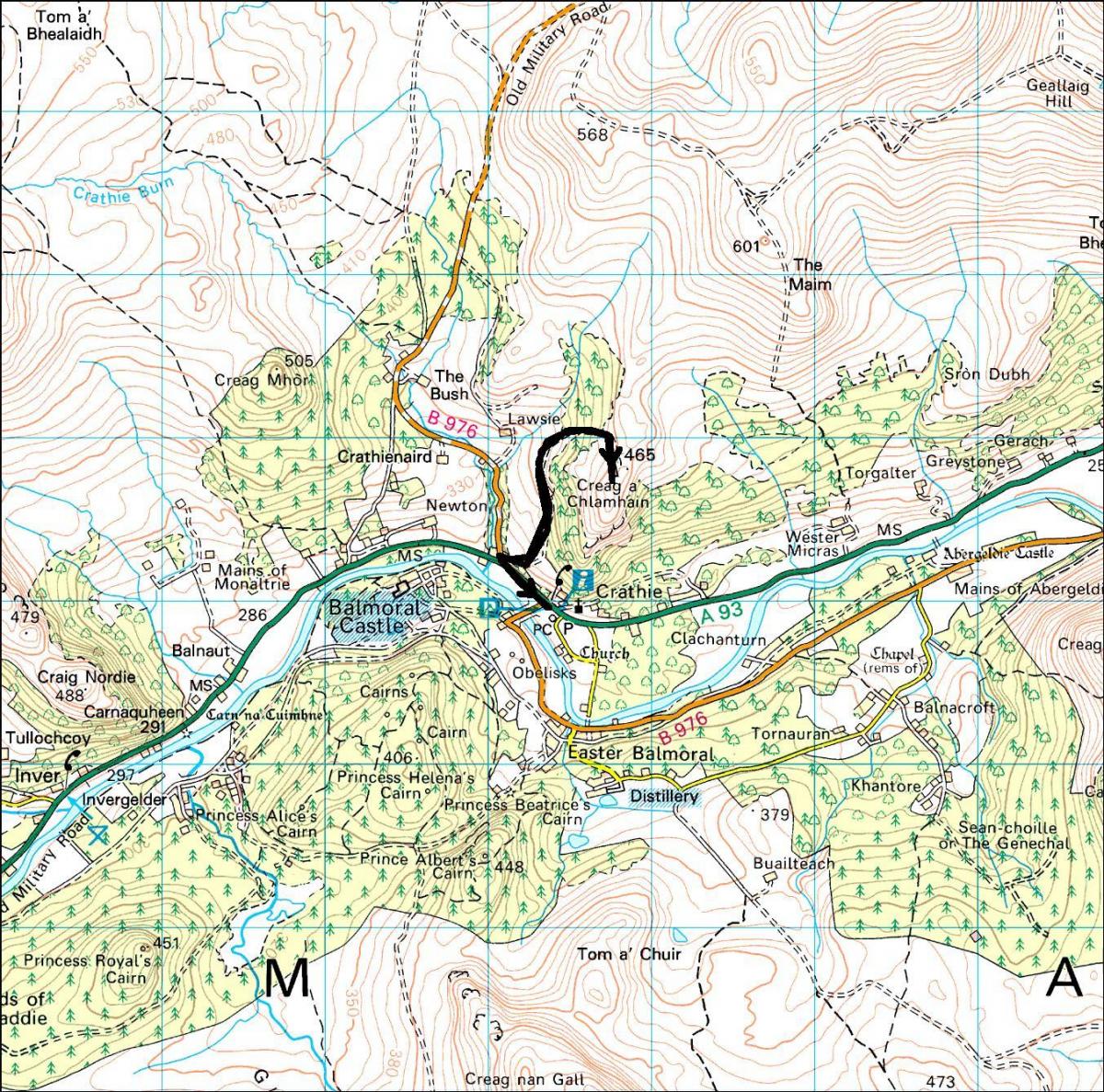
Start/Finish: Balmoral car park off A93 at Crathie (GR: NO 265950).
Public transport: Stagecoach bus 201 runs between Aberdeen and Braemar, stopping at Crathie. Details from www.travelinescotland.com or www.stagecoachbus.com
Information: Ballater TIC, 01339 755306.
Route: Leave the car park and with great care head W along the busy A93. After about 200 metres turn R onto the B976 and after a very short distance turn R again onto a track. Follow it as it begins to climb, bearing to the L as it passes between some buildings. Beyond the buildings the gradient eases off then steepens again as you pass some ruins and enter more woodland. Go through the woods to reach the bare summit slopes. Pass the first summit with the big communications mast and continue over heather covered ground to the large summit cairn. Return the same way.


Why are you making commenting on The Herald only available to subscribers?
It should have been a safe space for informed debate, somewhere for readers to discuss issues around the biggest stories of the day, but all too often the below the line comments on most websites have become bogged down by off-topic discussions and abuse.
heraldscotland.com is tackling this problem by allowing only subscribers to comment.
We are doing this to improve the experience for our loyal readers and we believe it will reduce the ability of trolls and troublemakers, who occasionally find their way onto our site, to abuse our journalists and readers. We also hope it will help the comments section fulfil its promise as a part of Scotland's conversation with itself.
We are lucky at The Herald. We are read by an informed, educated readership who can add their knowledge and insights to our stories.
That is invaluable.
We are making the subscriber-only change to support our valued readers, who tell us they don't want the site cluttered up with irrelevant comments, untruths and abuse.
In the past, the journalist’s job was to collect and distribute information to the audience. Technology means that readers can shape a discussion. We look forward to hearing from you on heraldscotland.com
Comments & Moderation
Readers’ comments: You are personally liable for the content of any comments you upload to this website, so please act responsibly. We do not pre-moderate or monitor readers’ comments appearing on our websites, but we do post-moderate in response to complaints we receive or otherwise when a potential problem comes to our attention. You can make a complaint by using the ‘report this post’ link . We may then apply our discretion under the user terms to amend or delete comments.
Post moderation is undertaken full-time 9am-6pm on weekdays, and on a part-time basis outwith those hours.
Read the rules here