

Location: Around Carbisdale Castle, Easter Ross
Grade: Easy
Distance: 4 miles/7km
Time: 2-3 hours
I remember it as a Youth Hostel, by far the grandest of all the buildings in the Scottish Youth Hostel Association’s portfolio.
Originally built for the Duchess of Sutherland, it was later gifted to SYHA in 1945 by the Salveson family. Eventually, the hostels charity just couldn’t afford the massive costs of the building’s maintenance and upkeep any longer and five years ago it was sold. At the moment a large refurbishment is being carried out to turn it into a ‘private luxury home’.
However grand and impressive it may be, it was merely a backdrop for my wife and myself. I was more enthusiastic about visiting the site of the Battle of Carbisdale, part of the Wars of the Three Kingdoms, which took place close to the village of Culrain in 1650.
The Royalist leader, James Graham, the Marquess of Montrose was defeated and injured but managed to escape the Covenanter forces. However, this turned out to be his last battle; he was later captured in Assynt and taken to Edinburgh Castle where he was beheaded.
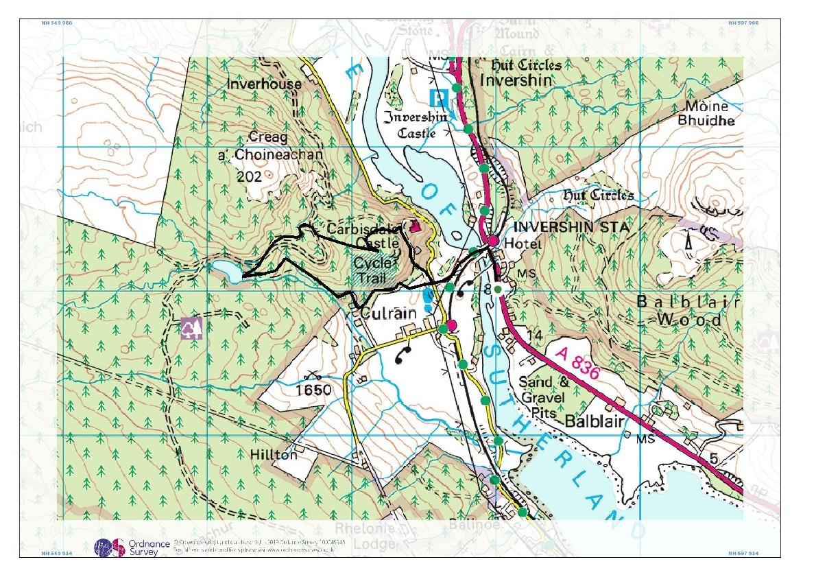
We parked in a wide layby on the west side of the A836, just beyond the railway viaduct. A pedestrian bridge below the viaduct carried us across the waters of the Kyle of Sutherland before a narrow footpath took us to a road that wriggles round the foot of the Carbisdale hill, correctly called Creag a’ Choineachan.
We followed the road for a very short distance before entering the grounds of the castle itself where another road led us gently uphill to the firmly padlocked gates of Carbisdale Castle. It was obvious that contractors were busy inside so we turned our back on the Scots Baronial building and instead followed a wet path uphill through the trees.
Very soon the trees thinned out – only some very young birches, pine and rowan were left and at a large rock, a lovely viewing platform, we dropped downhill through some rather dense and very wet broom, down towards the Carbisdale Burn. This chuckling burn, with small waterfalls higher up, doesn’t actually have a name on the OS map but Carbisdale Burn seems as good as any.
Beyond the waterfalls we discovered the stream actually issued from a beautiful little lochan. Hidden by pines and birch this lochan has an island covered in pink rhododendrons. It’s a fabulous spot, particularly as the sun was now shining and I remarked to my wife that I’d love to return with a tent and spend the night here.
From the loch we began our long descent on an excellent path that twisted down through the woods towards the site of the Battle of Carbisdale. There’s not a lot to see other than an information panel but essentially Montrose set up camp on the lower slopes of Creag a’ Choineachan, above the Kyle of Sutherland.
History records that Montrose’s army of mercenaries raised earthworks to form a defensive position, but were lured out of their encampment by a small force of cavalry under the command of Lt Col Archibald Strachan. Thinking the small force was all they had to contend with, Montrose led his men out into the open where they were ambushed on either side by hidden soldiers. Montrose was injured in the melee but managed to escape. He was betrayed to the Covenanters and captured several days later.
It was hard to imagine such a dreadful scene of battle as we waltzed down the twisting footpath, crossed the burn again and made our way back down towards the castle grounds. All that remained was to head back over the footbridge, enjoy the views of the Kyle of Sutherland in both directions, and return to our campervan for a brew and a bun.
Cameron McNeish
ROUTE PLANNER
Map: OS 1:50,000 Landranger sheet 21 (Dornoch & Alness); OS 1:25,000 Explorer sheet 441 (Lairg, Bonar Bridge & Golspie).
Distance: 4 miles/7km
Time: 2-3 hours
Start/Finish: Layby on A836 at NH575951
Public transport: Trains from Inverness to Wick/Thurso stop at Culrain station which is 1km from the start of the walk. Details from www.scotrail.co.uk
Information: Inverness TIC (01463 252401). www.walkhighlands.co.uk
Route: Cross the Kyle of Sutherland by a pedestrian bridge below the railway viaduct. Follow a footpath to reach a road. Turn R and follow road for short distance then turn L between stone gateposts. Follow road uphill until you reach the gates of Carbisdale Castle. Turn immediately L up a path through the trees. Follow it to a large rock on top of the hill and take another descending path through dense bushes on the R, all the way to a wooded viewpoint. Go R opposite the viewpoint and descend until you meet a forestry track. Go L on the track, R at the next junction and follow main path uphill, ignoring a track on the L that runs down to a bridge. Continue climbing until you reach a bench by waterfalls. Continue uphill to another junction. Turn L and follow path to the lochan. Turn L at the lochan, cross a bridge and follow twisting path downhill to information board about the Battle of Carbisdale. From here go L and descend to a bridge (the one you saw earlier). Cross it, keep R and continue keeping R until you reach a gate at a house. Turn L here and then L again. Follow this path down to the walled gardens. At the next junction turn R again down to an old car park. The road back to the viaduct bridge is now immediately in front of you.


Why are you making commenting on The Herald only available to subscribers?
It should have been a safe space for informed debate, somewhere for readers to discuss issues around the biggest stories of the day, but all too often the below the line comments on most websites have become bogged down by off-topic discussions and abuse.
heraldscotland.com is tackling this problem by allowing only subscribers to comment.
We are doing this to improve the experience for our loyal readers and we believe it will reduce the ability of trolls and troublemakers, who occasionally find their way onto our site, to abuse our journalists and readers. We also hope it will help the comments section fulfil its promise as a part of Scotland's conversation with itself.
We are lucky at The Herald. We are read by an informed, educated readership who can add their knowledge and insights to our stories.
That is invaluable.
We are making the subscriber-only change to support our valued readers, who tell us they don't want the site cluttered up with irrelevant comments, untruths and abuse.
In the past, the journalist’s job was to collect and distribute information to the audience. Technology means that readers can shape a discussion. We look forward to hearing from you on heraldscotland.com
Comments & Moderation
Readers’ comments: You are personally liable for the content of any comments you upload to this website, so please act responsibly. We do not pre-moderate or monitor readers’ comments appearing on our websites, but we do post-moderate in response to complaints we receive or otherwise when a potential problem comes to our attention. You can make a complaint by using the ‘report this post’ link . We may then apply our discretion under the user terms to amend or delete comments.
Post moderation is undertaken full-time 9am-6pm on weekdays, and on a part-time basis outwith those hours.
Read the rules here