
Location: Rockcliffe, Dumfries & Galloway
Grade: Easy coast paths and forest tracks
Distance: 4 miles/6.5km
Time: 2 hours
A hidden delight
I GUESS the rugged hills of Galloway will always be my prime reason for visiting Scotland’s south-west, but it would be wrong to dismiss the other delights of the area. History, romance, seascapes, wildlife and great coastal walks are all intertwined in a region of Scotland that many curiously disregard or are simply unaware of.
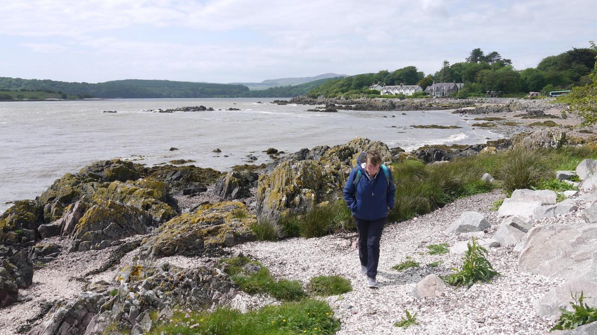
On a recent trip to the area we stopped overnight in the delightful village of Rockcliffe. A quiet offshoot of the A710 carried us down to the rocky foreshore of the village and a couple of miles north another quiet road runs from the A710 to the village of Kippford. A series of footpaths link the two villages and you can choose between a straightforward coastal walk or a higher route through the forest with some wonderful views of the lovely estuary of the Urr Water and beyond to the open waters of the Irish Sea.
Much of the area is owned by the National Trust for Scotland and is fringed with wildflowers and shaded woodland. Away from the coast the shells and shingle give way to patches of ancient broadleaved woodland and meadows, rich with flowers, butterflies and birds. We chose to take the high route through the forest and enjoy the views, before descending to Kippford for a welcome pint of beer in the hotel. We then returned to Rockcliffe along the delightfully bird-loud coastal path, totally and utterly captivated by the place.
We had parked for the night on the campsite so we made our way down to the village and were a little unsure of the best route to Kippford. A local gentleman, tending his garden, helped us out: ‘Go up that little hill and turn left. That’s the Jubilee Path and it will take you right into Kippford or you can cut off and climb through the forest to an excellent viewpoint.’
Sure enough, there at the top of the rise was a well made, wide footpath, and signposted too. We followed it for a short distance to a path junction. A signpost indicated Mark Hill so we followed that, climbing steadily through the forest.
I kept an eye on the map, well aware that forestry tracks are not always well documented by the OS. At an obvious junction we turned left, still climbing and then left again, my instincts suggesting that if we were going to find a viewpoint it would be close to the highest point on the hill.
At this point we came across a narrow footpath breaking off to the left and relying purely on a gut reaction we followed it, climbing more steeply now until we broke free of the trees by some large rocks. This was the viewpoint we were promised and a great view it was, looking out over the estuary of the Rough Firth.
A causeway from the island looked as though it was appearing with the falling of the tide and we half promised ourselves a visit to the island if, in fact, we could follow the causeway. We were later told by the barman in the hotel in Kippford that it wasn’t a complete causeway, so that put paid to our tentative plans.
From the viewpoint the footpath descended steeply and eventually joined up with the main path to Kippford, a lovely trail through mixed woodland. Houses began to emerge from the trees and soon we had reached a tarmac road, which turned left and dropped us down to the seafront.
A short stroll along the seafront took us to the Anchor Hotel and a welcome pint of beer, before heading back to Rockcliffe via the straightforward coastal path.
Cameron McNeish
ROUTE PLANNER
Map: OS 1:25,000 Explorer sheet 313 (Dumfries & Dalbeattie)
Distance: 4 miles/6.5km
Time: 2 hours
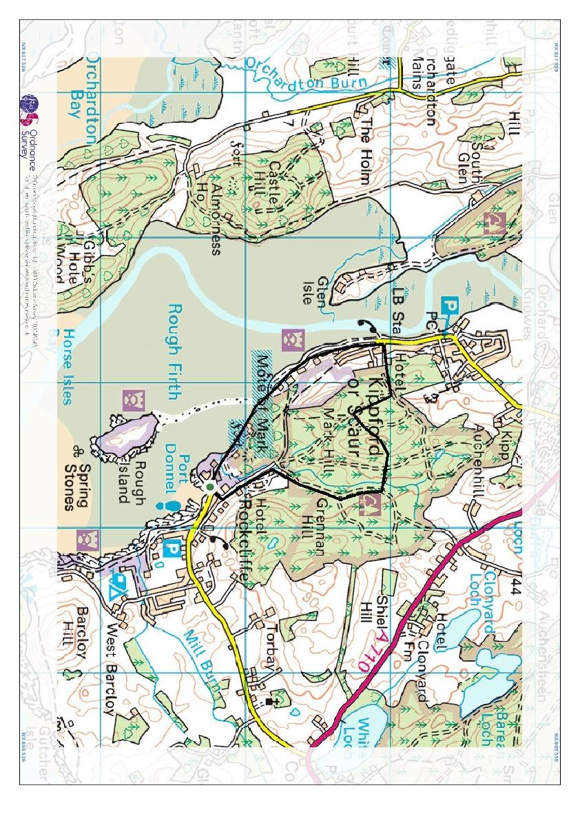
Start/Finish: Car park at the road-end in Rockcliffe (GR: NX 850536).
Public transport: Houstons bus service 372 from Dumfries calls at Rockcliffe. Details from www.houstonscoaches.co.uk or 01576 203874
Information: Newton Stewart TIC (01671 402431), https://dumgal.gov.uk/tourism
Route: From the car park at the end of the sea-front in Rockcliffe climb the short hill on the landward side and turn left at the top. Follow this road then track into the woods to an obvious junction with a signpost marked to Kippford. Turn right at the junction and climb this track through the forest, disregarding any other routes to the left or right. Continue to an obvious T-junction and turn left still climbing slightly. Turn left again at the next obvious junction and near the top of the hill take the path that strikes off to the left. Follow this track to the viewpoint. Descend S and turn left where the path meets the main Kippford track. Follow this track into Kippford then follow the obvious coastal path back to Rockcliffe.


Why are you making commenting on The Herald only available to subscribers?
It should have been a safe space for informed debate, somewhere for readers to discuss issues around the biggest stories of the day, but all too often the below the line comments on most websites have become bogged down by off-topic discussions and abuse.
heraldscotland.com is tackling this problem by allowing only subscribers to comment.
We are doing this to improve the experience for our loyal readers and we believe it will reduce the ability of trolls and troublemakers, who occasionally find their way onto our site, to abuse our journalists and readers. We also hope it will help the comments section fulfil its promise as a part of Scotland's conversation with itself.
We are lucky at The Herald. We are read by an informed, educated readership who can add their knowledge and insights to our stories.
That is invaluable.
We are making the subscriber-only change to support our valued readers, who tell us they don't want the site cluttered up with irrelevant comments, untruths and abuse.
In the past, the journalist’s job was to collect and distribute information to the audience. Technology means that readers can shape a discussion. We look forward to hearing from you on heraldscotland.com
Comments & Moderation
Readers’ comments: You are personally liable for the content of any comments you upload to this website, so please act responsibly. We do not pre-moderate or monitor readers’ comments appearing on our websites, but we do post-moderate in response to complaints we receive or otherwise when a potential problem comes to our attention. You can make a complaint by using the ‘report this post’ link . We may then apply our discretion under the user terms to amend or delete comments.
Post moderation is undertaken full-time 9am-6pm on weekdays, and on a part-time basis outwith those hours.
Read the rules here