Extreme weather, from above.
The engineers and scientists at Dundee University's Satellite Receiving Station record conditions above the earth year round, but their work has been in particular demand in the last month, as Scotland experienced exceptional weather conditions including high winds, blizzards and flooding.
The images below, transmitted from satellites as they pass over the station, give an aerial view of Britain on three of the most significant days, including Tuesday's devastating storm.
Helen Chivers, a Met Office Forecaster, explains what they show:

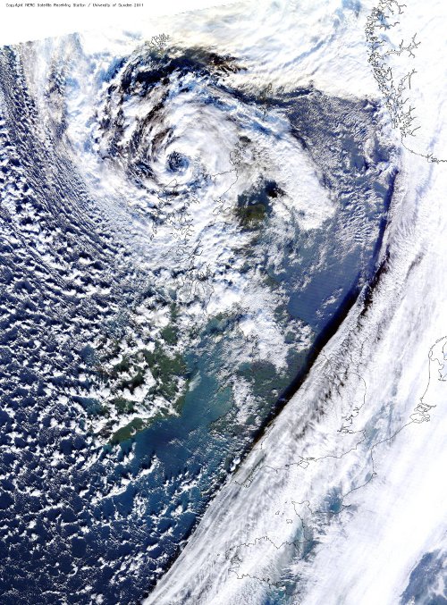
January 3rd: This image shows the most recent Atlantic storm to affect the UK. The 'eye of the storm' can be seen as a swirl of cloud to the east of Aberdeenshire. An interesting feature is that you can see the shadow cast by the clouds over the North Sea. This brought storm force winds to Scotland, especially through the Central Belt where gusts of 102mph were recorded at Blackford Hill, Edinburgh, 97mph at Islay and 91mph at Glasgow, Bishopton Airport.
December 28th: The image above shows the intense Atlantic depression (low pressure area) which brought stormy conditions to the country. The 'eye of the storm' shows up clearly as the swirl of cloud to the north of the Hebrides. This brought severe gale force westerly winds and frequent squally showers. Gusts of 79 mph were recorded on Tiree and South Uist.

December 18th: This image shows much of Scotland covered in snow following a few days which saw snow showers falling across the country. By the 18th the showers were mainly affecting coastal areas with clear skies over land allowing us to see the snow covered land. A temperature of -9.4 degrees C was recorded at Loch Glascarnoch early on December 18th - the lowest temperature recorded in the UK during December.
Online extra: Neil Lonie, manager of Dundee University's satellite receiving station, explains how the images are gathered


Why are you making commenting on The Herald only available to subscribers?
It should have been a safe space for informed debate, somewhere for readers to discuss issues around the biggest stories of the day, but all too often the below the line comments on most websites have become bogged down by off-topic discussions and abuse.
heraldscotland.com is tackling this problem by allowing only subscribers to comment.
We are doing this to improve the experience for our loyal readers and we believe it will reduce the ability of trolls and troublemakers, who occasionally find their way onto our site, to abuse our journalists and readers. We also hope it will help the comments section fulfil its promise as a part of Scotland's conversation with itself.
We are lucky at The Herald. We are read by an informed, educated readership who can add their knowledge and insights to our stories.
That is invaluable.
We are making the subscriber-only change to support our valued readers, who tell us they don't want the site cluttered up with irrelevant comments, untruths and abuse.
In the past, the journalist’s job was to collect and distribute information to the audience. Technology means that readers can shape a discussion. We look forward to hearing from you on heraldscotland.com
Comments & Moderation
Readers’ comments: You are personally liable for the content of any comments you upload to this website, so please act responsibly. We do not pre-moderate or monitor readers’ comments appearing on our websites, but we do post-moderate in response to complaints we receive or otherwise when a potential problem comes to our attention. You can make a complaint by using the ‘report this post’ link . We may then apply our discretion under the user terms to amend or delete comments.
Post moderation is undertaken full-time 9am-6pm on weekdays, and on a part-time basis outwith those hours.
Read the rules hereComments are closed on this article