
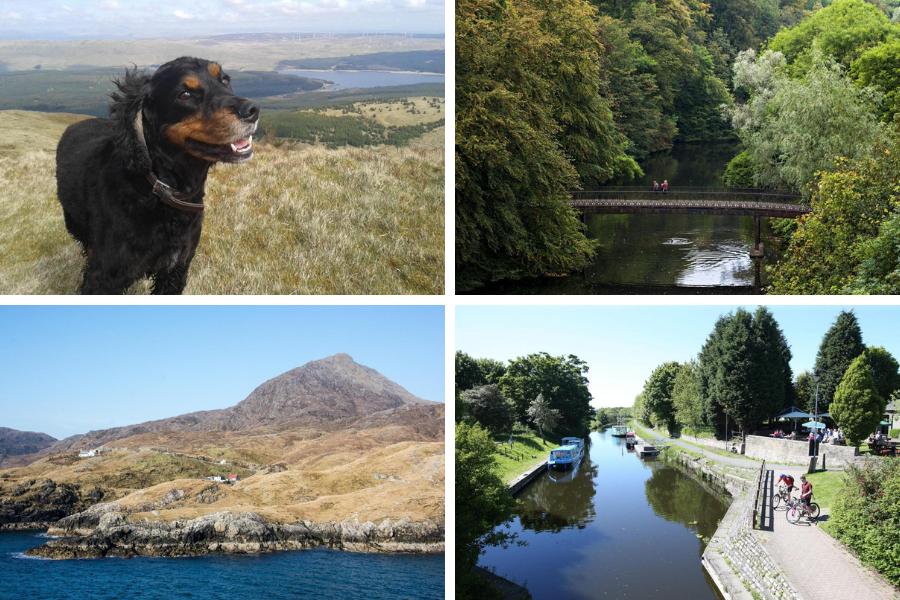
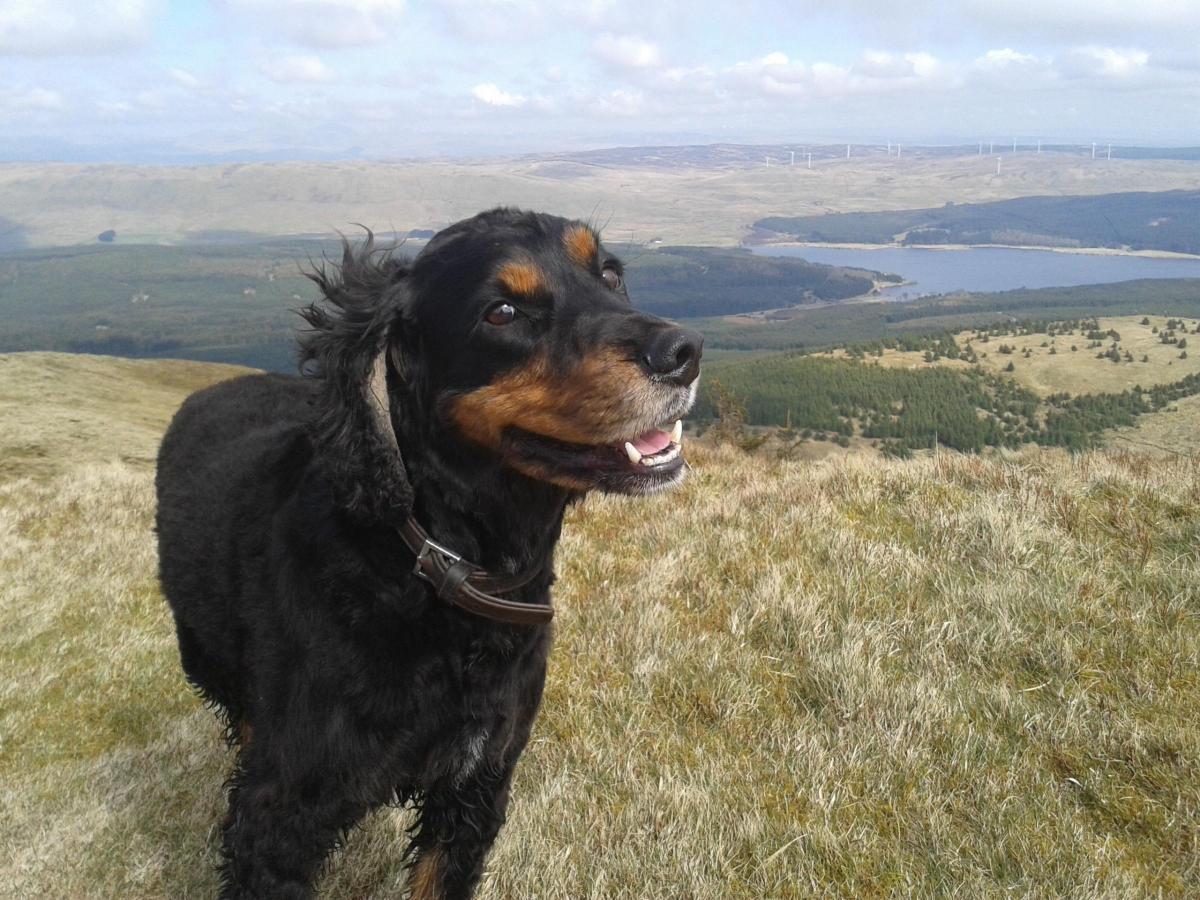

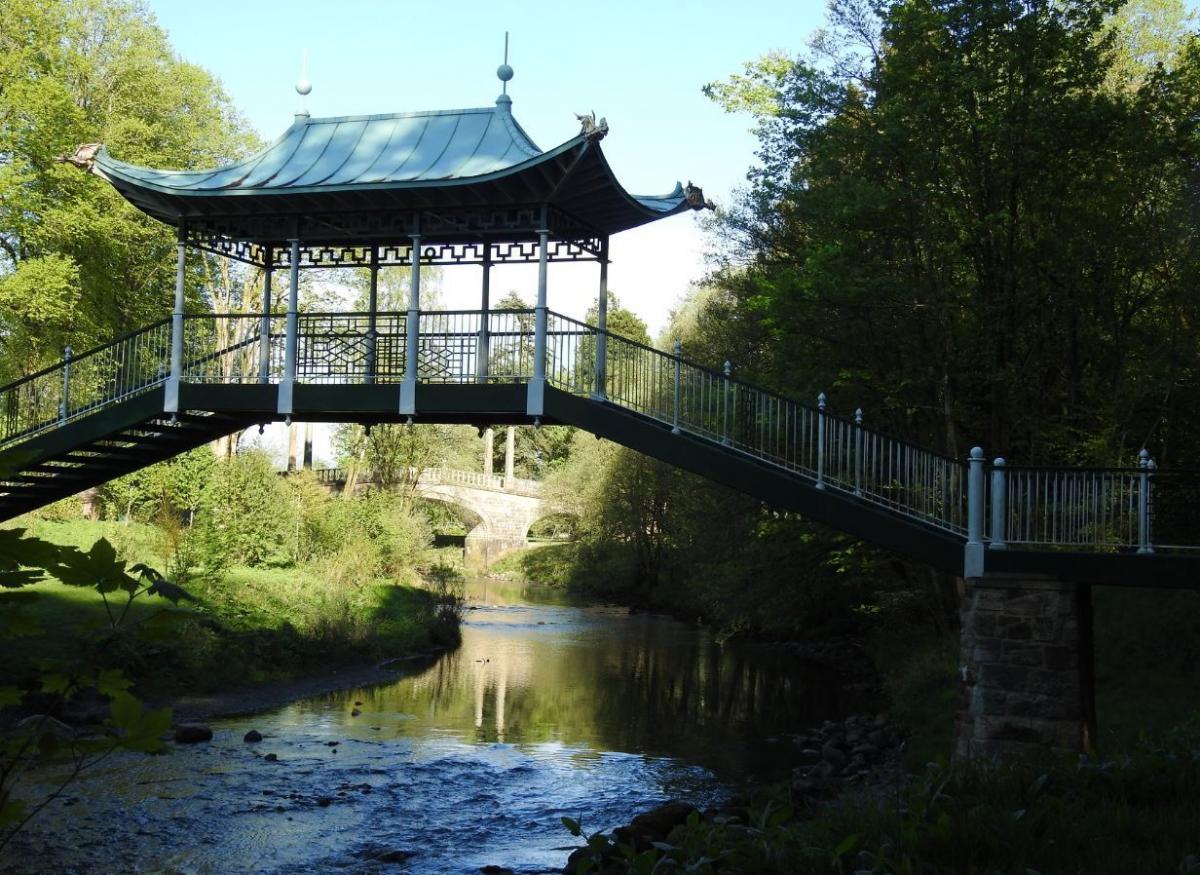
Dumfries House and the River Lugar, Ayrshire
Time: Two to three hours
What makes it special: A chance to see Prince Charles' handiwork
You probably know the story of how Dumfries House near Cumnock in Ayrshire was saved by Prince Charles, but you should really see the results for yourself. The house, designed by John and Robert Adam, is full of furniture designed by Thomas Chippendale, but the grounds are just as glorious.
There are plenty of places to start your walk but one of the best is the small car park off the Barony Road near the A76 at Auchinleck. This is the northernmost point of the Duchess of Rothesay Avenue, a long, straight path lined with lime trees and a quarter of a million daffodils. Go mid-morning and, if you’re lucky, you will walk all the way in the sun. You can also stop half way at the Temple Gate, a 300-year-old gatehouse restored as part of the ongoing work on the estate.
At the bottom of the avenue, wander round the arboretum and check out the Japanese-style bridge over the River Lugar. The bridge is only a few years old but its design was taken from an original drawing submitted by the Scottish architect Robert Weir Schultz in the 19th century.
Next follow the River Lugar through the woods towards Cumnock. The town is the capital of Ayrshire's industrial history and you'll see plenty of evidence of it on the walk, including the hoist of the former Barony mine on the horizon, like a giant letter A. Wander along the river before turning north and heading back up to the car park.
Pit Stop: The Coach House Cafe on the Dumfries House estate is a great place to stop. It’s open seven days a week and serves that most modern of delicacies: the vegan sausage roll.
MARK SMITH
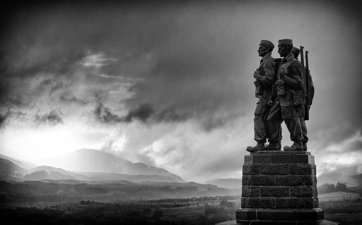
The Commando Memorial and High Bridge, Spean Bridge, Lochaber
Time: Around 45-60 minutes, or longer to fully appreciate the scenery.
What makes it special: It might be just shy of three miles but this little walk has everything: breathtaking views of Ben Nevis, oodles of history, a good mixture of flat paths and short inclines and accessibility
It is easily located, by foot a mile from the village of Spean Bridge, or start half-way up the hill, through a gate off the A82. Go through a kissing gate at the foot of the Commando Memorial, the A-listed monument built in 1952 to soldiers who trained here during the Second World War.
The walk is steeped in childhood memories and family landmarks, weaving through wooded and open paths along the River Spean, close to my old primary school, Kilmonivaig, and the pebbled shore of the River Spean, where my sister and I were taken for picnics with banana sandwiches in the holidays.
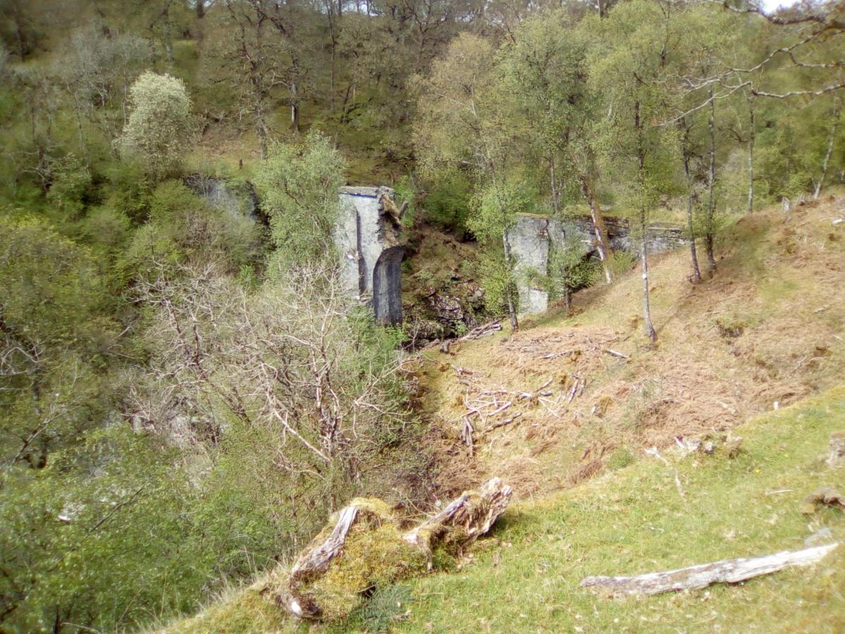
The old croft house where my mother grew up, Achnahannet, is visible in the distance, at the start of the route. The first half of the walk is almost entirely downhill, through woodland, grass and heath and a joy to run.
The path eventually joins the old railway line, and arrives at the ruins of High Bridge, crossing the steep gorge of Glen Spean. (The ruins are very dangerous and must not be accessed.) There is an information board about the bridge and its role in the 1745 Jacobite rising. It was the site where the first shots were fired against British troops by Jacobites loyal to Prince Charles Edward Stuart. Three days after the clansmen's victory, the Prince raised the standard at Glenfinnan, marking the start of the doomed campaign.
Scotland's favourite gentle strolls: Part one
The path eventually veers away from the river and crosses heathland, ascending gradually and then sharply. There is a welcome seat, ahead of the steepest incline to take in lovely views of Aonach Mor and Ben Nevis.
The path is well made and suitable for some all-terrain baby buggies. However, the wooden bridges can be slippery and dogs must be kept on leads.
Pit stop: The route ends by the side of the A82, around half a mile from the village, where walkers can enjoy a restorative cup of tea and decent scones at Spean Bridge Woollen Mill.
CAROLINE WILSON
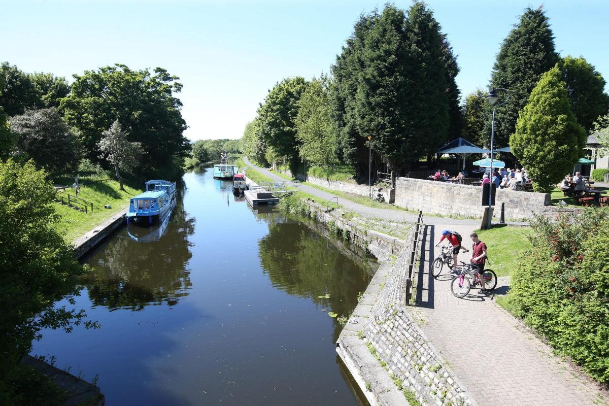
Strathclyde Park, Motherwell
Time: It's up to you really. There are so many options. A full circuit on the path alongside the loch is just over three miles
What makes it special: The park has 1,100 acres of mature woodland, rough wetland and open water, providing a home for more than 150 different species of animals and birds
A level tarmac path runs round the loch. This is the one I tend to do, and if I am feeling energetic I walk around twice. You will, however, spend your time avoiding the cyclists and dog walkers. I do this walk with my friend who is afraid of dogs, which is entertaining to say the least! From Strathclyde Park to Baron's Haugh RSPB nature reserve short sections of the walkway have relatively steep gradients. A detour around the nature reserve will reveal meadow, marshland, scrub and woodland habitats. After leaving the reserve the walkway passes Dalzell Estate, originally a royal hunting forest. In the 18th century the estate lands were transformed into an orderly and landscaped park. From Dalzell Estate and beyond Adders' Gill the path is prone to flooding, especially in winter, so an alternative route is signposted.
Pit stop: The waterfront cafe is good for coffee and cake, or a soup and sandwich.
JACKIE BROGAN
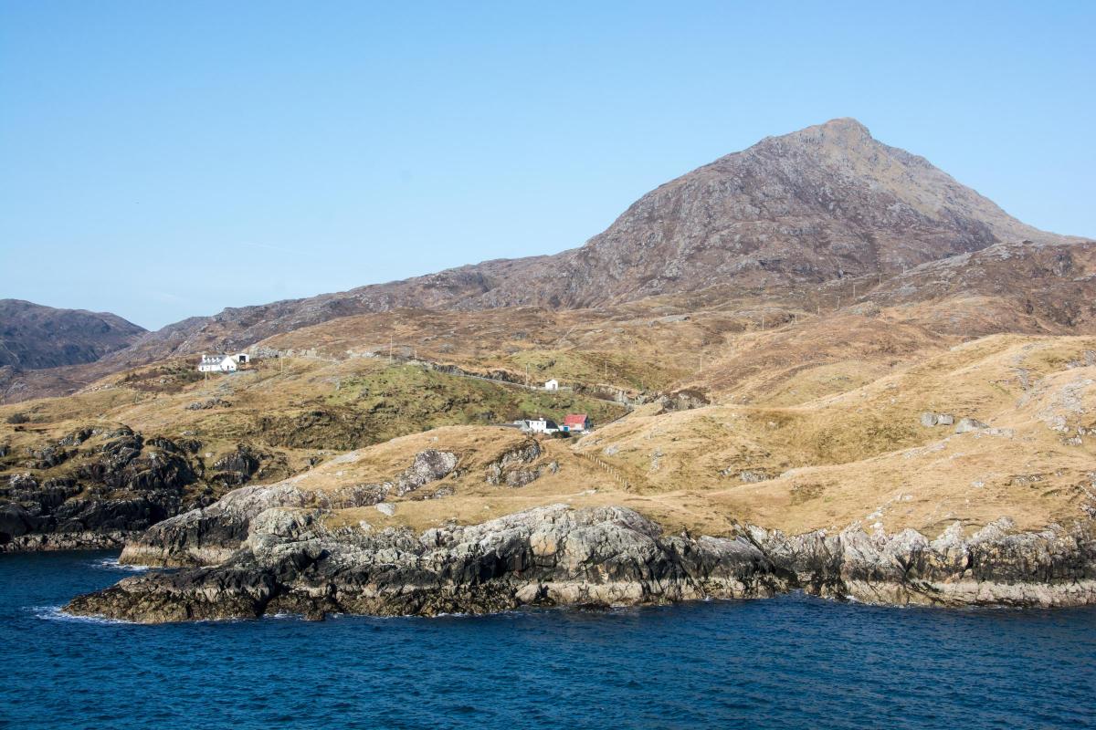
Urgha to Rhenigidale – The Postman’s Path – Harris
Time: 2-4 hours.
What makes it special: An ancient island route that features stunning coastal views, sheltered coves and abandoned villages
Until its road was opened in 1990, the tiny settlement of Rhenigidale could only be reached by boat, or via the Postman’s Path, a spectacular and in places challenging, 3.75-mile route across hill, bog and rock. It wasn’t only the postie that used the path, of course; children walked the route once a week, in all weathers, to and from secondary school in Tarbert.
Starting out in Urgha, two miles from Tarbert, the gentle start offers great views of Clisham, the highest peak on the Western Isles, giving way to a steeper descent. The detour to the deserted settlement of Molinginis – which once had 40 residents and its own school – is well worth the diversion.
Further along the route, the zig-zag descent to the shore at Loch Trolamaraig can be tricky, but it’s the perfect place to enjoy a picnic if the weather allows. If you’re lucky, you might see seals or even an otter near the shoreline.
Heading back upwards, past more abandoned cottages and round steep cliffs, Todun, the 528m hill above Loch Seaforth, dominates the latter stages of the walk. Through a gate, you eventually reach the now famous road, built after a David and Goliath fight by local man Kenny Mackay, the former postman who walked the path three times a week and still lives in the village.
Scotland's favourite gentle strolls: Part one
Standing above Rhenigidale, on a clear day you can see to the Shiant islands and beyond. You can see why Mr Mackay and the other residents love the place so much.
Pit stop: Facilities are limited – there is no hotel, shop or cafe – but if you need to rest your head, there’s a cosy hostel run by the Gatliff Trust and a holiday home (Sith-Phort) to let.
MARIANNE TAYLOR
Newport-on-Tay and Berry’s Den, Fife
Time: Half an hour to a whole day ... it’s up to you
What makes it special: This lovely community, straight across the Tay from Dundee, is just ripe for a wander around ... and Berry's Den is an unexpected treat
Dundee’s all the rage just now … and it’s all thanks to the V&A. But what to do once you’ve visited this amazing attraction? What if you want to get out of the city? Well, here’s an idea …
If you look across the river from the museum, that’s Newport, and you’ll notice a huge patch of woodland that seems to cut the village in half – that’s Berry’s Den.
I grew up just along the road from here, and this wonderful labyrinth of tracks, ornamental ponds, giant trees, hidden woodland paths and historic buildings was the ultimate urchin’s playground.
Nowadays, it still holds the same charm, and you can get to it with a five-minute drive across the Tay Bridge. You can even walk there on a nice day – it takes less than an hour. There are a number of ways in: just out of the wee town centre on High Street, halfway up the hill on Cupar Road ... or my recommendation would be to keep walking up Cupar Road until you're almost at Newport Primary School. The entrance is then on your right through the grand gate, and from here you can wander through the whole estate to the bottom gate on High Street (remember to explore all those interesting little nooks and turn-offs on the way).
And while you’re there, why not stroll around Newport itself (especially from the riverside path next to Tay Street … the views back to Dundee are a joy).
Pitstop: Newport has plenty of shops and places to eat, so you won’t be stuck for sustenance.
ANDY CLARK
Kirkintilloch to Torrance loop
Time: Around 3 hours
What makes it special: The glorious backdrop of the Campsies
OK, so it's not the most picturesque of starts, in Barleybank car park in Kirkintilloch – but it does get better, I promise.
Cross Cowgate and head down the slope on to the Forth & Clyde Canal towpath heading towards Bishopbriggs.
Meander along the canal – it's all fairly flat so not too strenuous – and after about one mile you come to the Stables. Passing the restaurant – or indeed stopping, like me, for refreshment – continue along the towpath to Cadder church.
From here, it's a leisurely stroll to Cawder Golf Course and along the riverbank path towards Torrance (mainly downhill).
In Torrance, heading up the main street (and passing three pubs – or not, as the case may be!) beyond The Rambler pub, turn right into a small play park. This park was the former site of Torrance railway station which used to welcome children from inner city Glasgow in the 1930s and 40s to their first taste of 'the countryside'.
Scotland's favourite gentle strolls: Part one
Take the path down to the left and come on to the route of the old Kelvin Valley Railway line.
Follow the old railway line through open farmland, with further views of the Campsie fells. When you can follow the old line no further, head down the wide path to the right and go along the edge of Hayston Golf Course to reach a wooden gate and sign for Kirkintilloch. Continue along the path to reach the River Kelvin, head up the path between fields to reach Hayston Road. At the top of Hayston Road, cross the A803 Glasgow Road and turn right.
Take the small path crossing the bridge and leading you up a short steep hill back onto the Forth & Clyde Canal and back into Kirkintilloch.
Pitstop: Take your pick of the Stables, The Torrance Inn, The Wheatsheaf and The Rambler
VICTORIA BRENAN
Corstorphine Hill to Inverleith in the footsteps of Robert Louis Stevenson
Time: 2½ hours return
What makes it special: The views, the variety of terrain and the fact that for large parts of it you’d never know you were in the city
Even without the RLS connection it’s a beautiful walk, starting high with a glorious view over the capital from Corstorphine Hill (on a clear day you can see as far as North Berwick Law) then dropping down into the lush riparian walkway that accompanies the Water of Leith as it runs from Roseburn to Stockbridge past the Scottish National Gallery of Modern Art and St Bernard’s Well. But for fans of RLS it’s a particular treat.
At Rest and Be Thankful on Corstorphine Hill you can stand in the spot where Alan Breck Stewart and David Balfour say their farewells at the end of Kidnapped. From there you can either head east along Ravelston Lane or descend the hill’s southern slope to the main road where at Western Corner you find Sandy Stoddart’s towering 2004 sculpture of the pair. Then it’s on to picturesque Dean Village, fictional home of Catriona MacGregor Drummond, the titular heroine of Stevenson’s 1893 sequel to Kidnapped. Finally you end up at super-posh Howard Place in Inverleith, where the author was born in 1850.
Pit stop: Do it on a Sunday and Stockbridge Farmers’ Market will be in full swing. The paella is excellent. Monday to Saturday, Edinburgh’s answer to Notting Hill is packed with chi-chi cafes, pubs and eateries. There are also great cafes at the Scottish National Gallery of Modern Art’s Modern One and Modern Two, and at the Royal Botanic Gardens, which are opposite Howard Place.
BARRY DIDCOCK
Kelvin Walkway – Kelvin Aqueduct to Botanic Gardens
Time: Around 30 minutes
What makes it special: In the heart of Glasgow, this walk transports you out of the hustle and bustle instantly – a breath of fresh air
Starting at the Kelvin Aqueduct, follow the path down through the trees and emerge beside the River Kelvin. The roaring rapids quickly dissipate into calm – a haven for birds and other wildlife. It’s a matter of following the river, meandering past the remains of the North Woodside Flint Mill and under the huge archways of the Kirklee footbridge. The Ha'Penny Bridge, rebuilt in 2002, is good for a game of Poohsticks or a nice place to stop and watch the river below. Even on a rainy day, the ancient trees and foliage are a good canopy to shelter under while you watch the dozens of dogs scampering by, swiftly followed by their owners.
If you’re feeling energetic, take a shot on the Scandinavian-style outdoor gym equipment close to the flint mill remains, or give it a miss and continue on until you reach a set of huge iron gates and a bridge crossing the river. At the other side, atop a set of steep, winding steps is the Botanic Gardens and civilisation once again.
Pit stop: As it’s such a short walk, best focus on the end and make a beeline of the Botanic Gardens cafe once you’re done.
HANNAH RODGER
Langlands Moss, Langlands Road, East Kilbride
Time: A leisurely woodland walk through the network of new paths and the forest takes about an hour to 90 minutes.
What makes it special: Sweet-scented trees, an abundance of butterflies, birds and bees, and the knowledge that the peat bog is saving the planet by acting as a huge carbon sink
Langlands Moss is a little gem of a place, on the outskirts of the industrial estates at the southern edge of East Kilbride. The local nature reserve is managed by the mighty Friends of Langlands Moss volunteer conservation group and is a place of great beauty and importance, and a very pleasant spot to escape from the everyday. Schoolchildren and environmental groups have worked hard to preserve the peat bog and surrounding woodland, and there are now frog ponds and a wildflower meadow to admire, plus a network of forest paths. They can get muddy at times so sturdy footwear is essential, but all are accessible.
Pit stop: There is no visitor centre, yet, at Langlands Moss, but just along the road in Auldhouse village sits The Lost Lamb, a fantastic restaurant adjacent to the long-standing pub the Auldhouse Arms. Perfect for a hearty lunch, or for relaxing in the outdoor seating area with a cold drink, admiring the countryside views.
ANN FOTHERINGHAM
And if you're after something a bit more energetic ...
Meikle Bin, Campsie Fells
Time: 2-3 hours
What makes it special: It's a walk into the wilds for the reasonably fit through beautiful countryside and rewarded by fantastic views, all within easy reach of the central belt
I can see this hill from my bedroom window, and getting there is as much an adventure as climbing it. From Kilsyth, take the brilliantly named Tak-Ma-Doon Road across the Campsies and down to Carron Bridge. As you climb this ridiculously steep and windy road, you really feel you’re leaving any last hint of urban life behind.
Scotland's favourite gentle strolls: Part one
As you drive along the length of Carron Valley reservoir, Meikle Bin looms large on the skyline on your left. Stop at the car park at the western end and then just follow the path. It’s simple, and beautiful, and a great place to take the dog. Cross the bridge over the River Carron, and then it's basically a steady but not-too-strenuous climb up through the woods. There are a number of turn-offs along the way, but if you stick to the main path it's not too difficult to find your way. Keep going until you get to the path to the summit on the left.
Now it gets serious, and steep, but there is the wreckage of a downed plane and a Christmas tree complete with decorations (yes, really!) to find. Besides, the view at the top makes it all worthwhile. Retrace your steps to get back down.
Pitstop: On a hot day, take a picnic and stop at the bridge over the River Carron. Let the dog have a swim … in fact, why not go for a paddle yourself? It’s a lovely spot.
ANDY CLARK


Why are you making commenting on The Herald only available to subscribers?
It should have been a safe space for informed debate, somewhere for readers to discuss issues around the biggest stories of the day, but all too often the below the line comments on most websites have become bogged down by off-topic discussions and abuse.
heraldscotland.com is tackling this problem by allowing only subscribers to comment.
We are doing this to improve the experience for our loyal readers and we believe it will reduce the ability of trolls and troublemakers, who occasionally find their way onto our site, to abuse our journalists and readers. We also hope it will help the comments section fulfil its promise as a part of Scotland's conversation with itself.
We are lucky at The Herald. We are read by an informed, educated readership who can add their knowledge and insights to our stories.
That is invaluable.
We are making the subscriber-only change to support our valued readers, who tell us they don't want the site cluttered up with irrelevant comments, untruths and abuse.
In the past, the journalist’s job was to collect and distribute information to the audience. Technology means that readers can shape a discussion. We look forward to hearing from you on heraldscotland.com
Comments & Moderation
Readers’ comments: You are personally liable for the content of any comments you upload to this website, so please act responsibly. We do not pre-moderate or monitor readers’ comments appearing on our websites, but we do post-moderate in response to complaints we receive or otherwise when a potential problem comes to our attention. You can make a complaint by using the ‘report this post’ link . We may then apply our discretion under the user terms to amend or delete comments.
Post moderation is undertaken full-time 9am-6pm on weekdays, and on a part-time basis outwith those hours.
Read the rules here