
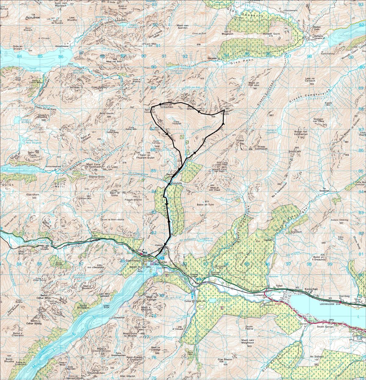
Location: The Corryhully Horseshoe, Inverness-shire
Grade: Strenuous hill walk
Distance: 12 miles/20km
Time: 6-8 hours
SOME folk call it the Glenfinnan Horseshoe, others call it the Corryhully Horseshoe, but the name doesn’t really matter. The two hills involved, Sgurr Thuilm (try hoolim) and Sgurr nan Coireachan always feel deliciously remote from tartan-clad Glenfinnan and its associated tourist trail. The Raising of the Standard in 1745 was the genesis of a sad, some would say ill-conceived, episode in Scotland’s history but the legend of Bonnie Prince Charlie shows that the Braveheart syndrome was alive and well in Glenfinnan long before Mel Gibson put on his woad and waggled his bare bum!
The West Highland Railway viaduct forms a massive gateway between the Tartanland and the long approach to what is some of the roughest hill country in Scotland. Sgurr Thuilm and Sgurr nan Coireachan could almost be refugees from a few miles north, for in terms of their rough and craggy slopes, their air of remoteness and views to the west, they are really Knoydart hills misplaced. There’s a small car park just off the A830 on the west side of the River Finnan in the shadow of the 21-span railway viaduct, a construction that’s been claimed, with some justification, as one of the great sights of the West Highlands - man-made sights that is.
Built in 1897, it was the world’s first significant mass-concrete structure. Isn’t it ironic that such a structure, built in one of the finest landscapes in the Highlands, should be made of concrete, that metaphor for urban decay, an unyielding, unforgiving material whose very name evokes the resonances of 1960s inner-city architecture? It seems that concrete was used because the local rock was so hard and difficult to dress. The builder, Robert McAlpine, was apparently very enthusiastic about concrete, pointing out to anyone who would listen that it did not rust, nor needed painting. Observant chap, and he probably richly deserved his nickname of ‘Concrete Bob’. There exists an apocryphal story about a horse and cart which had apparently fallen into one of the hollow piers of the viaduct, but according to a recent survey of the structure no trace of the unfortunate beast was revealed. However, it seems engineers have found some evidence that would suggest that old Dobbin didn’t fall into the Glenfinnan Viaduct supports, but those of the Loch nam Uamh viaduct several miles further west!
A track below the viaduct runs north, principally to service Glen Finnan Lodge, and continues to Corryhully bothy, idyllically positioned near the stream which drains the massive Coire Thollaidh and Coire a’ Bheithe. Higher up there used to be a wonderful rock pool where I’ve enjoyed more than one skinny dip. Alas it’s gone, an ugly bulldozed track has destroyed it.
Higher up you leave the track and the cascading stream for an obvious spur which leads onto a long ridge called Druim Coire a’ Bheithe - this is where the hard work begins. Grass-covered slopes lead to a small subsidiary top and then north to the summit of Sgurr Thuilm itself, at 963m, the Peak of the Round Hillock.
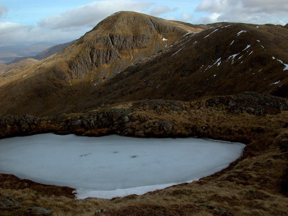
To the north-west the Knoydart hills fill the horizon, beyond the silver slash of lonely Loch Morar. Further east another silver slash, Loch Arkaig, gives way to the Loch Quoich hills. To the west Sgurr nan Coireachain, 956m, demands attention, a reasonable request because that’s the next destination, at the end of its wide, knobbled ridge, dotted with lochans and adorned by a line of old fence-posts that runs over the spine of the intermediate tops of Beinn Gharbh and Meall an Tarmachain, a rocky highway in the clouds.
Sgurr nan Coireachan may be slightly lower than Sgurr Thuilm but is aesthetically a much finer summit - the apex of a number of remote corrie ridges, craggy and wild. The final ridge to the summit cairn is narrow and rocky, with the depths of Coire Thollaidh dropping away on one side and the secretive flanks of Glen Pean on the other. From the summit rocky slopes tumble from your feet towards the head of Loch Morar and to your left the hill’s south-east ridge is steep and rocky and abuts on to steep cliffs which drop into Coire Thollaidh, a craggy place of immense character.
The ridge continues, in form and interest, across the minor top of Sgurr a’ Choire Riabhaich and down towards the River Finnan again. Drop off the ridge in an easterly direction to where a good stalker’s path skirts the foot of the crags to link up with the main track again. Return past Corryhully bothy and head back to Glenfinnan.
Cameron McNeish
ROUTE PLANNER
Map: OS Landranger sheet 40 (Mallaig & Glenfinnan)
Start/Finish: Glenfinnan (NM908807)
Distance: 12 miles/20km
Approx Time: 6-8 hours
Route: Take the private road/track N from the A830 road under the viaduct, pass Corryhully bothy and continue uphill to cross the stream which drains Coire Thollaidh and Coire a’ Bheithe. Climb NE to Druim Coire a’ Bheithe, then N to Sgurr Thuilm. From the cairn descend S for a short distance then turn W and walk over Beinn Gharbh and Meall an Tarmachain to the final slopes which lead to Sgurr nan Coireachan. Descend in a SE direction to Sgurr a’ Choire Riabhaich, then S down the ridge back to Corryhully and your outward track.
ALL WALKS ARE SUBJECT TO LOCAL RESTRICTIONS


Why are you making commenting on The Herald only available to subscribers?
It should have been a safe space for informed debate, somewhere for readers to discuss issues around the biggest stories of the day, but all too often the below the line comments on most websites have become bogged down by off-topic discussions and abuse.
heraldscotland.com is tackling this problem by allowing only subscribers to comment.
We are doing this to improve the experience for our loyal readers and we believe it will reduce the ability of trolls and troublemakers, who occasionally find their way onto our site, to abuse our journalists and readers. We also hope it will help the comments section fulfil its promise as a part of Scotland's conversation with itself.
We are lucky at The Herald. We are read by an informed, educated readership who can add their knowledge and insights to our stories.
That is invaluable.
We are making the subscriber-only change to support our valued readers, who tell us they don't want the site cluttered up with irrelevant comments, untruths and abuse.
In the past, the journalist’s job was to collect and distribute information to the audience. Technology means that readers can shape a discussion. We look forward to hearing from you on heraldscotland.com
Comments & Moderation
Readers’ comments: You are personally liable for the content of any comments you upload to this website, so please act responsibly. We do not pre-moderate or monitor readers’ comments appearing on our websites, but we do post-moderate in response to complaints we receive or otherwise when a potential problem comes to our attention. You can make a complaint by using the ‘report this post’ link . We may then apply our discretion under the user terms to amend or delete comments.
Post moderation is undertaken full-time 9am-6pm on weekdays, and on a part-time basis outwith those hours.
Read the rules here