
Location: Glenfinnan Corbetts
Lochaber
Grade: Serious mountain walk
Distance: 7 miles/12km
Ascent: 4,100ft/1,270m
Time: 6-8 hours
THE rocky bluffs and rugged landscape of northern Moidart have one big attribute above all others. There are no Munros here. That means no real footpaths to speak of, no erosion, no lines of cairns and no roadside car parks. Fewer people too – for the moment!
There are however, 10 very fine Corbetts – Scottish hills between 2,500ft and 2,999ft, named after their collater, John Rooke Corbett – and when you consider that these lower hills begin more or less at sea level, then you can get a good, hard day. This round of three Corbetts isn’t terribly far in terms of distance, only seven miles, but be prepared to climb in excess of 4,000 feet.
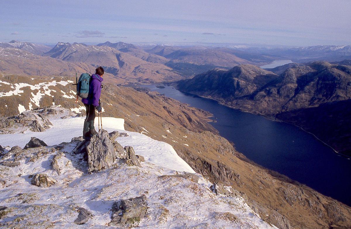
The memorial to the Raising of the Standard at Glenfinnan is a well-known spot, with the waters of Loch Shiel lapping the skirts of some big hills. On the northern shore rise two Corbetts, Beinn Odhar Bheag, 2,895ft/882m (small dun coloured hill) and Beinn Mhic Cedidh, 2,569ft/783m (MacCedidh’s hill) which, along with Beinn Odhar Mhor, 2,871ft/874m (big dun coloured hill) offers a very fine horseshoe round. Curiously, the small dun coloured hill is higher than its neighbour, the big dun coloured hill, obviously so named because of its smaller bulk. It’s good to remember that those who named these hills had little interest in their height above sea level – that appears to be a modern phenomenon.
Beinn Mhic Cedidh is the first Corbett to tackle. There’s a short walk through scattered birches alongside the West Highland railway, a climb up on to the cleft between the round lump of Sgurr na Paite and the foot of the hill’s north ridge by way of an easy gully, then a leisurely romp up the rocky, narrowing ridge itself. Choose a good day, as we did, and the views will simply blow your mind.
To the west lie two long parallel ridgelines – the slightly lower undulating ridge that runs from Croit Bheinn, and north of that the celebrated line of Corbetts that runs from the flat-topped Druim Fiaclach out to the beautiful conical shape of Rois-Bheinn. Beyond lie the blue waters of the Sound of Arisaig and the islands of Eigg, Rum and Skye.
The summit of Beinn Mhic Cedidh is marked by a tiny collection of rocks that curiously point the way to the next hill, Beinn Odhar Bheag. This is handily linked by a broad ridge and high bealach. Like me, you’ll be eager to catch a glimpse of the fjord-like Loch Shiel below and what a reward it is, steel-grey, narrow and stretched out from its head at Glenfinnan, cutting its way like a sword through some of the most rugged landscape in Scotland. Across its trench the other Corbetts of Moidart, Sgurr Ghiubhsachain, Sgorr Craobh a’ Chaorainn and Stob a’ Bhealach an Sgriodain rise from a rugged tableland of bluffs and hollows that gives way eventually to the tumbled landscape of Sunart.
A high level, rocky ridge connects Beinn Odhar Beag, the higher hill, to its bigger, but lower neighbour Beinn Odhar Mhor. Because this hill is easily seen from Glenfinnan, early guidebooks suggested this was the one you should climb. Indeed, an early SMC guide to the Western Highlands makes no mention at all of Beinn Mhic Cedidh, but that was published long before the present trend of Munro and Corbett-bagging.
As the list of those who have climbed all Scotland’s Munros has now topped 5,000, it’s a fair assumption that the Corbetts are going to become busier.
Until recently, these hills of Moidart have been one of Scotland’s best kept secrets. I doubt if they’ll stay quiet for much longer.
From Beinn Odhar Mhor a long curving ridge leads back towards Loch Eilt, the railway and the riverside walk back to the starting point.
Cameron McNeish
ROUTE PLANNER
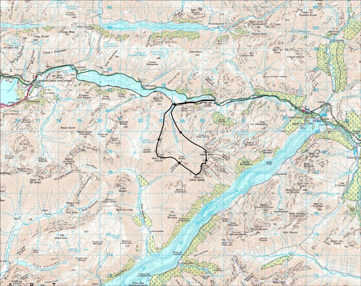
Map: OS 1:50,000 Landranger sheet 40 (Mallaig & Glenfinnan)
Distance: 7 miles/12km
Ascent: 4,100ft/1,270m
Time: 6-8 hours
Start/Finish: Car parking space on the A830, just over 1km E of Loch Eilt (GR: NM856813)
Information: Fort William TIC, 01397 701801
Route: From the parking space cross the Allt Lon a’Mhuidhe and walk beside the railway line W to the bridge over the Allt a’ Choire Bhuidhe. Cross the river (if you need to use the railway bridge take very great care) and climb the slopes which lead to the bealach at the foot of the N ridge of Beinn Mhic Cedidh. Follow this ridge to the summit. Descend E to the Bealach a’ Choire Bhuidhe and climb the NW ridge of Beinn Odhar Bheag to its summit. Follow the twisting N ridge now to Beinn Odhar Mhor then descend its NW ridge to the lower reaches of the Allt a’ Choire Bhuidhe. Cross the Allt a’ Choire Bhuidhe again and return to the starting point.
All walks are subject to local restrictions. This walk was first published in October 2017.


Why are you making commenting on The Herald only available to subscribers?
It should have been a safe space for informed debate, somewhere for readers to discuss issues around the biggest stories of the day, but all too often the below the line comments on most websites have become bogged down by off-topic discussions and abuse.
heraldscotland.com is tackling this problem by allowing only subscribers to comment.
We are doing this to improve the experience for our loyal readers and we believe it will reduce the ability of trolls and troublemakers, who occasionally find their way onto our site, to abuse our journalists and readers. We also hope it will help the comments section fulfil its promise as a part of Scotland's conversation with itself.
We are lucky at The Herald. We are read by an informed, educated readership who can add their knowledge and insights to our stories.
That is invaluable.
We are making the subscriber-only change to support our valued readers, who tell us they don't want the site cluttered up with irrelevant comments, untruths and abuse.
In the past, the journalist’s job was to collect and distribute information to the audience. Technology means that readers can shape a discussion. We look forward to hearing from you on heraldscotland.com
Comments & Moderation
Readers’ comments: You are personally liable for the content of any comments you upload to this website, so please act responsibly. We do not pre-moderate or monitor readers’ comments appearing on our websites, but we do post-moderate in response to complaints we receive or otherwise when a potential problem comes to our attention. You can make a complaint by using the ‘report this post’ link . We may then apply our discretion under the user terms to amend or delete comments.
Post moderation is undertaken full-time 9am-6pm on weekdays, and on a part-time basis outwith those hours.
Read the rules here