

Location: Bynack More, Cairngorms
Grade: Serious mountain walk
Distance: 12 miles/20km
Time: 6-8 hours
BYNACK More is my ‘bad weather’ hill. Lying to the east of the main Cairngorms massif, this 1090m/3576ft Munro tends to benefit from the bigger hills’ rain shadow and on days when the western Cairngorms are being drenched with rain it’s surprising how often Bynack More remains relatively dry.
On windy days it pays to be a little more circumspect. Theoretically you’d assume that the powerful bulk of Cairn Gorm itself would protect its smaller neighbour but theory, however sound it may be, doesn’t always work in the mountains, as we were to discover.
With the Feshie hills and Braeriach swathed in a dark, ominous layer of cloud, my brother-in-law and I drove the length of Glen More and parked the car near Glenmore Lodge. We began walking, through the lovely Pass of Ryvoan, in dry and bright conditions and it wasn’t until we reached the River Nethy that we noticed the wind.
The track we were on followed the course of one of the Cairngorm ‘mounth roads’ or passes, the Lairig an Laoigh, which runs from Abernethy in the north to Braemar in the south. Both this pass and its parallel neighbour, the Lairig Ghru, were once droving routes resounding to the movement of cattle. Indeed Lairig an Laoigh can be translated as ‘pass of the stirks, or calves’. It must have been a long haul for the cattle as they climbed from the comparatively fertile basin of the River Nethy to the scree-girt high ground which forms the skirt of Bynack More itself.
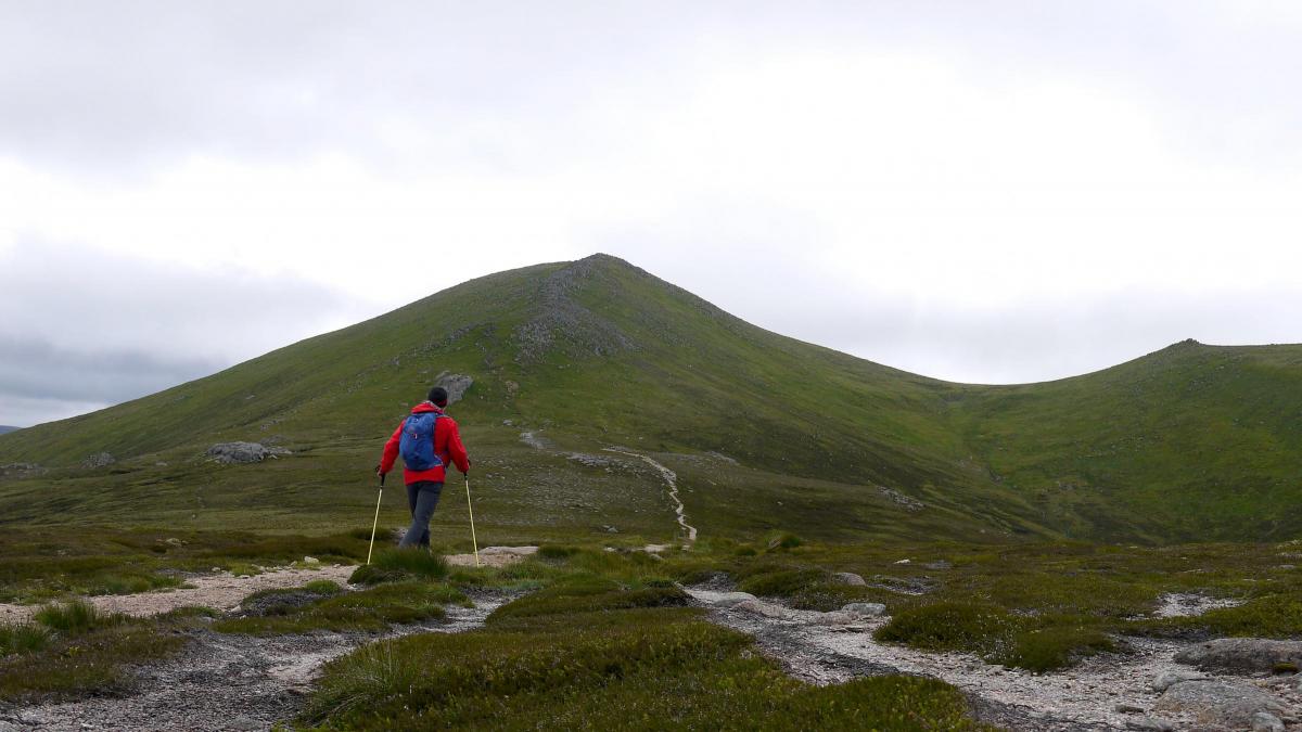
This grand hill stands apart from its loftier, more popular neighbours, as though keen to emphasise its individuality and gritty character, despite its inferior height and mass. Bynack More’s finest features tend to be more subtle, less glaringly elephantine, than its immediate neighbours, and it exhibits its finest face to the north above the Forest of Abernethy. From here it appears as a fine conical peak, steep slopes rising smoothly to a narrow crest, a direct contrast to the tor-studded whaleback of distant Ben Avon and the leviathan mass of Cairn Gorm itself. Bynack More is divided by a large, high level grassy depression into two distinct rocky summits. On its western shoulder lies a subsidiary top known as Bynack Beg. The main summit was at one time known as Ben Bynack but the late Rev. W Forsyth of Abernethy, al ocal historian, suggests this is wrong and Bynack derives from Ben-Eag, the hill of the cleft, a nick between the summit rocks, which you can see from Strath Nethy. Other Gaelic scholars suggest the word comes from ‘beinneag’, little mountain (compared to its neighbours even Bynack More, the big Bynack, is a little mountain) or even from Am Beidhneag, a chimneypot or roof-ridge. It didn’t take us long to realise we were in for a battle. Despite a couple of light showers the cloud level remained above the summits but it was the wind that was to prove challenging. As we approached the main ridge a couple of violent gusts almost stopped us in our tracks and by the time we climbed up the rocky ridge it was apparent that we would have to take great care simply to remain rooted to the ground.
The wind was coming from the south-west, so, just as Cairn Gorm protects Bynack More from the worst of the westerly gales we reckoned we could use the summit ridge of Bynack More to protect us. It worked! We traversed across the slopes above Coire Odhar in relative calm and it was only when we dared pop our heads over the ridge that we felt the full demonic fury of the wind.
The summit cairn was, of course, fully exposed to the gales and was no place to linger, so we retreated back into the shelter of our eastern slopes and stopped for lunch. There was a slight disappointment that we had to return by our outward route rather than continuing over A’Choinneach to The Saddle from where we could have climbed Cairn Gorm itself. The Saddle, above the foot of Loch Avon, confronts one of the wildest views in Scotland, with steep granite slab slopes dropping down to cradle the grey waters of Loch Avon. At the head of the loch rises the improbably square-cut face of The Sticil, like a massive tomb stone set amongst the high plateaux that surround it.
A traversing path climbs the steep slopes from The Saddle at the head of Strath Nethy to Ciste Mearaid and from there it’s an easy descent either by Cairn Gorm’s north ridge to Ryvoan, or by way of the Sron an Aonaich ridge and the Allt Mor footpath back to Glenmore.
Cameron McNeish
ROUTE PLANNER
Map: OS 1:50,000 Landranger sheet 36 (Grantown & Aviemore); Harveys 1:40,000 British Mountain Map, The Cairngorms and Lochnagar.
Distance: 12 miles/20km.
Time: 6-8 hours.
Start/Finish: Glenmore Lodge (GR: NH 992097).
Public transport: Hourly bus no 31 from Aviemore to Glen More. Details from www.travelinescotland.com
Information: Aviemore TIC, 01479 810930.
Route: Leave the parking area beyond Glenmore Lodge and follow the forestry track into the Pass of Ryvoan. Continue through the Pass, past An Lochan Uaine. About 400m beyond the lochan take another path E to Bynack Stable and the River Nethy. Cross the river and follow the footpath SE over the lower shoulder of Bynack More. Follow this path to its highest point then leave it to bear S up the N ridge to the summit. Return the same way or, if conditions allow, continue over A’Choinneach to the Saddle and climb Cairn Gorm by a good ascending traverse path. From there follow the Sron Aonaich ridge back to Glenmore.
All walks are subject to local restrictions. This walk was first published in May 2019.


Why are you making commenting on The Herald only available to subscribers?
It should have been a safe space for informed debate, somewhere for readers to discuss issues around the biggest stories of the day, but all too often the below the line comments on most websites have become bogged down by off-topic discussions and abuse.
heraldscotland.com is tackling this problem by allowing only subscribers to comment.
We are doing this to improve the experience for our loyal readers and we believe it will reduce the ability of trolls and troublemakers, who occasionally find their way onto our site, to abuse our journalists and readers. We also hope it will help the comments section fulfil its promise as a part of Scotland's conversation with itself.
We are lucky at The Herald. We are read by an informed, educated readership who can add their knowledge and insights to our stories.
That is invaluable.
We are making the subscriber-only change to support our valued readers, who tell us they don't want the site cluttered up with irrelevant comments, untruths and abuse.
In the past, the journalist’s job was to collect and distribute information to the audience. Technology means that readers can shape a discussion. We look forward to hearing from you on heraldscotland.com
Comments & Moderation
Readers’ comments: You are personally liable for the content of any comments you upload to this website, so please act responsibly. We do not pre-moderate or monitor readers’ comments appearing on our websites, but we do post-moderate in response to complaints we receive or otherwise when a potential problem comes to our attention. You can make a complaint by using the ‘report this post’ link . We may then apply our discretion under the user terms to amend or delete comments.
Post moderation is undertaken full-time 9am-6pm on weekdays, and on a part-time basis outwith those hours.
Read the rules here