
Location: Sgurr Gaorsaic, Kintail
Grade: Moderate mountain walk
Distance: 9miles/14km
Time: 6-8 hours
SGURR Gaorsaic is a Corbett surrounded by giants. To the west the big Munros of A’ Ghlas-bheinn and the corrie-bitten Beinn Fhada dominate the views while to the east Sgurr nan Ceathreamhnan, a real tongue-twister of a hill, is joined at the hip, so to speak, by a high bealach just south of Coire Thuill Easaich.
That parent hill, Sgurr nan Ceathreamhnan (try skoor nan keroanan), has a reputation for remoteness. Indeed, the Munro-bagging legend Hamish Brown once suggested a friend of his left instructions for his pals to scatter his ashes on this mountain so they can enjoy a good, long mountain walk. Thoroughly decent of him…
Sgurr Gaorsaic is really no more than a western top of Ceathreamhain but, because the bealach that connects them is more than 500 feet below the summit of Gaorsaic, the hill qualifies as a Corbett, one of Scotland’s hills between 2500ft and 2999ft. But while it comfortable qualifies as a Corbett, is only just qualifies as a Sgurr. This Gaelic word translates as a sharp, rocky hill or rocky peak and Sgurr Gaorsaic is anything but that. Indeed, it’s a comparatively dumpy, flat-topped hill with some rocky stretches on its north-east and western slopes – enough rock, apparently, to qualify it as a Sgurr.
Slightly disparaging as these comments may be, the ascent of Sgurr Gaorsaic, which curiously translates as “peak of horror” or “peak of thrills”, is noteworthy because it necessitates a walk through the superb Bealach an Sgairne, the pass “where the stones make noise”. That loose interpretation of the Gaelic refers to the wind sighing or murmuring through the rocks, as well as the sound of falling rocks.
Bear that in mind if you hear any strange sounds, for apparitions have been experienced here too. On the trail that winds its way up from Strath Croe in the west, some walkers once passed a tall, thin man with a white beard, hand in hand with a small girl wrapped up in a cloak and a hood. After making local inquiries they were convinced they had met the ghosts of Osgood Mackenzie, the great botanist and creator of Inverewe Gardens, and his daughter Mhairi. Mackenzie had died some 30 years previously.
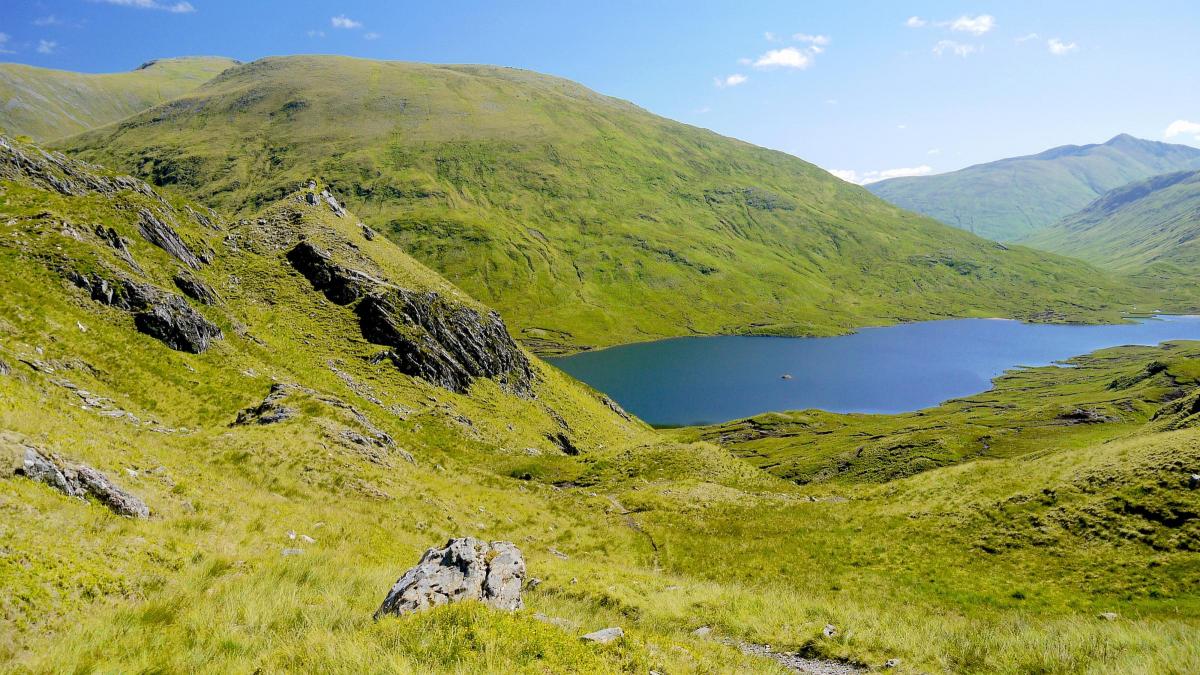
Spectral apparitions apart, I think this is one of the finest passes in the country. An excellent footpath runs up from Strath Croe in Kintail and soon the hillsides loom in on both sides of you as you enter Gleann Choinneachain. Rocky slopes tumble down from A’Ghlas-bheinn in the north and from Coire an Sgairne in the south, from where a subsidiary footpath climbs through the corrie to the summit slopes of the Munro, Beinn Fhada. Now the footpath has to squeeze through the narrow gap ahead, and descend into broad Gleann Gaorsaic with its lochs and burns that feed the main river, watercourses that drain the slopes of the big mountains. All that water is harnessed into a single stream and then directed into a narrow, rocky cleft about 5km to the north – the Falls of Glomach, where it plunges for some 130 metres, twice the height of Niagara, into a deep, black chasm.
The Bealach an Sgairne, known as the Gates of Affric, is like a portal into another world, a beautiful place formed by the dogleg where Gleann Gaorsaic and Gleann Gniomhach meet. The green slopes of Sgurr Gaorsaic rise in the cleft of that dogleg and its flat-topped summit is dominated by the south ridge of Sgurr nan Ceathreamhnan.
The route to Sgurr Gaorsaic crosses some waterlogged ground and skirts the south banks of Loch a’Bhealaich. It then joins up with another footpath that continues east to the Youth Hostel at Alltbeithe and Glen Affric but, half a kilometre or so after leaving the loch, you have to leave the footpath and climb the steep grassy south slopes of Sgurr Gaorsaic.
It’s not a big climb – most of the hard work has been completed in the ascent to the Bealach na Sgairne – and as you wander across the summit plateau towards the spiky cairn you’ll find yourself gasping at the beauty of the views and the big hills that surround you.
CAMERON McNEISH
ROUTE PLANNER
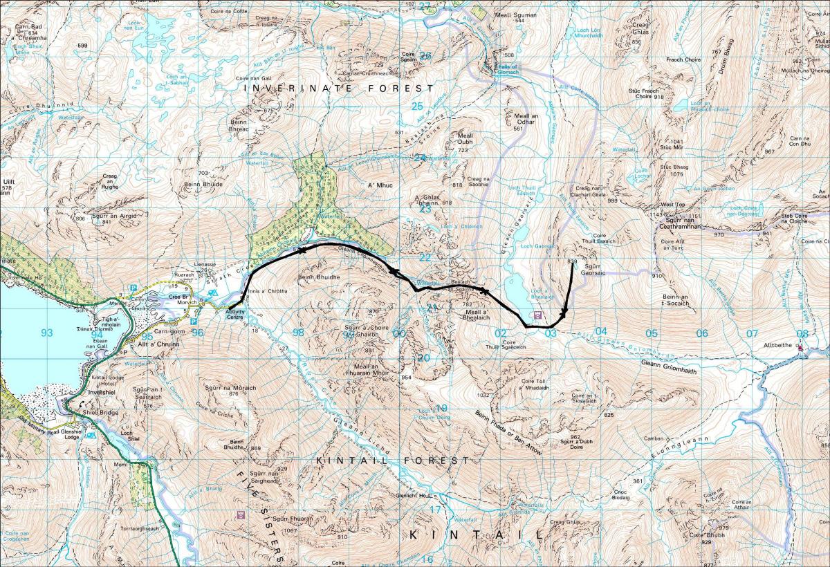
Map: OS 1:50,000 Landranger sheet 33 (Loch Alsh, Glen Shiel & Loch Hourn). Harvey Mountain Map, Knoydart, Kintail & Glen Affric
Distance: 9 miles/14km
Approx Time: 6-8 hours
Start/Finish: Morvich Countryside Centre, off A87 near Shiel Bridge (GR: NG961211
Information: Morvich Countryside Centre, 01599 511231
Route: Cross the footbridge and follow the signs to Falls of Glomach. Leave Strath Croe behind and enter Gleann Choinneachain, ignoring the Falls of Glomach sign that points to the left. Follow the path all the way to the Bealach an Sgairne. Go through the pass and descend to the S end of Loch a’Bhealaich. Once past the loch, climb the S slopes of Sgurr Gaorsaic to the level summit. The cairn lies at the N end of the plateau. Return by the same route.
Due to current restrictions, we are running our favourite previously published walks. Please follow the Scottish Government’s coronavirus restrictions, see www.gov.scot/ coronavirus-covid-19


Why are you making commenting on The Herald only available to subscribers?
It should have been a safe space for informed debate, somewhere for readers to discuss issues around the biggest stories of the day, but all too often the below the line comments on most websites have become bogged down by off-topic discussions and abuse.
heraldscotland.com is tackling this problem by allowing only subscribers to comment.
We are doing this to improve the experience for our loyal readers and we believe it will reduce the ability of trolls and troublemakers, who occasionally find their way onto our site, to abuse our journalists and readers. We also hope it will help the comments section fulfil its promise as a part of Scotland's conversation with itself.
We are lucky at The Herald. We are read by an informed, educated readership who can add their knowledge and insights to our stories.
That is invaluable.
We are making the subscriber-only change to support our valued readers, who tell us they don't want the site cluttered up with irrelevant comments, untruths and abuse.
In the past, the journalist’s job was to collect and distribute information to the audience. Technology means that readers can shape a discussion. We look forward to hearing from you on heraldscotland.com
Comments & Moderation
Readers’ comments: You are personally liable for the content of any comments you upload to this website, so please act responsibly. We do not pre-moderate or monitor readers’ comments appearing on our websites, but we do post-moderate in response to complaints we receive or otherwise when a potential problem comes to our attention. You can make a complaint by using the ‘report this post’ link . We may then apply our discretion under the user terms to amend or delete comments.
Post moderation is undertaken full-time 9am-6pm on weekdays, and on a part-time basis outwith those hours.
Read the rules here