
Location: Sutherland
Grade: Serious mountain walk
Distance: 6 miles/10km
Time: 3-5 hours
WE had retreated to the far north-west for a few days with a hitlist of hills we wanted to climb, lonely beaches to explore and a disposable barbecue in the boot.
The hills, as always, didn’t disappoint and neither did the beaches but a barbecue doesn’t have quite the same appeal when you’re wrapped up in waterproofs and a balaclava.
We had approached the watery wilderness of the Reay Forest from Lairg, then along the empty miles beside Loch Shin where man-made islands are used as nesting platforms by black-throated divers. Water run-off from the hills, due to overgrazing and forestry, has increased in recent years and the traditional nesting islands are often flooded.
The artificial islands rise and fall with the water level. Breeding numbers have been successful and the bird’s melancholy call seems to embody the spirit of these northern parts.
The great Highland writer Seton Gordon once described the wild and compelling cry as one that might come from “one of the uruisgean or gruagachan which in tradition and folk-lore people those sea-girt isles”.
It’s an eerie sound in the half-light of a late summer evening, especially if you’re camped by a remote hill loch.
Ben Stack wasn’t on our list but since we were passing it
en route to Laxford Bridge and Durness we reckoned it would make a good warm-up.
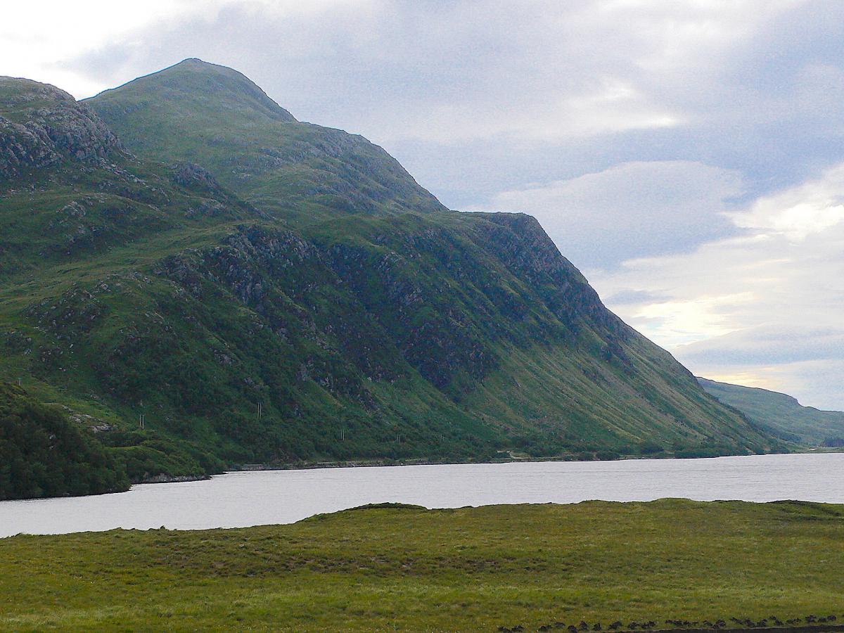
At 721 metres it falls short of Corbett status but I had admired it often enough, a rocky, conical and isolated peak that rises from the shores of Loch Stack in two steep bands of cliff-line.
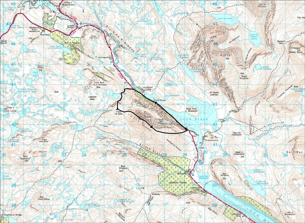
Its blunt, western nose is steep too, but beyond its roof-like summit ridge its south-eastern slopes fall away in a gentle and rounded ridge, the Leathad na Stioma. Footpaths curve their way round the west and south of the hill and the A838 hugs the shoreline of Loch Stack below its western cliffs, offering alternative circular routes.
We decided to tackle the steep west-facing nose first, before ambling down the Leathad na Stioma ridge with the wind at our back, returning to the car along the quiet road. Having just returned from the Western Isles we’d endured more than our fill of boggy footpaths.
A well-maintained stalker’s path zig-zags its way from the road up to Loch na Seilge. From there it was simply a matter of getting the head down and plodding upwards through the rocky outcrops to the summit ridge.
Mist spoiled the chance of far-flung views but created a micro-world for us to climb through, a dark world of exaggerated form where distance, height and steepness always felt out of context, no more so than on the knife-edge summit ridge.
In good visibility this would be a pleasant amble, but in the wind and thick mist it felt exposed and dangerous.
A sudden thinning of the mist put things in better perspective and made us feel a little silly – the tightrope ridge was no more than a narrow rib with flat turf below.
The 721m summit cairn was directly in front of us and a hundred metres beyond lay the trig point and what looked like a television mast! The descent was kinder to us in terms of views – out along Loch More and Loch Shin and the wonderfully named Meallan Liath Coire Mhic Dhughaill and northwards to Arkle, Meall Horn and Foinaven.
The sounds of black-throated divers, echoing from Loch Stack, made the 3km tarmac tramp back to the car more than worth it.
CAMERON McNEISH
Map: OS 1:50,000 Landranger sheet 9 (Cape Wrath)
Distance: About 6 miles/10km
Approx Time: 3-5 hours
Start/Finish: A838 road near the turn-off to Lochstack Lodge (GR: NC265438)
Route: Leave the road and follow a stalker’s path to Loch na Seilge. Beyond the loch leave the path and follow a line of fence posts up steep grass and heather slopes to a broad terrace from where the west ridge of Ben Stack becomes steeper in a series of rocky outcrops and grassy terraces. Make your way up through the ribs and crags on ever-steeper ground being careful to avoid the much craggier N slopes of the hill. Once the summit ridge is reached follow it for a short distance to the cairn. The trig point lies further along, on another rib. From here climb a small knoll then begin to descend the hill’s broad and grassy SE ridge. If you are returning to the starting point by the road don’t descend N too quickly as steep cliffs fall directly to the roadside but instead take a SE then an E line until you are close to the road at the SE end of Loch Stack. Alternatively you could descend SE then S to the woods above Achfary then follow the stalker’s path NW then N back to Loch na Seilge.


Why are you making commenting on The Herald only available to subscribers?
It should have been a safe space for informed debate, somewhere for readers to discuss issues around the biggest stories of the day, but all too often the below the line comments on most websites have become bogged down by off-topic discussions and abuse.
heraldscotland.com is tackling this problem by allowing only subscribers to comment.
We are doing this to improve the experience for our loyal readers and we believe it will reduce the ability of trolls and troublemakers, who occasionally find their way onto our site, to abuse our journalists and readers. We also hope it will help the comments section fulfil its promise as a part of Scotland's conversation with itself.
We are lucky at The Herald. We are read by an informed, educated readership who can add their knowledge and insights to our stories.
That is invaluable.
We are making the subscriber-only change to support our valued readers, who tell us they don't want the site cluttered up with irrelevant comments, untruths and abuse.
In the past, the journalist’s job was to collect and distribute information to the audience. Technology means that readers can shape a discussion. We look forward to hearing from you on heraldscotland.com
Comments & Moderation
Readers’ comments: You are personally liable for the content of any comments you upload to this website, so please act responsibly. We do not pre-moderate or monitor readers’ comments appearing on our websites, but we do post-moderate in response to complaints we receive or otherwise when a potential problem comes to our attention. You can make a complaint by using the ‘report this post’ link . We may then apply our discretion under the user terms to amend or delete comments.
Post moderation is undertaken full-time 9am-6pm on weekdays, and on a part-time basis outwith those hours.
Read the rules here