
Location: Port Appin, Argyll
Grade: Easy coastal and woodland walk
Distance: 1.5 miles/2.5km
Time: 1-2 hours
VISITORS to the Appin area will be familiar with the iconic view of Castle Stalker, set on its tiny islet in Loch Laich. Dating to the 15th century, Castle Stalker was taken by the Campbells in 1620, before being recaptured by the Stewarts after a siege in 1685. Restoration work in recent years have made Castle Stalker one of the most familiar and best loved sights in this area of Scotland.
The district of Appin is bounded to the west by Loch Linnhe, to the south by Loch Creran, to the east by the districts of Benderloch and Lorne, and to the north by Loch Leven. The name means ‘abbey land’ and there is a lovely short walk around a small peninsula on the western extremity of the area, giving wonderful views across the Lynn of Lorn to Lismore and beyond to the hills of Morvern.
The coastline around Appin and Benderloch is incredibly convoluted but we set out on this walk on a beautiful summer’s day and knew it was a straightforward circuit. There’s little danger of getting lost here.
Port Appin in summer always gives the impression of being really busy, but the packed car park is invariably full of cars belonging to people who have taken the pedestrian-only ferry across to Lismore. Once you walk beyond the car park and hotel you’re likely to have this walk to yourself.
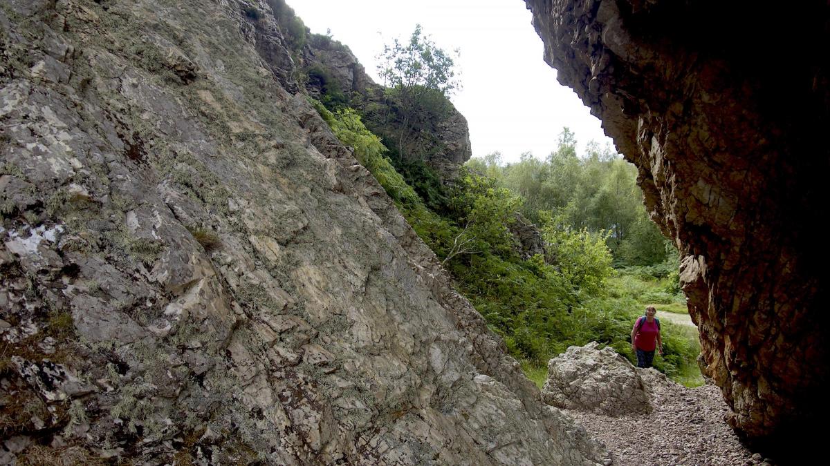
Behind the hotel a signpost points the way to Clach Thoull and the obvious track passes through a gate. Even at this early stage the views across to Morvern are inspiring. With steep cliffs on one side and a rocky coastline on the other the track meanders along towards a large rock arch. Incredibly this was formed by erosion before the sea level fell. You’ll probably want to walk through it to meet the track on the other side, but before you do that take a wander down through the bracken to the raised beach below. The coastline here is rocky and rugged and the seabound views are dramatic.
We wandered back to the arch and continued along the track, which now began to follow the north shore of Airds Bay, a place that is usually alive with waders at times of low tide. To the sound of curlews and sandpipers we strolled through the woods that were alive with the sound of chaffinches.
A house signalled the end of the track and a signpost showed the way to Port Appin – round the far side of the house where a path ran through the woodland beside a fence. Soon we went through a gate onto the minor road that would take us back to the car park.
We stopped at Port Appin village hall to have a look at the display of old lighthouse lanterns. There is a lot of information here about Port Appin’s history so it’s well worth while a stop. Unable to resist a morning coffee, we also stopped at one of the two shops for a brew before the final short stretch back to the car park at the end of a truly lovely walk.
Cameron McNeish
ROUTE PLANER
Map: OS 1:50,000 Landranger sheet 49 (Oban & East Mull); 1:25,000 Explorer sheet 376 (Oban & North Lorn).
Distance: 1.5 miles/2.5km
Time: 1-2 hours
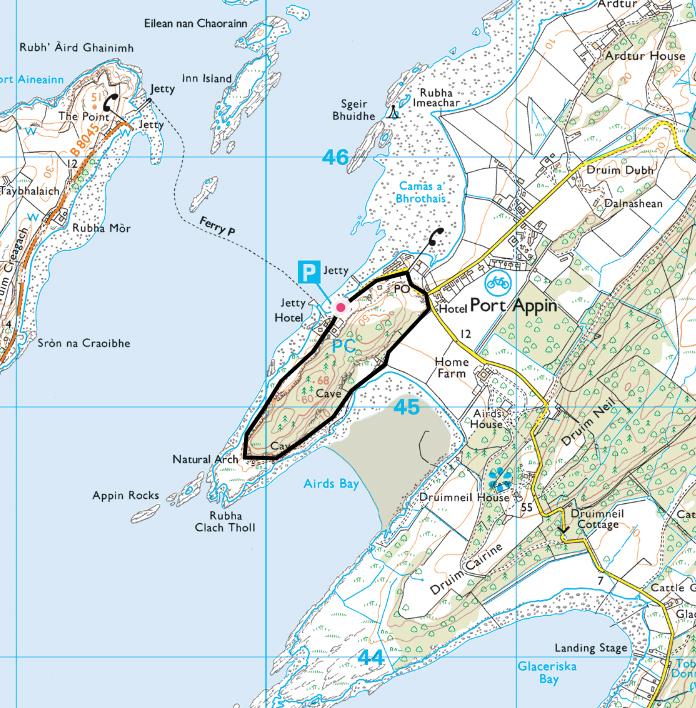
Start/Finish: Car park in Port Appin (GR: NM903454).
Public transport: None to the start.
Information: Oban TIC, 01631 563122, www.argyll-bute.gov.uk/tourism
Route: Leave the car park behind the Pierhouse Hotel and follow the footpath around the R side of a house. Go through a gate and continue on the track with cliffs on one side and the shoreline on the other. Pass, or go through, the obvious arch and continue on the track as it curves away from the sea and along the N shore of Airds Bay. When you reach a house, follow signpost to Port Appin round the far side of the house and follow footpath that runs between the woodland and a fence. Go through a gate onto a minor road, turn L and follow road back to Port Appin, ignoring a road that comes in from the R.


Why are you making commenting on The Herald only available to subscribers?
It should have been a safe space for informed debate, somewhere for readers to discuss issues around the biggest stories of the day, but all too often the below the line comments on most websites have become bogged down by off-topic discussions and abuse.
heraldscotland.com is tackling this problem by allowing only subscribers to comment.
We are doing this to improve the experience for our loyal readers and we believe it will reduce the ability of trolls and troublemakers, who occasionally find their way onto our site, to abuse our journalists and readers. We also hope it will help the comments section fulfil its promise as a part of Scotland's conversation with itself.
We are lucky at The Herald. We are read by an informed, educated readership who can add their knowledge and insights to our stories.
That is invaluable.
We are making the subscriber-only change to support our valued readers, who tell us they don't want the site cluttered up with irrelevant comments, untruths and abuse.
In the past, the journalist’s job was to collect and distribute information to the audience. Technology means that readers can shape a discussion. We look forward to hearing from you on heraldscotland.com
Comments & Moderation
Readers’ comments: You are personally liable for the content of any comments you upload to this website, so please act responsibly. We do not pre-moderate or monitor readers’ comments appearing on our websites, but we do post-moderate in response to complaints we receive or otherwise when a potential problem comes to our attention. You can make a complaint by using the ‘report this post’ link . We may then apply our discretion under the user terms to amend or delete comments.
Post moderation is undertaken full-time 9am-6pm on weekdays, and on a part-time basis outwith those hours.
Read the rules here