
Location: Bla Bheinn, Isle Of Skye
Grade: Serious mountain walk
Distance: 8 miles/13km
Time: 6-8 hours
AFTER fifty-two continuous days of rain on the Isle of Skye, the old Celtic Gods smiled kindly on us as we set off from the rough track between the Broadford to Elgol road and Camasunary.
I’d been making sporadic visits to the Misty Isle a few summers ago to make a documentary for the BBC and we’d been plagued by the weather, so much so that I was considering writing a guide to Skye’s cafes and coffee shops. But on this day we were blessed with that early autumn vibrancy that follows a frosty night and a clear sky. As we topped the low rise above the lovely bay of Camasunary the south ridge of Bla Bheinn rose to the sky in a series of rocky steps.
I was in the company of Alistair MacPherson, at the time the local land manager for the John Muir Trust, who own about 12,500 hectares in this part of Skye. He was telling me of the work he had been doing taking sheep off Bla Bheinn to allow regeneration of plants and woodland. He remained true to the party line but I suspected such an action must have caused a hint of remorse in someone whose grandfather was a shepherd on Skye in the early years of last century.
If he had any regrets Alistair didn’t show it but instead took delight in showing me some of the plants on the hill that, after years of browsing by sheep, are flourishing again. Better still he took my arm at one point, pointed upwards and said those magic words – golden eagle! This was the first of three golden eagles we were to see and this one was intent on showing off. It would spiral high then close its wings together and drop through the air like a stone, before spreading its wings again into another glide and upwards spiral.
The south ridge of Bla Bheinn not only offers a great route to the south summit of the mountain, it avoids the endless screes of the usual Munro-baggers route from Coire Uaigneich. It’s a dozen years or so since I last climbed this route and I was amazed how the path has developed, although I’m not surprised by its evident popularity. The views across to the Black Cuillin are astonishing – Alastair, a Skye man born and bred commented on its Tolkienesque quality and he was right, nowhere else in all the mountain regions of the UK can you witness such savage grandeur.
Bla Bheinn, 929m/3045ft, is the most southerly of the Red Cuillin and not only offers a splendid platform from which to gasp at the audacious outline of the Black Cuillin but also gives you the opportunity to appreciate the subtler curves of their pink-red neighbours. On a day of gusting winds and racing clouds I once struggled up the eastern ridge and broke the skyline just as the wind tore a great gash in the clouds. Through that hole the sharp, tortured peaks of the Cuillin appeared as crooked remnants of some hyperborean wilderness and through the roar of the wind I could hear something else. It was the cacophony of geese. Their music was clear, blending with the wind into a natural melody that had me trembling in delight.
Alastair and I reached the south summit in surprisingly quick time and saw the north summit, the true summit, only a short distance away. However, getting there is not straightforward. Between the two summits is a deep chasm, and the descent and ascent to the main summit involved a rough scramble, a fairly delicate traverse on wet rock and another short, but steep, climb to the summit cairn and trig point. Indeed, you have to do it twice for the best descent route from the mountain is down the slopes of the south peak to where a very eroded footpath takes you down to Coire Uaigneich and the path back to the John Muir Trust car park on the shore of Loch Slapin where we had left a car earlier.
For those who don’t have the advantage of two cars, you can return to the Camasunary track by following the Abhainn nan Leac from the bealach at the head of Coire Uaigneich.
Cameron McNeish
ROUTE PLANNER
Map: OS 1:50,000 Landranger sheet 32 (South Skye & Cuillin Hills); Harvey 1:25,000 Superwalker, The Cuillin
Distance: About 8 miles/13km
Approx Time: 6-8 hours
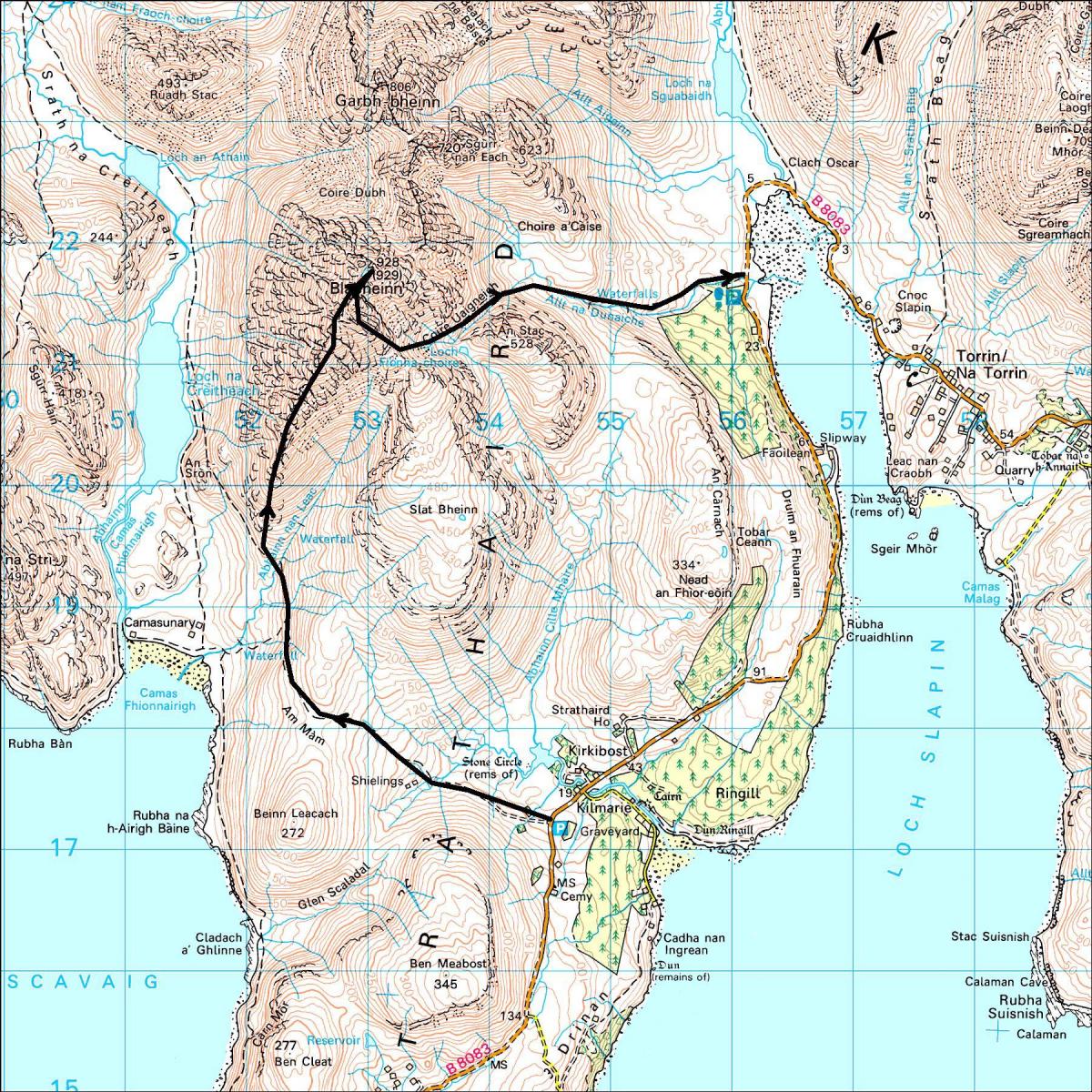
Start: Car park on B8083 Elgol road just S of Kilmarie (GR: NG545172)
Finish: Car park on B8083 near the head of Loch Slapin (GR: NG562215)
Public transport: None to the start
Information: Portree TIC, 01478 614906, www.isleofskye.com
Route: Follow the track that runs W then N to Camasunary. At a junction of paths continue N towards the S ridge of Bla Bheinn. Cross the Abhainn nan Leac and climb onto the S ridge. Follow ridge to S summit. Cross deep defile between the two summits by descending a short distance down a scree filled gully then traversing N to reach a narrow col. Climb to main summit and trig point. Return to S summit and descend SE down scree-covered slopes. Head NE into Coire Uaigneich and follow the eroded path down to the Allt na Dunaiche from where the path improves significantly all the way back to the Elgol road near the head of Loch Slapin.


Why are you making commenting on The Herald only available to subscribers?
It should have been a safe space for informed debate, somewhere for readers to discuss issues around the biggest stories of the day, but all too often the below the line comments on most websites have become bogged down by off-topic discussions and abuse.
heraldscotland.com is tackling this problem by allowing only subscribers to comment.
We are doing this to improve the experience for our loyal readers and we believe it will reduce the ability of trolls and troublemakers, who occasionally find their way onto our site, to abuse our journalists and readers. We also hope it will help the comments section fulfil its promise as a part of Scotland's conversation with itself.
We are lucky at The Herald. We are read by an informed, educated readership who can add their knowledge and insights to our stories.
That is invaluable.
We are making the subscriber-only change to support our valued readers, who tell us they don't want the site cluttered up with irrelevant comments, untruths and abuse.
In the past, the journalist’s job was to collect and distribute information to the audience. Technology means that readers can shape a discussion. We look forward to hearing from you on heraldscotland.com
Comments & Moderation
Readers’ comments: You are personally liable for the content of any comments you upload to this website, so please act responsibly. We do not pre-moderate or monitor readers’ comments appearing on our websites, but we do post-moderate in response to complaints we receive or otherwise when a potential problem comes to our attention. You can make a complaint by using the ‘report this post’ link . We may then apply our discretion under the user terms to amend or delete comments.
Post moderation is undertaken full-time 9am-6pm on weekdays, and on a part-time basis outwith those hours.
Read the rules here