
Location: Beinn Mhanach
Breadalbane
Grade: Moderate but long mountain walk
Distance: 14 miles/22km
Approx Time: 8-9 hours
An Awkward Munro
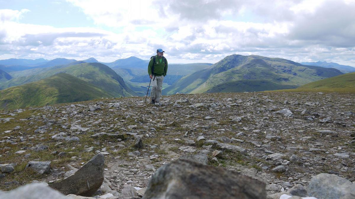
THE hill of the monk, Beinn Mhanach (3130 ft/954m) is generally considered as one of the Bridge of Orchy Munros but it’s universally cursed by Munro-baggers because of its awkward position.
This hill lies in the grasp of Beinn Dorain, Beinn an Dothaidh, Beinn Achaladair and Beinn a'Chreachain, hills that collectively form the graceful curve of mountains known as the Wall of Rannoch. Beinn Mhanach lies in the hollow of that curve and you can’t really add it to an ascent of the others without a big descent and re-ascent. Having said that, I’ve always thought it’s better climbed on its own, either as an out-and-back from Bridge of Orchy, as I did a number of years ago on skis, or as part of a longer circular walk that also takes in the old Clan Macgregor coffin route between Glen Lyon and the Auch Gleann.
That ski trip was memorable. Taff Bowles, an old pal who is now director of Outdoor Education for Yorkshire, and I skied in from Bridge of Orchy over the bealach between Beinn Dorain and Beinn an Dothaidh. Deep snow gave us good running down to the very head of the Auch Gleann from where we cut round into the head of Gleann Cailliche. A long rising traverse took us to the shallow col between the two tops and from there it was an easy glide to the summit of Beinn Mhanach.
This time I took the familiar track that climbs from Bridge of Orchy station up to that high bealach, a track that is eroding fast, testament to the popularity of these Bridge of Orchy Munros. As I dropped down the wet grassy slopes towards the head of Auch Gleann I realised I’d forgotten how long a pull it would be to come back out the same way. I’d be better returning to Bridge of Orchy via the Auch Gleann itself but I really didn’t fancy the 5km walk back along the busy A82 dodging cars, buses and caravans. It wasn’t until I took a wee break and had a look at the map that I remembered the West Highland Way.
How could I have forgotten it? The route parallels the West Highland rail line between Auch and Bridge of Orchy, giving easy, and flat, walking at the end of the day. I was delighted by the realisation that I wouldn’t have to climb back up to the high bealach between Beinn Dorain and Beinn an Dothaith and descend the very muddy and eroded path back to Bridge of Orchy.
With the day’s plan in hand the rest of the climb was a delight, with the views growing in scale as I climbed higher up the steep slopes of Beinn a’ Chuirn, the western top of Beinn Mhanach. Just over a kilometre of easy walking separates the two tops, a delightful stroll with great views in every direction. All the Crianlarich hills stood out clear, Ben Lui was visible down the length of the winding Allt Kinglass and closer at hand Beinn Dorain and Beinn an Dothaidh showed off uncharacteristic traits that you don’t see from the A82 side – steep and rugged north and east facing corries.
I decided to drop down the south side of the hill on steep grassy slopes that had me slithering on my backside several times. I was on the Glen Lyon track in just over an hour. The track follows part of an old coffin route once used by the MacGregors as they walked through from Glen Lyon to bury their dead in the graveyard at Auch. Some way down Auch Gleann I passed the sheep fank on the sitez of the home of the Gaelic poet Duncan Ban MacIntyre, fair-haired Duncan of the songs. I had also just crossed the boundary between the old Pictish Kingdom of Alba to the east and the Dalriadic Kingdom of the Scots in the west.
With the immaculate conical shape of Beinn Dorain towering above me I crossed the river on an old arched bridge and took the military road north, a track that now echoes to the cries of blistered West Highland Way walkers rather than the calls of soldiers. I passed several groups of walkers, all suffering because of badly fitting boots. My advice to them all was the same – you really don’t need boots on a route like the WHW, lightweight trail shoes are much more comfortable, especially if you’re not used to wearing boots.
It wasn’t long before the white buildings of Bridge of Orchy appeared and some of the others were even more pleased to see the pub that I was.
ROUTE PLANNER
Map: OS 1;50,000 LAndsranger sheet 50 (Glen Orchy & Loch Etive) Harvey’s Mountain Map, Schiehallion, Ben Lawers & Glen Lyon
Distance: 14 miles/22km
Approx Time: 8-9 hours
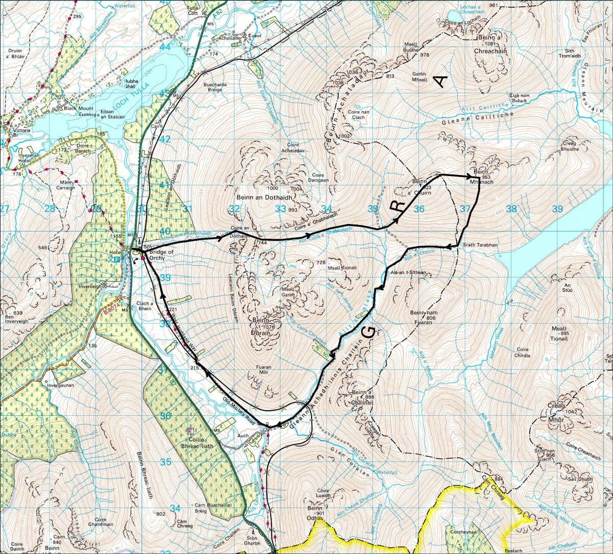
Start/Finish: Bridge of Orchy station (GR: NN300395)
Route: From Bridge of Orchy go through the underpass by the station, go through a gate and climb the eroded track to the high pass between Beinn Dorain and Beinn an Dothaidh. Descend grassy slopes down Coire a’ Ghabhalach to the track at the head of Auch Gleann. Follow the track N for a short distance then leave it to climb the SW slopes of Beinn a’Chuirn. From the summit head E, descend slightly, then climb to the summit of Beinn Mhanach. Descend S to the headwaters of the Allt Kinglass then follow the track by the river all the way to Auch. Cross the river and follow the West Highland Way NW for 5km to Bridge of Orchy.


Why are you making commenting on The Herald only available to subscribers?
It should have been a safe space for informed debate, somewhere for readers to discuss issues around the biggest stories of the day, but all too often the below the line comments on most websites have become bogged down by off-topic discussions and abuse.
heraldscotland.com is tackling this problem by allowing only subscribers to comment.
We are doing this to improve the experience for our loyal readers and we believe it will reduce the ability of trolls and troublemakers, who occasionally find their way onto our site, to abuse our journalists and readers. We also hope it will help the comments section fulfil its promise as a part of Scotland's conversation with itself.
We are lucky at The Herald. We are read by an informed, educated readership who can add their knowledge and insights to our stories.
That is invaluable.
We are making the subscriber-only change to support our valued readers, who tell us they don't want the site cluttered up with irrelevant comments, untruths and abuse.
In the past, the journalist’s job was to collect and distribute information to the audience. Technology means that readers can shape a discussion. We look forward to hearing from you on heraldscotland.com
Comments & Moderation
Readers’ comments: You are personally liable for the content of any comments you upload to this website, so please act responsibly. We do not pre-moderate or monitor readers’ comments appearing on our websites, but we do post-moderate in response to complaints we receive or otherwise when a potential problem comes to our attention. You can make a complaint by using the ‘report this post’ link . We may then apply our discretion under the user terms to amend or delete comments.
Post moderation is undertaken full-time 9am-6pm on weekdays, and on a part-time basis outwith those hours.
Read the rules here