
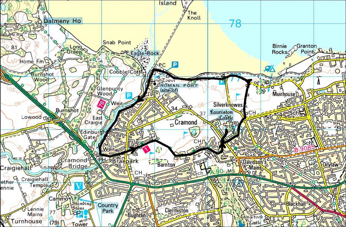
Location: Cramond and Lauriston, Edinburgh
Grade: Easy shore, river and town walk
Distance: 5 miles/8km
Time: 2-3 hours
This walk has a watery theme. There is a particular pleasure in walking beside water, and the start of this circuit underlines that, with an expansive view across the broad Firth of Forth towards Fife as you set off westwards.
The promenade is a very popular walk, and rightly so. In the foreground is Cramond Island, a trap for the unwary – the causeway leading to it rapidly disappears under water as the tide comes in. Before long you reach the village of Cramond, an attractive place with surprising evidence of Roman occupation in the remains of a fort, the nearby Eagle Stone and the discovery in 1997 of a lion statue, thought to be Roman, in the River Almond.
There are excellent coffee shops here too, should you feel like a break. A short diversion would take you to Cramond Kirk, which dates back to the 15th century.
The next part of the walk is on a delightful path by the river. This sparkling watercourse has its own conservation body, the Friends of the River Almond (FoRA), who have done much good work over the years. Before long you pass a small garden set up by the primary school, and then reach the remains of Fair-a-Far Mill, one of at least five mills that in the late 18th century used the river as a power source for iron making.
Upstream of here is a high weir over which the water slides like burnished silver. The path climbs on a long flight of steps and then drops to river level again before reaching Dowie’s Mill Lane. Shortly afterwards you leave the river, with the 17th century Cramond Old Brig just ahead.
Although the next section is semi-urban it is not without interest with a number of grand houses in varying architectural styles. A fenced path leads between two golf courses, Bruntsfield Links on the left and the Royal Burgess on the right.
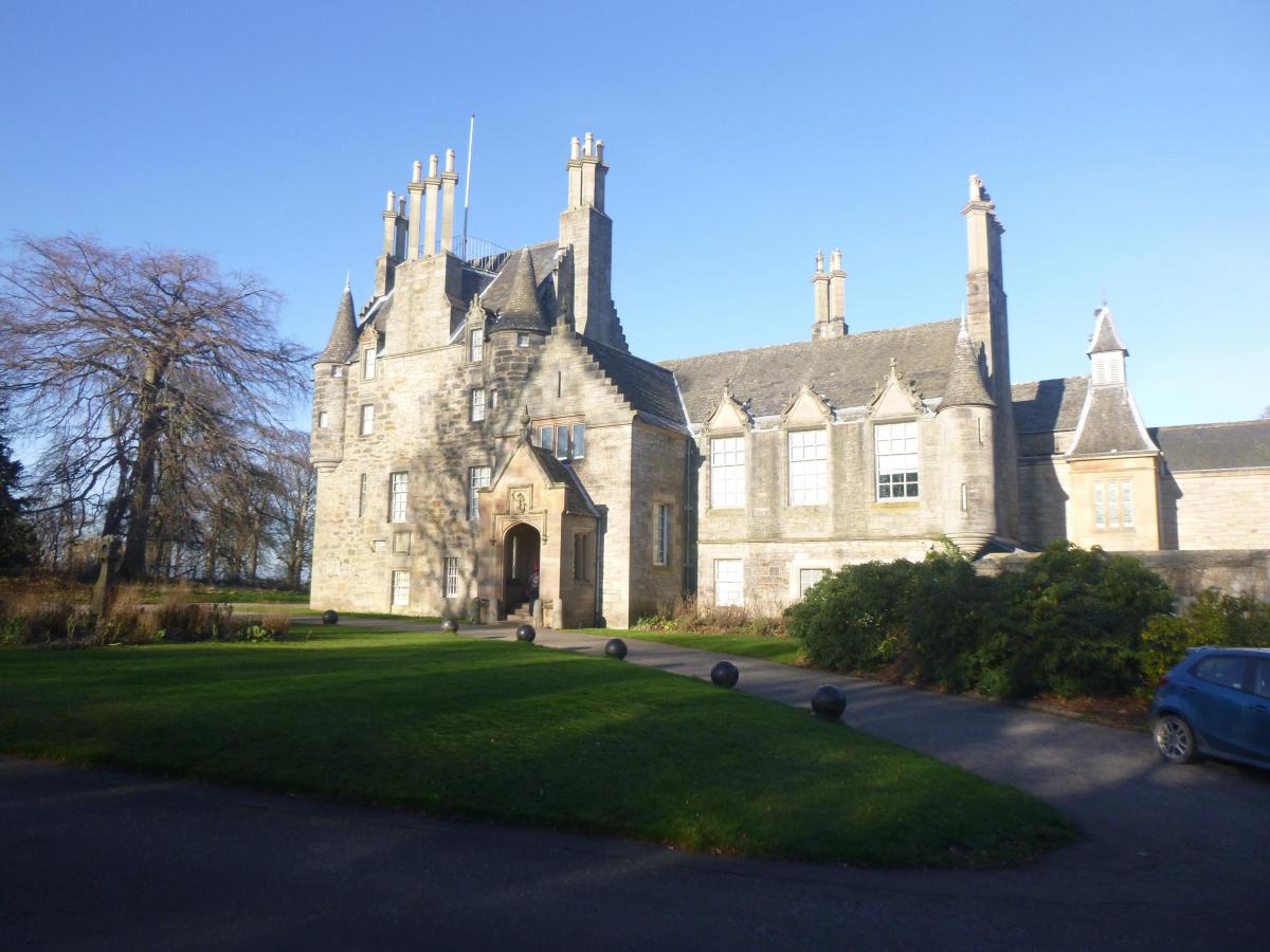
In time you cross Cramond Road South and enter the grounds of Lauriston Castle.
The original tower house here dates back to 1590. In the 1820s it was remodelled by William Burn, who added a large extension. In 1902 the castle was bought by the Reid family who carried out major renovations.
The family gifted the castle to the city of Edinburgh in 1926. It is now run by Edinburgh City Council and guided tours are available (weekends only in winter).
The extensive grounds, which include fine woodland and a
pond with a statue of a nymph, are free to explore at any time of
the year.
After leaving the Castle it is a short step back to Silverknowes, where a marked path takes you across the golf course and down towards the promenade again, with the same expansive view as you had at the beginning of the walk. It is a view that you could never tire of.
Roger Smith
ROUTE PLANNER
Map: OS 1:25,000 Explorer sheet 350 (Edinburgh).
Distance: 5 miles/8km
Time: 2-3 hours
Start/Finish: Silverknowes Esplanade car park (GR: NT202769)
Public transport: Regular buses from Edinburgh City Centre. Details from www.travelinescotland.com
Information: Edinburgh iCentre, 0131 473 3868 or https://edinburgh.org .
Route: Walk west along the Esplanade to its end. Turn L and follow signs for the River Almond Walkway. Follow the Walkway up to Dowie’s Mill Lane with the old Cramond Brig ahead. Turn L into Braepark Road. Cross Whitehouse Road into Barnton Avenue West. Continue on path between golf courses to reach Barnton Avenue East. In 800m, turn L into Barnton Park, cross Cramond Road South and enter the grounds of Lauriston Castle. Leave by the same exit, turn L and L again into Lauriston Farm Road. At roundabout cross Silverknowes Road, walk round golf clubhouse and follow path (white markers) down to Marine Drive. Turn L to return to car park.


Why are you making commenting on The Herald only available to subscribers?
It should have been a safe space for informed debate, somewhere for readers to discuss issues around the biggest stories of the day, but all too often the below the line comments on most websites have become bogged down by off-topic discussions and abuse.
heraldscotland.com is tackling this problem by allowing only subscribers to comment.
We are doing this to improve the experience for our loyal readers and we believe it will reduce the ability of trolls and troublemakers, who occasionally find their way onto our site, to abuse our journalists and readers. We also hope it will help the comments section fulfil its promise as a part of Scotland's conversation with itself.
We are lucky at The Herald. We are read by an informed, educated readership who can add their knowledge and insights to our stories.
That is invaluable.
We are making the subscriber-only change to support our valued readers, who tell us they don't want the site cluttered up with irrelevant comments, untruths and abuse.
In the past, the journalist’s job was to collect and distribute information to the audience. Technology means that readers can shape a discussion. We look forward to hearing from you on heraldscotland.com
Comments & Moderation
Readers’ comments: You are personally liable for the content of any comments you upload to this website, so please act responsibly. We do not pre-moderate or monitor readers’ comments appearing on our websites, but we do post-moderate in response to complaints we receive or otherwise when a potential problem comes to our attention. You can make a complaint by using the ‘report this post’ link . We may then apply our discretion under the user terms to amend or delete comments.
Post moderation is undertaken full-time 9am-6pm on weekdays, and on a part-time basis outwith those hours.
Read the rules here