
Location: An Caisteal and Beinn A'chroin
Stirlingshire
Grade: Serious mountain walk
Distance: 9 miles/14km
Time: 6-7 hours
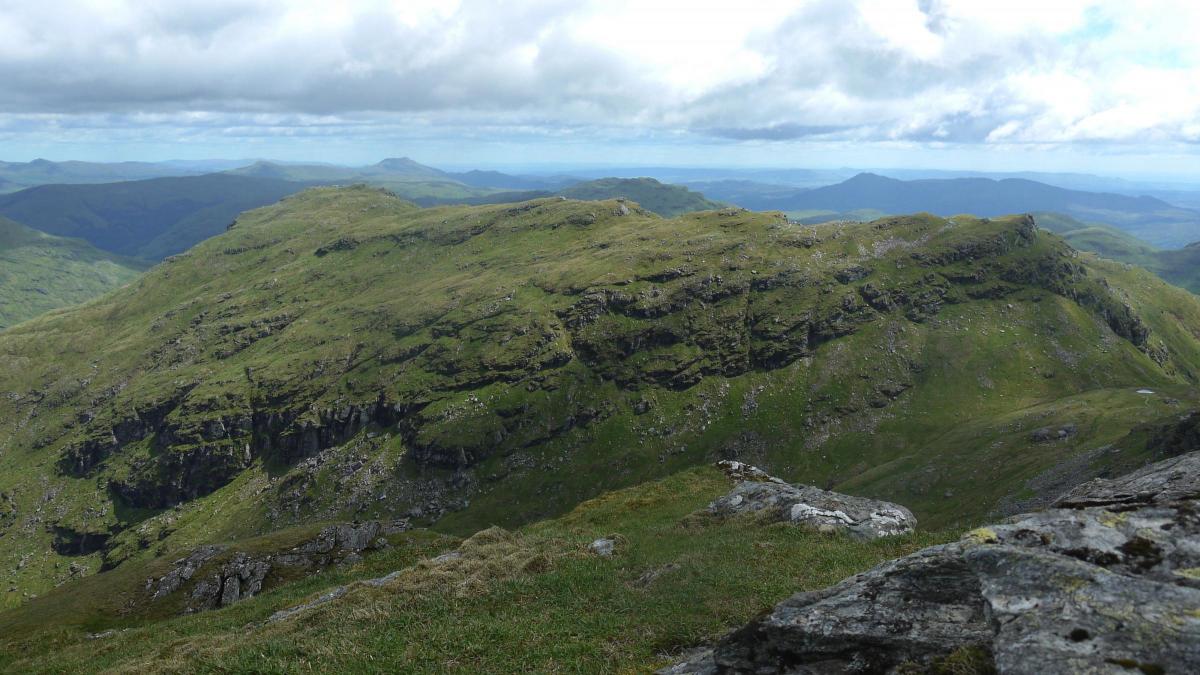
The Castle of Glen Falloch
LIKE their close neighbour Beinn Chabhair, these two craggy hills are made up of rocky outcrops above lower grassy slopes and their dual ascent offers a fine day's hill walking.
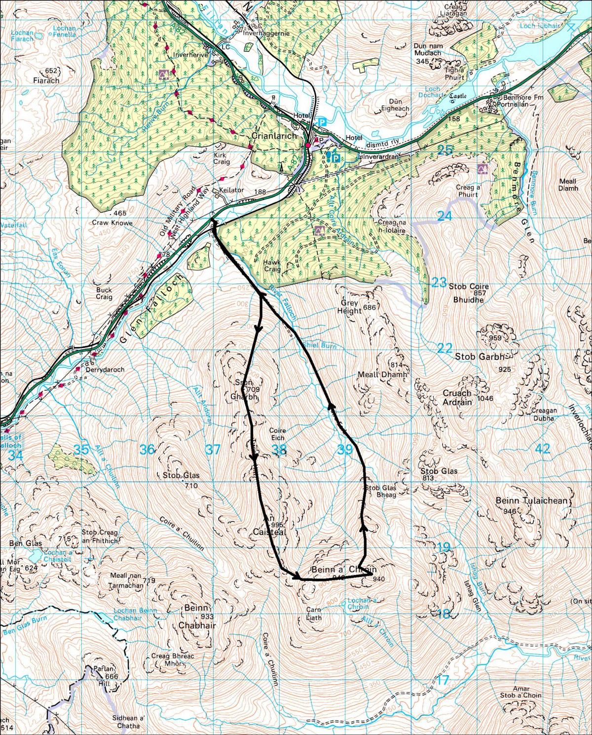
An Caisteal can be climbed directly from Glen Falloch from where the prominent tor which gives the hill its name is easily identified. The best approach is from a large layby on the A82 just south of Crianlarich. Cross a stile and go through an underpass below the railway. A bridge carries you over the River Falloch and a broad track, built recently to service a run-of-river hydro scheme, runs gently uphill. Follow this track for about a kilometre and after the second gate turn immediately right. This is where the hard work begins, following a muddy and in places indistinct footpath up the grassy flanks of Sron Gharbh to reach the ridge just below Twistin Hill.
There’s a fairly clear track up the ridge of Twistin Hill, with some rocky sections that may just require you to use your hands. Beyond this, the rocky tor known as the Castle, from where the hill gets its name, seems to bar further progress up this ridge but a path cuts its way across the top. If necessary, you can avoid the rather exposed route by passing the outcrop on its right. The rounded summit is a little distance further on from where the SSE ridge drops down grassy slopes and then through rocky ground to a level col, the Bealach Buidhe.
Above the col the path works its way south and then east and climbs steeply with some scrambling thrown in for good measure. It’s a good climb but suddenly you find yourself topping out on the first of several minor tops.
Beinn a'Chroin has two main tops separated by a 60 metre drop; its western top, the next one on the route, is the start of a short rocky ridge which leads to the eastern top. The OS gives the first top at 942m and the eastern top at 940m but this second top always seems a little higher to me. Take you choice, it does no harm to climb both.
From the 940m top, return along the outward path for a short distance and look out for a path running off to the right. This drops down onto the ridge leading to Stob Glas Bheag with a further descent down to Coire Earb where a faint path runs down by the nascent River Falloch eventually to meet the hydro track that will take you back to the railway underpass and your starting point.
Cameron McNeish
ROUTE PLANNER
Map: OS 1:50,000 Landranger sheet 50 (Glen Orchy & Loch Etive); Harveys 1:40,000 British Mountain Map, the Southern Highlands.
Distance: 9 miles/15km
Time: 5-6 hours
Start/Finish: Layby on A82 S of Crianlarich (GR: NN369239).
Public Transport: Regular bus and train services to Crianlarich, 3km from the start.
Details from www.travelinescotland.com
Information: Tyndrum TIC, 01838 400246 or www.walkhighlands.co.uk
Route: Follow rough track under the railway, cross the river by a bridge and follow the track up its W bank. After about 1km leave track at second gate and traverse E slopes of Sron Gharbh to reach the col between it and Twistin Hill. Follow a good path up and along Twistin Hill, descend then climb the steeper slopes of An Caisteal. Descend SSE ridge to col and climb rocky NW end of Beinn a'Chroin's summit ridge. Continue along crest to the two summits. From E summit backtrack a short distance to pick up another path running N. Follow it down the ridge of Stob Glas Bheag and continue descent into Coire Earb. Follow an indistinct path to meet the hydro track used earlier.


Why are you making commenting on The Herald only available to subscribers?
It should have been a safe space for informed debate, somewhere for readers to discuss issues around the biggest stories of the day, but all too often the below the line comments on most websites have become bogged down by off-topic discussions and abuse.
heraldscotland.com is tackling this problem by allowing only subscribers to comment.
We are doing this to improve the experience for our loyal readers and we believe it will reduce the ability of trolls and troublemakers, who occasionally find their way onto our site, to abuse our journalists and readers. We also hope it will help the comments section fulfil its promise as a part of Scotland's conversation with itself.
We are lucky at The Herald. We are read by an informed, educated readership who can add their knowledge and insights to our stories.
That is invaluable.
We are making the subscriber-only change to support our valued readers, who tell us they don't want the site cluttered up with irrelevant comments, untruths and abuse.
In the past, the journalist’s job was to collect and distribute information to the audience. Technology means that readers can shape a discussion. We look forward to hearing from you on heraldscotland.com
Comments & Moderation
Readers’ comments: You are personally liable for the content of any comments you upload to this website, so please act responsibly. We do not pre-moderate or monitor readers’ comments appearing on our websites, but we do post-moderate in response to complaints we receive or otherwise when a potential problem comes to our attention. You can make a complaint by using the ‘report this post’ link . We may then apply our discretion under the user terms to amend or delete comments.
Post moderation is undertaken full-time 9am-6pm on weekdays, and on a part-time basis outwith those hours.
Read the rules here