
Location: Cow Hill Trail, Lochaber
Grade: Fairly easy with some short hills
Distance: 6 miles/10km
Time: 3 hours
HOW often have you found yourself in Fort William, in the very shadow of some of our finest mountains, and have suffered frustration and disappointment because the hills are either swathed in cloud, or shrouded in curtains of rain?
It’s easy in such conditions to go for a swim in the pool, wander around the shops or gorge yourself in the Grog and Gruel, but far better to go for a shorter, less strenuous walk with good views and some fine woodland to enjoy. And at least you won’t be in danger of getting lost in the cloud.
Excellent paths, regular signposts and a fine circuit are the elements that make the Cow Hill Circuit an ideal stroll for frustrated mountaineers, family groups or ramblers. Add to that far-flung views down the length of Loch Linnhe to the hills of Morven or up Glen Nevis to Sgurr a’ Mhaim and the backside of the Ben. You won’t be disappointed.
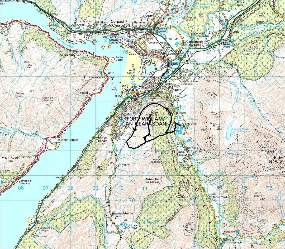
You can actually begin this route in the centre of Fort William but I prefer to start at the Braveheart Car Park in lower Glen Nevis. The car park gets its name from the film about the great Scots patriot William Wallace – some of the film was actually made in Glen Nevis.
From the car park turn right and follow the sign to Cow Hill Circuit. This route is so well signposted you don’t really need me to describe it for you, but I will anyway, just in case you miss a sign.
The path climbs gradually as it leaves the car parking area and begins its anti-clockwise circuit of Cow Hill itself, an area where local folk used to graze cattle. Indeed, the Forestry Commission have re-introduced cattle to this area – the way the beasts crop the grass helps wild flowers and butterflies! This section of the route is pretty up and down and there are several ‘link’ paths, particularly those that descend into Fort William. Keep to the main path and follow the signpost directions to Cow Hill Circuit and you’ll be fine.
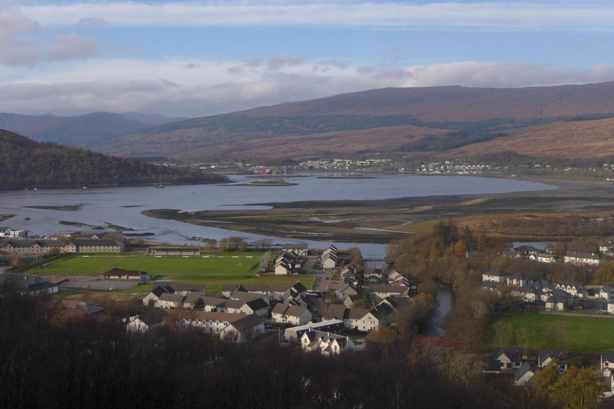
The route soon climbs above the town and shows it to be much more widespread and sprawling than the impression you get when you drive through. But note the hills across Loch Linnhe and the big hills behind including the highest in the UK and you begin to understand the town’s claims to be the Outdoors Capital of the UK.
Enjoy the views down the length of Loch Linnhe towards the hills of Morven. Unfortunately some power cables blight the views but hey, we all need electricity. The path actually follows the power lines so consider them to be an aid to navigation!
After about 3km you’ll come across a well-placed bench where the track turns abruptly left and begins to climb again, all the way to a signposted path junction. If you want to go to the summit of Cow Hill then turn left, climbing gradually to a rise where you will descend for a section and then climb again to the 287m summit, graced by a massive telecommunications mast. Curse it if you may, but most folk complain if they can’t get a mobile phone signal. This is the price we pay for such luxuries…
Retrace your steps to the signposted junction and turn left, down the Peat Track, a path once used by Glen Nevis residents to climb up here, cut peats, and carry them back to their homes once they had dried in the summer’s wind and sun. Once you get to the bottom of the track you’ll admire their tenacity, if not their endurance.
Take care as you enter the woodland because the path is steep in places and on the way down you’ll pass the boardwalk path that leads to Outlandia. This is essentially a tree-house that contains an artist’s studio, described as “a flexible meeting space in the forest for creative collaboration and research.” It’s apparently inspired by childhood dens, wildlife hides and bothies, by forest outlaws and Japanese poetry platforms, to foster links between creativity and the environment.
Enjoy the stillness of the woods as you zig-zag downhill through stands of spruce and larch and soon you’ll hit the main West Highland Way route on its final section to its terminus in Fort William. Avoid the WHW signposts but continue left back towards your starting point in the Braveheart Car Park.
Cameron McNeish
ROUTE PLANNER
Map: OS Landranger sheet 41 (Ben Nevis) or Explorer sheet 392 (Ben Nevis & Fort William)
Start/Finish: Braveheart Car Park, Glen Nevis (GR: NN122737)
Distance: 6 miles/10km
Time: 3 hours
Route: From the car park turn right and then almost immediately turn right again. Follow the obvious path uphill to an electricity pylon. The power line will keep you company for the next 3 km or so. Follow the path, ignoring link paths to the left and right. Pass a bench and continue straight ahead. Reach a junction with a small hilltop viewing point in from of you but ignore this, turn left and continue on the upper path still signposted Cow Hill Circuit. Follow the path all the way SSW, go through a gate and reach another bench. Leave the pylons behind now and turn left climbing to another path junction. Turn left and climb for 1.8km to the summit of Cow Hill. Return to the path junction and turn left. Go through another gate, keep to the right at a junction and descend steeply through the woods to the main West Highland Way path in Glen Nevis. Turn left onto the path and follow it back to the starting point.


Why are you making commenting on The Herald only available to subscribers?
It should have been a safe space for informed debate, somewhere for readers to discuss issues around the biggest stories of the day, but all too often the below the line comments on most websites have become bogged down by off-topic discussions and abuse.
heraldscotland.com is tackling this problem by allowing only subscribers to comment.
We are doing this to improve the experience for our loyal readers and we believe it will reduce the ability of trolls and troublemakers, who occasionally find their way onto our site, to abuse our journalists and readers. We also hope it will help the comments section fulfil its promise as a part of Scotland's conversation with itself.
We are lucky at The Herald. We are read by an informed, educated readership who can add their knowledge and insights to our stories.
That is invaluable.
We are making the subscriber-only change to support our valued readers, who tell us they don't want the site cluttered up with irrelevant comments, untruths and abuse.
In the past, the journalist’s job was to collect and distribute information to the audience. Technology means that readers can shape a discussion. We look forward to hearing from you on heraldscotland.com
Comments & Moderation
Readers’ comments: You are personally liable for the content of any comments you upload to this website, so please act responsibly. We do not pre-moderate or monitor readers’ comments appearing on our websites, but we do post-moderate in response to complaints we receive or otherwise when a potential problem comes to our attention. You can make a complaint by using the ‘report this post’ link . We may then apply our discretion under the user terms to amend or delete comments.
Post moderation is undertaken full-time 9am-6pm on weekdays, and on a part-time basis outwith those hours.
Read the rules here