
Location: Gairich
Grade: Moderately serious mountain walk
Distance: 9 miles/14km
Time: 5-7 hours
IT’S ironic that within a couple of miles of one of Scotland’s finest mountain footpaths lies one of the worst. The good path runs up the steep, airy edge of Gleouraich’s south-west ridge above Loch Quoich near Glengarry, a superb stalkers’ path that has been well maintained by the estate. But close by, at the eastern end of Loch Quoich, just south of its dam, another path leads to the Druim na Geid Salaich, a long, rising ridge that in turn gives access to the Munro of Gairich.
The boggy, rutted, poorly drained and badly eroded nature of this path shouldn’t really surprise anyone for this is a land notorious for its high rainfall. The area around Loch Quoich, just west of Glen Garry, has the distinction of being one of the wettest places in Scotland.
The area enjoys a real wilderness feel, despite the presence of a single-track road that runs along the north shore of the loch between Glen Garry and Kinloch Hourn.
For all its wetness, the Loch Quoich area, and its Munros, remains a great favourite amongst hill bashers.
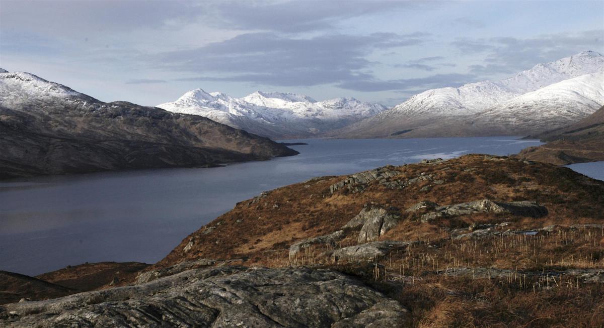
Gairich (3015ft/9l9m) stands in splendid isolation on the south side of the loch, gazing across the neck of water towards the Glengarry twins of Gleouraich and Spidean Mialach. A little way along the road north of the loch lies another magnificent Munro, Sgurr a’ Mhaoraich.
I’ve often driven along this road and thought that the finest way to climb Gairich would be to canoe across the loch and climb the hill by its broad north ridge. You could then canoe back across the loch and add Sgurr a’ Mhaoraich to your day’s tally.
This time, given the shorter hours of daylight, I was content with one Munro. After weeks of rain and wind, the Celtic winter god Biera got her act together, flourished her icicle wand and enveloped much of the Highlands in a smattering of snow and icy temperatures. This would be a good time to tackle Gairich, and I was hopeful her horrendously boggy approaches would form a deep-frozen highway.
A pale sun shone from a milky, creamy sky as I set out but despite the low temperatures underfoot conditions were not ideal – as the rainwater that had previously flooded the path had turned to ice. I might have been better with ice skates so I left the slippery path after a kilometre or so, and took a more direct route, over crisp, crunchy frozen turf, onto the Druim na Geid Salaich.
Once I reached the crest of the ridge overhead conditions dramatically improved too. Great streaks of blue sky appeared through the high cloud and the sun broke through – the first I’d seen in weeks. Away ahead of me I could see other climbers on the sharply defined east ridge of Gairich and beyond lay the jumbled hills of Knoydart.
As the ridge widens out onto the Bac nam Foid it usually becomes increasingly boggy and cut up by peat hags, but a couple of inches of fresh snow lay on top of old névé, hard snow that has frozen and thawed several times, and it was delight to walk on it. Soon I was climbing up through rocky outcrops and crags, avoiding the icy sections as much as possible.
Various tracks cross the south-east slopes of this hill and it’s easy to follow them too far west, but by keeping on a rising traverse as close to the crest as possible I managed to pick a line through the difficulties to the surprisingly broad summit ridge and cairn.
The cold was intense but the views were magnificent, the white crests of the hills rising from russet flanks. I could see the Cuillin of Skye, I could see Ben Nevis crouching over its acolytes but best of all were the Knoydart hills, wild Scotland in all her winter glory.
Cameron McNeish
ROUTE PLANNER
Map: OS 1:50,000 Landranger sheet 33 (Loch Alsh, Glen Shiel & Loch Hourn)
Distance: 9 miles/l4km
Approx Time: 5-7 hours
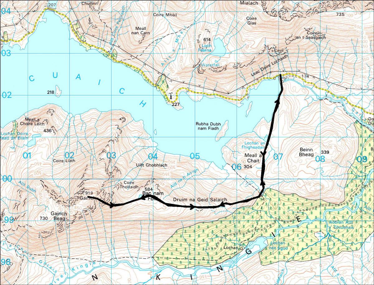
Start/Finish: Loch Quoich dam (GR: NN070024).
Route: From S end of dam a path leads to an old stalkers’ path that runs S over boggy moors to the edge of a forestry plantation. Here, another path runs due W up the Druim na Geid Salaich. Once the broad ridge crest is reached the path peters out but the going is easy and the broad ridge should be followed W to the final steep pull to Gairich. At the foot of this final rise a path reappears, but after a while it runs out on to the S face. Don’t be tempted by it but continue climbing on the ridge crest to the spacious summit and large cairn. Return the same way.
Due to current restrictions, we are running our favourite previously published walks. Please follow the Scottish Government’s latest coronavirus restrictions, see https://www.gov. scot/coronaviruscovid-19


Why are you making commenting on The Herald only available to subscribers?
It should have been a safe space for informed debate, somewhere for readers to discuss issues around the biggest stories of the day, but all too often the below the line comments on most websites have become bogged down by off-topic discussions and abuse.
heraldscotland.com is tackling this problem by allowing only subscribers to comment.
We are doing this to improve the experience for our loyal readers and we believe it will reduce the ability of trolls and troublemakers, who occasionally find their way onto our site, to abuse our journalists and readers. We also hope it will help the comments section fulfil its promise as a part of Scotland's conversation with itself.
We are lucky at The Herald. We are read by an informed, educated readership who can add their knowledge and insights to our stories.
That is invaluable.
We are making the subscriber-only change to support our valued readers, who tell us they don't want the site cluttered up with irrelevant comments, untruths and abuse.
In the past, the journalist’s job was to collect and distribute information to the audience. Technology means that readers can shape a discussion. We look forward to hearing from you on heraldscotland.com
Comments & Moderation
Readers’ comments: You are personally liable for the content of any comments you upload to this website, so please act responsibly. We do not pre-moderate or monitor readers’ comments appearing on our websites, but we do post-moderate in response to complaints we receive or otherwise when a potential problem comes to our attention. You can make a complaint by using the ‘report this post’ link . We may then apply our discretion under the user terms to amend or delete comments.
Post moderation is undertaken full-time 9am-6pm on weekdays, and on a part-time basis outwith those hours.
Read the rules here