

FIDDLER’S GILL
Location: Lanarkshire
Grade: Moderate countryside walk
Distance: 5.5 miles/9km
Time: 3-4 hours
This walk takes in an attractive section of the Clyde Walkway and then climbs to the village of Braidwood before returning above a beautiful – and unexpected – wooded gorge. It is typical of many walks in lowland Scotland in that it takes a bit of seeking out but once you have found it, the rewards are plentiful. It is a good walk for a short day, and the climb up towards Braidwood will have you glowing with warmth.
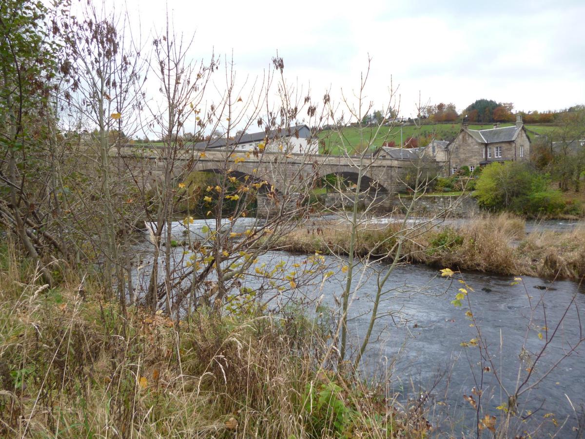
The first part of the walk follows the Clyde Walkway from the village of Crossford – its name clearly indicating that there has been a crossing point on the river here for centuries. Today there is a fine bridge arching across the river, which can be quite turbulent at this point.
The path is easy to follow and at one point climbs higher above the river. The next turn-off needs a little care. After the higher section of path, look up to the right to see a small group of houses. At the end of a large field you need to turn right towards these houses (at the point where you leave the walkway there is a footbridge straight ahead).
The path leads up to a minor road and then you start climbing, quite steeply for a while. The next section runs along the slope, and you may catch a glimpse of the unmistakeable pyramid of Tinto, Lanarkshire’s highest hill, before turning up into Braidwood, where the beautiful pond makes an ideal lunch stop if you have timed it right. Ducks and perhaps swans might come close in the hope of a titbit or two.
After this the walk takes a path above the dramatic little Fiddler’s Gill, one of many such small ravines in the valleys of the Clyde and its main tributaries. As with most of them, this one is heavily wooded with some superb mature trees. The Clyde Valley Woodlands National Nature Reserve includes half a dozen of these lovely spots.
The path wriggles down to cross a field, a slightly awkward bit, before crossing the Fiddler’s Burn and then using an old road to get back towards the start. Looking up to the left as you join the old road you may see the large mansionhouse called Lee Castle.
The final section leads down past Birkhill Farm and back across the Clyde, and I hope you will agree that it is a pleasant and occasionally surprising wee walk.
Roger Smith
ROUTE PLANNER
Map: OS Landranger sheet 72 (Upper Clyde Valley)
Distance: 5.5m/9km
Approx Time:: 3-4 hours
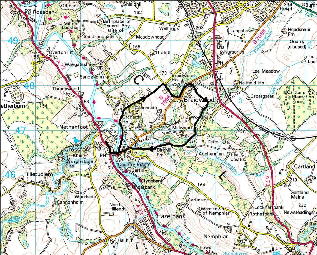
Start/Finish: Car park at rear of village hall, Crossford (GR: NS827465)
Route: TL on main road. In 500m TL over R.Clyde. TL on Clyde Walkway. In about 1.5km TR on path heading up to houses, Follow road uphill. At fork keep L, steeply uphill. At T-junction TR. At next junction keep L up to Braidwood. At pond TR on Loch Avenue past primary school. Keep ahead on path between hedges. At junction TR with Fiddler’s Gill to L. At road end go R through two gates. Walk by fence. Cross stile into field and walk diagonally down to gate. TL on road. Go R of metal gate on path down to cross burn by footbridge. Climb to meet old road and TR. Continue with road past Birkhill Farm. At T-junction TR and then L on road to cross Clyde and go R back to car park.
Buy OS maps and guidebooks from all good bookshops, and online at os.uk/adventure
Due to current restrictions, we are running our favourite previously published walks. As lockdown eases, please follow the Scottish Government’s coronavirus restrictions, see www.gov.scot/coronavirus-covid-19


Why are you making commenting on The Herald only available to subscribers?
It should have been a safe space for informed debate, somewhere for readers to discuss issues around the biggest stories of the day, but all too often the below the line comments on most websites have become bogged down by off-topic discussions and abuse.
heraldscotland.com is tackling this problem by allowing only subscribers to comment.
We are doing this to improve the experience for our loyal readers and we believe it will reduce the ability of trolls and troublemakers, who occasionally find their way onto our site, to abuse our journalists and readers. We also hope it will help the comments section fulfil its promise as a part of Scotland's conversation with itself.
We are lucky at The Herald. We are read by an informed, educated readership who can add their knowledge and insights to our stories.
That is invaluable.
We are making the subscriber-only change to support our valued readers, who tell us they don't want the site cluttered up with irrelevant comments, untruths and abuse.
In the past, the journalist’s job was to collect and distribute information to the audience. Technology means that readers can shape a discussion. We look forward to hearing from you on heraldscotland.com
Comments & Moderation
Readers’ comments: You are personally liable for the content of any comments you upload to this website, so please act responsibly. We do not pre-moderate or monitor readers’ comments appearing on our websites, but we do post-moderate in response to complaints we receive or otherwise when a potential problem comes to our attention. You can make a complaint by using the ‘report this post’ link . We may then apply our discretion under the user terms to amend or delete comments.
Post moderation is undertaken full-time 9am-6pm on weekdays, and on a part-time basis outwith those hours.
Read the rules here