

Location: Argyll
Grade: Moderate hill walk
Distance: 6 miles/10km
Time: 5-6 hours
HIDDEN away in a cleft of wild mountainous land between Glen Coe and Glen Etive, the Corbett of Beinn Maol Chaluim, 2957ft/907m, does not attract large numbers of hillwalkers.
Its proximity to the popular Munros of Glen Coe tends to keep it relatively free of people. Those hillwalkers who do take the long single-track road down Glen Etive are usually intent on bagging the impressive Ben Starav.
With every car park along the A82 through Glen Coe full to overflowing I decided I wanted a quiet day on the hill. I knew from past experience on Beinn Maol Chaluim that I needn’t go far in search of it.
Glen Etive, unusually, was also busy but with paddlers not hillwalkers. Every little waterfall had half a dozen stubby, brightly coloured canoes waiting to take the plunge and the grass verges were full of cars and people camping for the Easter weekend. Despite the general air of busyness I was still confident of a quiet day on Beinn Maol Chaluim.
A large herd of red deer grazed close to the road as I parked the car just past Inbhir-fhaolain opposite the wind-ruffled waters of Lochan Urr. I momentarily thought of dropping down from the road to the lochside to take a photograph of the twin Buachailles of Glen Etive with the loch as a foreground but being an extremely lazy photographer decided, conveniently, that the light was too flat.
And it was. Dark clouds just tickled the summits of the highest peaks and it felt unseasonably cold. There was a greyness in the day that suggested that winter hadn’t quite yet finished with us.
Despite the chill it didn’t take long to get sweating on the lower slopes of Creag na Caillich, en route to Beinn Maol Chaluim’s southern ridge.
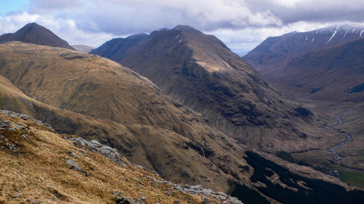
The slope is unrelentingly steep but the upside is that you can gain height quickly and within 20 minutes or so I was getting a hint of what the views were to be like later in the day. The twin Buachailles looked magnificent and behind me the steep slopes of Stob Dubh fell into the glen in one scree-scarred curtain. Further down the glen I caught the silver sparkle of Loch Etive, trapped in the cleft between triple-topped Ben Starav and Beinn Trilleachean. Once you reach the broad south ridge of Beinn Maol Chaluim only a steep, short and sharp climb separates you from the magnificent high level ridge that leads to the summit. Although steep, it’s straightforward enough until you reach the top of it.
There, the summit ridge is protected by a long wall of vertical red porphyry. You can avoid these crags by traversing right for some distance but there are one or two breaches in the wall where even non-scramblers can clamber through.
Beyond it some minor tops lead to the summit ridge itself, which is pleasantly narrow and today, was fringed with snow.
What a marvellous high-level romp this produces – on one side steep slopes lead to another ridge that connects with the Munro of Sgorr na h-Ulaidh and on the other side even steeper slopes drop down into the bare fastness of Gleann Fhaolain, the narrow glen that separates Beinn Maol Chaluim from the Bidean nam Bian massif.
I had harboured tentative thoughts about descending into Gleann Fhaolain, climbing steeply to Bidean, following its ridge east to Stob Coire Sgreamhach before descending back into Glen Etive, but dark clouds obscured Bidean and there appeared to be a dusting of new snow on the higher tops. Discretion being the better part of valour (I didn’t carry an ice axe) I loitered for a while beside the two summit cairns, dropped down out of the wind for a scenic lunch break, then returned to Glen Etive the way I had come.
As a reward the sun shone for a while on the descent, illuminating some of the finest views you’ll see in this magnificently mountainous part of highland Scotland. And was the hill as quiet as I expected? No, not quite. I saw three other people. Not bad for Easter weekend.
CAMERON MCNEISH
ROUTE PLANNER
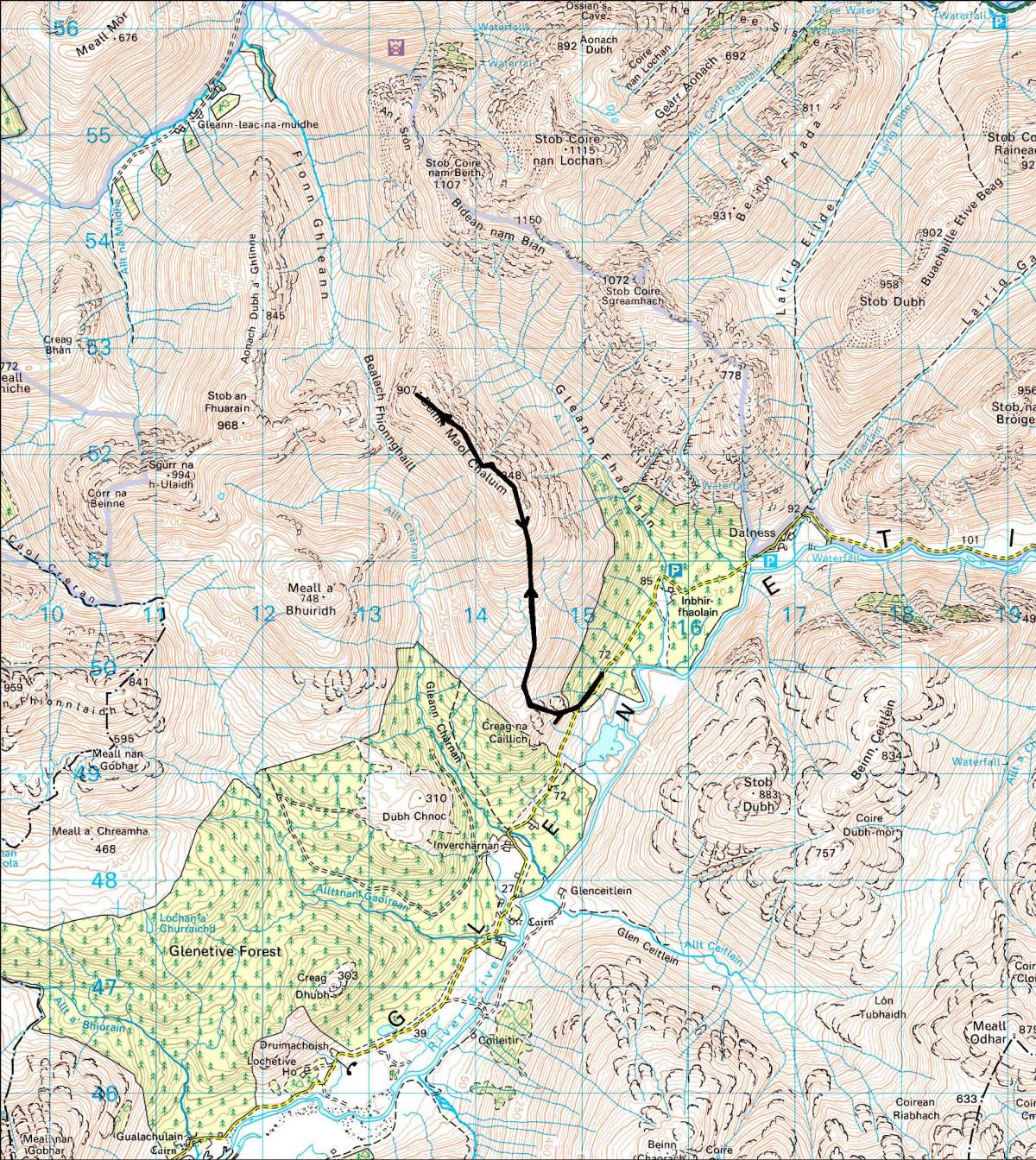
Map: OS Landranger sheets 41 (Ben Nevis) and 50 (Glen Orchy & Loch Etive)
Distance: About 6 miles/10km
Time: 5-6 hours
Start/Finish: Glen Etive road (GR: NN149496)
Route: Leave the road and climb steep and grassy slopes W of the forest plantation. Pass some rocky outcrops on the left to reach the S ridge of Beinn Moal Chaluim. Continue N on the ridge and climb steeply to where some steep crags appear to bar further progress. Scramble over the crags or avoid them by traversing to the right. Cross a couple of subsidiary tops before you reach the long summit ridge. Follow this to the summit, which lies at the N end of the ridge. Return the same way.
Due to restrictions, we are running our favourite previously ublished walks. Please see www.gov.scot for current travel rules


Why are you making commenting on The Herald only available to subscribers?
It should have been a safe space for informed debate, somewhere for readers to discuss issues around the biggest stories of the day, but all too often the below the line comments on most websites have become bogged down by off-topic discussions and abuse.
heraldscotland.com is tackling this problem by allowing only subscribers to comment.
We are doing this to improve the experience for our loyal readers and we believe it will reduce the ability of trolls and troublemakers, who occasionally find their way onto our site, to abuse our journalists and readers. We also hope it will help the comments section fulfil its promise as a part of Scotland's conversation with itself.
We are lucky at The Herald. We are read by an informed, educated readership who can add their knowledge and insights to our stories.
That is invaluable.
We are making the subscriber-only change to support our valued readers, who tell us they don't want the site cluttered up with irrelevant comments, untruths and abuse.
In the past, the journalist’s job was to collect and distribute information to the audience. Technology means that readers can shape a discussion. We look forward to hearing from you on heraldscotland.com
Comments & Moderation
Readers’ comments: You are personally liable for the content of any comments you upload to this website, so please act responsibly. We do not pre-moderate or monitor readers’ comments appearing on our websites, but we do post-moderate in response to complaints we receive or otherwise when a potential problem comes to our attention. You can make a complaint by using the ‘report this post’ link . We may then apply our discretion under the user terms to amend or delete comments.
Post moderation is undertaken full-time 9am-6pm on weekdays, and on a part-time basis outwith those hours.
Read the rules here