


Location: Assynt
Grade: Serious mountain walk
Distance: 10 miles/16km
Time: 6-7 hours
It was the ancient Norse who gave Ullapool its name. Ulli’s Steading was then, as it is now, a gentle oasis amid a harsh, mountainous landscape, but drive north from the town, over the spine of the Rhue peninsula, and you enter another world.
Ardmair is a magnificent spot. From the camp-site a spit of white shingle curves gracefully out into the bay pointing towards the sanctuary of Isle Martin. Beyond, protecting the bay from the Minch gales, the Summer Isles float alluringly on their sea of green. Flocks of dunlin and ringed plover feed on the salt flats, gulls wheel overhead and brightly coloured fishing boats bob and dip on the water, but for all these attractions of sea and shore it is a mountain which dominates the scene.
An extensive wall of weathered Torridonian sandstone commands the northern shore of the bay, a relic of one of the most ancient land masses in the world. The long sandstone barrier runs from Garbh Choireachain to Speicin Coinnich, and is collectively known as Ben Mor Coigach. The hill’s protective cap of Cambrian quartzite has long since gone, but the bare bones of this venerable relic still rise straight from the sea to nearly 750 metres, a long wall of seamed buttresses, gullies and cliffs.
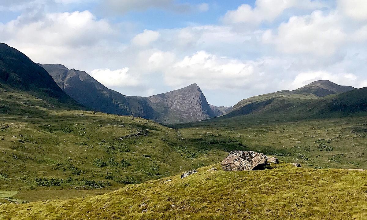
While that seaward wall is impressive, it’s really only a front, hiding an intricate, complex system of peaks, ridges, corries and lochans. This area of Coigach is a gem. Unspoiled and challenging, it begins to reveal itself more fully as you drive further north. Ben Mor Coigach, at 743m, is the highest summit, but the other main peak of the area, Sgurr an Fhidhleir, rises to a sharp and dramatic point. It’s a high eyrie of a summit, the culmination of a huge blade of rock that rises from the bare moorland close to the reflective waters of Lochan Tuath.
The traverse of these two hills brings together all the best characteristics of a walk which blends sea and mountain in that distinctive combination that you only find on Scotland’s western seaboard. There’s a peculiar quality to the blend here in Coigach, as though the spaciousness of the vast seascape emphasises the height of the hill, and you catch a notion you’re mounting a staircase to the heavens.
Indeed, it’s perhaps not too fanciful to imagine the traverse of Ben Mor Coigach’s long south-west ridge beyond Ardmair Bay as a high-level promenade to Tir nan Og, the fabled Land of the Blest beyond the shimmering ocean of the Celtic twilight.
At Drumrunie junction on the A835 a minor road runs west towards Achiltibuie. As everyone else heads off to climb Stac Pollaidh, or fester on the pale yellow sands of Achnahaird Bay, park your vehicle and cross the river just east of Loch Lurgainn. A faint path, rising steadily on the right bank of the Allt Claonaidh, will take you as far as Lochan Tuath, which mirrors the mighty north-west prow of Sgurr an Fhidhleir, the peak of the fiddler. Walkers don’t follow the prow: that’s the domain of rock climbers who’ll find a long and exposed climb of Very Severe standard.
South of the prow, a prominent heather-filled gully climbs steeply up to the bealach between The Fiddler and Ben Mor Coigach and from there easy slopes lead to the summit of Sgurr an Fhidhleir, a stunning place with magnificent views over the Inverpolly peaks – Cul Mor, Cul Beag and the improbable outline of Stac Pollaidh. This hill has been described as a ‘mountain straight out of a fairy tale’, with a ragged and spiky crest looking for all the world like some primeval stegosaurus.
Retrace your steps to the broad bealach and climb the easy, grassy slopes to Ben Mor Coigach. The long south-west ridge towards Garbh Choireachan is the highlight of this glorious walk. Enjoy the succession of rocky towers and sandy paths which make this ridge such a delight and take time to enjoy the views out over the Summer Isles and on a good day, across the Minch to Harris and Lewis. Given reasonably clear weather you’ll see the Cuillin of Skye, the Torridons, An Teallach, the Beinn Dearg hills and the magnificent spread of northern hills from Inverpollaidh to Assynt. Immediately below your feet lies Isle Martin, which was gifted to the locally based Isle Martin Trust by the RSPB in the spirit of ‘land reform and devolution’. This little nature reserve was the first land the RSPB has transferred to community ownership.
It’s well worth while scrambling out to the end of the ridge before making your way back to the summit of Ben Mor Coigach, and eventually over Beinn Tarsuinn and back to the start at the end of a glorious walk.
ROUTE PLANNER
Map: OS 1:50,000 Landranger sheet 15 (Loch Assynt).
Distance: 10 miles/16km.
Time: 6-7 hours.
Start/finish: Minor road to Achiltibuie, at GR: NC140068.
Information: Ullapool TIC, 01854 612486.
Route: Cross the river with care and follow the right bank of the Allt Clonaidh to Lochan Tuath. Climb a heathery gully to the bealach between The Fiddler and Ben Mor Coigach and walk up to the summit of Sgurr an Fhidleir. Walk back to the bealach and continue to Ben Mor Coigach. Follow the south-west ridge to Garbh Choireachan. Walk back again to Ben Mor Coigach and on to the small bealach below Speicin Coinnich, and then, on steepening slopes, down to the long ridge of Beinn Tarsuinn. Make your way along the ridge, continue over the summit and down steep, heathery slopes to the Allt Claonaidh and the boggy path back to the road.
Due to restrictions, we are running our favourite previously
published walks.
We are running our favourite previously published walks due to a backlog caused by Covid


Why are you making commenting on The Herald only available to subscribers?
It should have been a safe space for informed debate, somewhere for readers to discuss issues around the biggest stories of the day, but all too often the below the line comments on most websites have become bogged down by off-topic discussions and abuse.
heraldscotland.com is tackling this problem by allowing only subscribers to comment.
We are doing this to improve the experience for our loyal readers and we believe it will reduce the ability of trolls and troublemakers, who occasionally find their way onto our site, to abuse our journalists and readers. We also hope it will help the comments section fulfil its promise as a part of Scotland's conversation with itself.
We are lucky at The Herald. We are read by an informed, educated readership who can add their knowledge and insights to our stories.
That is invaluable.
We are making the subscriber-only change to support our valued readers, who tell us they don't want the site cluttered up with irrelevant comments, untruths and abuse.
In the past, the journalist’s job was to collect and distribute information to the audience. Technology means that readers can shape a discussion. We look forward to hearing from you on heraldscotland.com
Comments & Moderation
Readers’ comments: You are personally liable for the content of any comments you upload to this website, so please act responsibly. We do not pre-moderate or monitor readers’ comments appearing on our websites, but we do post-moderate in response to complaints we receive or otherwise when a potential problem comes to our attention. You can make a complaint by using the ‘report this post’ link . We may then apply our discretion under the user terms to amend or delete comments.
Post moderation is undertaken full-time 9am-6pm on weekdays, and on a part-time basis outwith those hours.
Read the rules here