
Location: Dumfries & Galloway
Grade: Moderate hillwalk
on rough terrain
Distance: 9 miles/15km
Time: 4-6 hours
Situated in the north of the Galloway Forest Park, Shalloch on Minnoch is the most westerly Corbett (Scottish hill between 2500-2999ft) in southern Scotland.
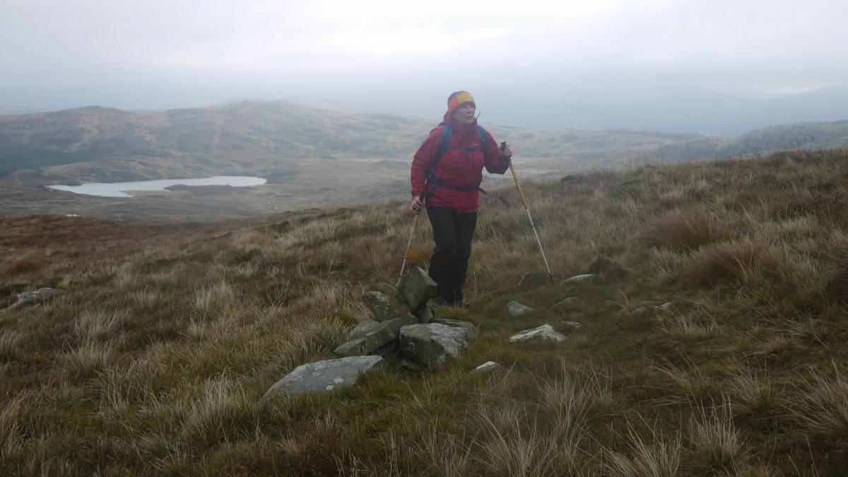
While its western flanks are swathed in forestry plantations, the upper slopes of the hill are clear and because of its westerly position, it offers some of the finest views in the area.
On a clear day the view from the summit of Shalloch on Minnoch takes in the Mournes of Ulster, the Lakeland Fells, the Isle of Man, the Mull of Kintyre and the islands of Arran, Jura and Ailsa Craig.
The name Shalloch on Minnoch could mean, ‘the heel of the Minnoch ridge’, assuming that Shalloch comes from the gaelic word sail or saileag.
The word could also come from the Gaelic word sealg, meaning a hunt, which ties it rather nicely with one of its neighbours, Mullwharcar, which means the hill of the huntsman’s horn. Minnoch probably comes from the Gaelic word for a rounded ridge-like hill, monadh.
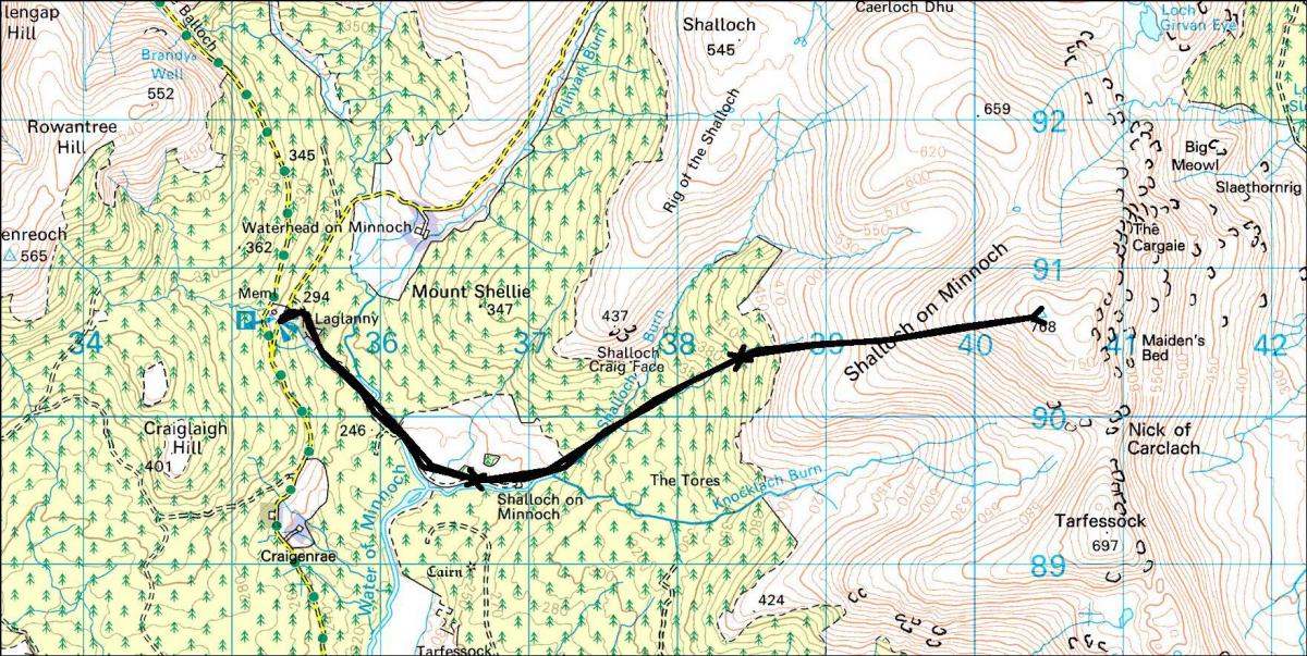
The car park at the beginning of the route commemorates David Bell, a local writer and cyclist and is situated close to Rowantree Junction where there was once an inn and a toll-house.
It was in this location that a tinker’s body was once found, giving the place the name of the ‘Murder Hole’. In his novel about droving in the Galloway area, The Raiders, author S.R.Crockett nicked the location and moved it close to Loch Neldricken, north of Glen Trool.
A sign beside the road indicates ‘Shalloch on Minnoch’ but that’s the last signpost you’ll see. Follow the forest road past the house at Laglanny and continue to where the track crosses the Water of Minnoch.
Turn right here and follow the trail to a disused farm, also called Shalloch on Minnoch. The easy walking stops here and it’s muddy paths for the rest of the route through the forest.
Follow the river for about 400m to where a girder bridge-of-sorts takes you over to the east bank. Follow the burn now for about 800m to where a tributary flows down through a firebreak. Follow the firebreak, at times crawling below the spreading branches of the pines, until you break free from the trees with an easy, if long, climb up the hill’s west ridge to the trig point summit.
Retrace your steps to descend, or alternatively, if you have the time, head south from Shalloch on Minnoch over Nick of Carlach, and then over Tarfessock. From here a long tarn-splattered ridge works its way south over Carmeddie Brae then up scree slopes to the summit of Kirriereoch Hill, which is about 150m south of an old wall.
To descend follow the wall down the west ridge and head for a noticeable fire-break in the forest which follows the line of the Pillow Burn.
Soon you’ll come across a forestry track which passes Kirrriereoch farm to join up with the public road about 4km south of the Bell car park.
Cameron McNeish
ROUTE PLANNER
Map: OS 1:50,000 Landranger sheet 77 (Dalmellington & New Galloway)
Distance: About 9 miles/15km
Time: 4-6 hours
Start/finish: Bell Memorial car park on the Straiton to Bargrennan road (GR: NX353907).
Public transport: None to the start.
Information: www.gallowayforestpark.com
Route: From the car park, take the forest road (marked Shalloch on Milloch) that runs past the house Laglanny. After 800m or so the road turns L over a bridge and once you’ve crossed turn R and follow the track to the ruined farm of Shalloch on Minnoch. Go through the farm, past a sheepfold, and follow the Shalloch Burn which is crossed on a girder bridge about 400m beyond the farm. Follow the stream for about 800m to where a firebreak follows a tributary burn. Follow the muddy, and at times awkward, footpath up the firebreak until clear of the trees. Now climb the tussocky grass slopes of Shalloch on Minnoch’s west ridge to the 768m summit. Return the same way.
We are running our favourite previously published walks due to a backlog caused by Covid


Why are you making commenting on The Herald only available to subscribers?
It should have been a safe space for informed debate, somewhere for readers to discuss issues around the biggest stories of the day, but all too often the below the line comments on most websites have become bogged down by off-topic discussions and abuse.
heraldscotland.com is tackling this problem by allowing only subscribers to comment.
We are doing this to improve the experience for our loyal readers and we believe it will reduce the ability of trolls and troublemakers, who occasionally find their way onto our site, to abuse our journalists and readers. We also hope it will help the comments section fulfil its promise as a part of Scotland's conversation with itself.
We are lucky at The Herald. We are read by an informed, educated readership who can add their knowledge and insights to our stories.
That is invaluable.
We are making the subscriber-only change to support our valued readers, who tell us they don't want the site cluttered up with irrelevant comments, untruths and abuse.
In the past, the journalist’s job was to collect and distribute information to the audience. Technology means that readers can shape a discussion. We look forward to hearing from you on heraldscotland.com
Comments & Moderation
Readers’ comments: You are personally liable for the content of any comments you upload to this website, so please act responsibly. We do not pre-moderate or monitor readers’ comments appearing on our websites, but we do post-moderate in response to complaints we receive or otherwise when a potential problem comes to our attention. You can make a complaint by using the ‘report this post’ link . We may then apply our discretion under the user terms to amend or delete comments.
Post moderation is undertaken full-time 9am-6pm on weekdays, and on a part-time basis outwith those hours.
Read the rules here