
Location: Rothiemurchus
and the Lairig Ghru, Highland
Grade: Moderate lower level walk
Distance: 10 miles/16km
Time: 5-6 hours
We are past the winter solstice, thank goodness. I’ve always marked the winter solstice in my diary. It heralds, of course, the shortest day of the year, a turning point, a demarcation line which signals a steady lengthening of the days and all the natural response that brings with it.
It’s small wonder our pagan ancestors celebrated this event with such gusto and no coincidence that our Christian fathers chose this midwinter date to celebrate the birth of Christ.
According to many historians, Jesus was more likely to have been born in March. A compelling date in itself as a time of renewal, fresh start and a new birth in the natural world, but the opportunity to break up the dour winter months, and replace the pagan winter solstice festival, was obviously too much of a temptation.
I for one am delighted that we were able to celebrate Christmas a few weeks back, coming in the middle of the darkest period of the year, bringing with it a ray of light and cheer.
Last year I marked the winter solstice with some satisfaction. It was a grey and sullen day when darkness crept across the sky in the early afternoon as though winter was stamping its mid-term authority on the land; but the very next afternoon the lengthening of the day, although imperceptible in terms of time, was apparent in terms of weather, a sign of hope like the brightest of rainbows after a storm.
The great trough of the Lairig Ghru, the gloomy pass, cuts through the bulky massif of the Cairngorms, a cleft caused by glaciation with the swelling upthrusts of Beinn Macdui on one side and Braeriach on the other – Britain’s second and third highest hills respectively.
The through walk from Coylumbridge near Aviemore to Braemar is nearly 30 miles in length and rises to a height of over 2,500 feet, a bit long for a winter’s day so instead I wandered through the ancient forest of Rothiemurchus to a high point from where you can virtually gaze into the jaws of the Lairig itself.
Rothiemurchus is the name of the parish that lies between the River Spey and the summits of the high Cairngorms.
Because of the rich variety of the landforms contained in the estate the landscape passes from low-lying agricultural fields, through open heather moorland to the magnificent remnants of the ancient Forest of Caledonia. The route of the Lairig Ghru was used in times gone by as a drove road, one of the highest in the country, and today is one of the classic high-level passes in Scotland.
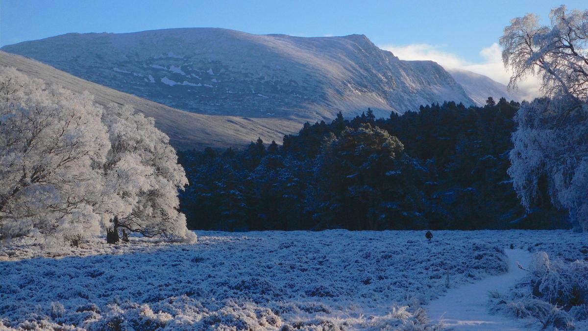
I left Coylumbridge in dazzling sunshine made even more spectacular by a heavy hoar frost that had turned the trees white. I followed the path to the old Cairngorm Club footbridge over the Allt Druidh. The path crosses a large clearing in the pine woods with the V-shape of the Lairig away ahead, and continues beyond the river to a path junction known locally as Piccadilly!
From here my route lay upwards, climbing steadily past ancient pines, gnarled with time, trees which gradually become smaller and more stunted the higher you climb. Soon you’ll leave the pines behind you and reach another path leading off to the left. This is the high point of the route and from here you can enjoy the views into the jaws of the Lairig Ghru and behind you over Rothiemurchus towards the blue swell of the Monadhliath mountains. The path leads to the Joint Services Training Centre at Rothiemurchus Lodge, then follows a land rover track back down towards Glenmore.
After a mile or so I desperately wanted to swop the commercial forest that had sprung up on either side of me for the natural beauty of the pine woods so I took another track that runs off to the left and followed its winding course through the woods again to Piccadilly and the path back to Coylumbridge and home.
Cameron McNeish
ROUTE PLANNER
Map: OS 1:50,OOO Landranger sheet 36 (Grantown & Aviemore), Harveys Mountain Map, The Cairngorms
Distance: About 10 miles/16km
Time: 5-6 hours
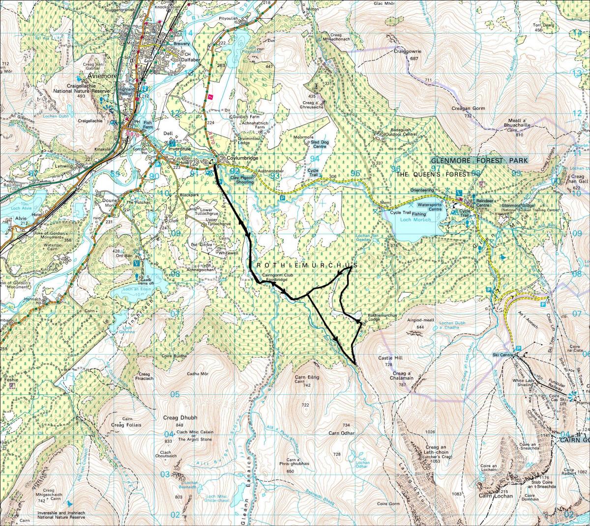
Start/Finish: Coylumbridge, on the B970 Aviemore to Glenmore road (GR: NH917108)
Information: Aviemore TIC, 01479 810930
Route: Leave Coylumbridge and follow signposted path that runs alongside the campground. At fork, go L past a large cairn, cross the clearing with dense juniper bushes on R before crossing a stream and heading back into woodland. Further on go into a fairly dense conifer plantation. Cross Allt Druidh by the Iron Bridge, follow the path through another clearing and soon you’ll reach a point where paths go off in various directions. Take the path climbing S, past the signpost which points to the Lairig Ghru and Braemar. Soon leave the pines behind and reach another path leading off L. A signpost points to Rothiemurchus Lodge. Follow the path past the Lodge and follow a track back down towards Glenmore. After about 1.5km a footpath leaves this track to the left and winds through the forest to meet up with your outward route. Follow the path back to Coylumbridge.
We are running our favourite previously published walks
see www.gov.scot for current travel rules


Why are you making commenting on The Herald only available to subscribers?
It should have been a safe space for informed debate, somewhere for readers to discuss issues around the biggest stories of the day, but all too often the below the line comments on most websites have become bogged down by off-topic discussions and abuse.
heraldscotland.com is tackling this problem by allowing only subscribers to comment.
We are doing this to improve the experience for our loyal readers and we believe it will reduce the ability of trolls and troublemakers, who occasionally find their way onto our site, to abuse our journalists and readers. We also hope it will help the comments section fulfil its promise as a part of Scotland's conversation with itself.
We are lucky at The Herald. We are read by an informed, educated readership who can add their knowledge and insights to our stories.
That is invaluable.
We are making the subscriber-only change to support our valued readers, who tell us they don't want the site cluttered up with irrelevant comments, untruths and abuse.
In the past, the journalist’s job was to collect and distribute information to the audience. Technology means that readers can shape a discussion. We look forward to hearing from you on heraldscotland.com
Comments & Moderation
Readers’ comments: You are personally liable for the content of any comments you upload to this website, so please act responsibly. We do not pre-moderate or monitor readers’ comments appearing on our websites, but we do post-moderate in response to complaints we receive or otherwise when a potential problem comes to our attention. You can make a complaint by using the ‘report this post’ link . We may then apply our discretion under the user terms to amend or delete comments.
Post moderation is undertaken full-time 9am-6pm on weekdays, and on a part-time basis outwith those hours.
Read the rules here