

Drivers have been warned to take care as a band of wintery weather descends across Scotland and much of the UK.
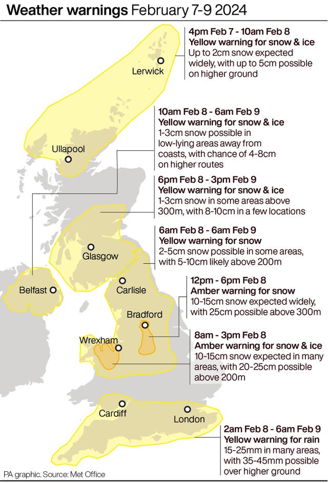
Yellow weather alerts for snow and ice have been issued, with up to 10cm forecast to fall in some areas north of the border.
The alert covers Glasgow, Southern Scotland and the central belt from 6pm tonight to 3pm on Friday, and follows an earlier alert.
The Met Office said up snowfall could vary, with 1-3cm expected widely across the country.
Schools and nurseries in Orkney and Shetland have been shut this week due to heavy snow.
The worst of the latest bad weather is expected to hit England and Wales, where up to 25cm of snow is forecast.
READ MORE: Band of heavy snow headed to the UK later this week
Amber weather warnings for snow have been issued for parts of northern England and north Wales, while a mixture of yellow rain and snow warnings will be in force across the four nations.
The amber warning across the Peak District and south Pennines is in place from noon until 6pm on Thursday, with up to 25cm of snow forecast across high ground above 300 metres.
 (PA Graphics)
The Met Office said strong and gusty easterly winds may lead to “some drifting in places”, and that 10-15cm of snow is expected quite widely across the warning area.
The Met Office said that as milder air begins to arrive from the south, there is a chance that snow could turn to “freezing rain across some higher routes above 200 metres”.
READ MORE: Snow and ice warning for Glasgow and Aberdeen
In the area covered by the snow and ice warnings, the Met Office said untreated pavements and cycle paths could be impassable.
Some impactful weather is on its way tomorrow, take a look at the #4cast for a quick summary 👇 pic.twitter.com/tnAM0FuECH
— Met Office (@metoffice) February 7, 2024
Met Office meteorologist Amy Bokota said an easterly wind meant that places “inland and higher up” were likely to see the most snow.
She said it was “unlikely” that significant levels of snow would be on the ground for days, but added it could lead to difficult driving conditions on Thursday.
Ms Bokota said: “The snow could cause some pretty poor driving conditions for parts of the Pennines and Wales, particularly through the afternoon and early evening.”
The forecaster added that most places would see a return to milder conditions by the end of the week.
She said: “It will be quite a short-lived cold snap for much of the UK, but continuing on a little bit longer through parts of northern England and Scotland into the early hours of Friday and the start of the weekend.”
Chris Wood, from the AA, said: “If you need to travel, reduce your speed to account for the conditions and leave plenty of space behind other vehicles, and try to use main roads where possible as these are more likely to have been gritted.
“Allow extra time as it’s likely your journey will take longer than usual, and ensure you have plenty of fuel or electrical charge if driving an electric vehicle.
“The cold snap is likely to affect vehicle breakdown levels, with faults such as flat batteries and wiper faults.”


Why are you making commenting on The Herald only available to subscribers?
It should have been a safe space for informed debate, somewhere for readers to discuss issues around the biggest stories of the day, but all too often the below the line comments on most websites have become bogged down by off-topic discussions and abuse.
heraldscotland.com is tackling this problem by allowing only subscribers to comment.
We are doing this to improve the experience for our loyal readers and we believe it will reduce the ability of trolls and troublemakers, who occasionally find their way onto our site, to abuse our journalists and readers. We also hope it will help the comments section fulfil its promise as a part of Scotland's conversation with itself.
We are lucky at The Herald. We are read by an informed, educated readership who can add their knowledge and insights to our stories.
That is invaluable.
We are making the subscriber-only change to support our valued readers, who tell us they don't want the site cluttered up with irrelevant comments, untruths and abuse.
In the past, the journalist’s job was to collect and distribute information to the audience. Technology means that readers can shape a discussion. We look forward to hearing from you on heraldscotland.com
Comments & Moderation
Readers’ comments: You are personally liable for the content of any comments you upload to this website, so please act responsibly. We do not pre-moderate or monitor readers’ comments appearing on our websites, but we do post-moderate in response to complaints we receive or otherwise when a potential problem comes to our attention. You can make a complaint by using the ‘report this post’ link . We may then apply our discretion under the user terms to amend or delete comments.
Post moderation is undertaken full-time 9am-6pm on weekdays, and on a part-time basis outwith those hours.
Read the rules here