

Forecasters have warned temperatures could stay below average into next week in parts of the UK as the cold spell continues.
The Met Office has said further weather warnings for snow and ice are likely to be issued for Wednesday night.
Drivers have been urged to factor in extra time for their journeys in order to move carefully along slippery roads and defrost their cars.
A yellow warning for snow and ice has been issued for much of northern Scotland, lasting until 9am today, with an amber alwert issued yesterday.
It comes after dozens of people were injured following a crash involving a double-decker bus in “treacherous” freezing conditions in Somerset.
Met Office meteorologist Tom Morgan said temperatures are likely to dip as low as minus 7C or 8C in the south and south east of England on Tuesday evening.
In Scotland there is likely to be snow in the north and slightly milder temperatures until the weekend, dipping below freezing overnight.
Motorisis have been advised to take care.
Morning! Stuart here keeping an eye on the trunk roads this morning...
— Traffic Scotland (@trafficscotland) January 18, 2023
Still Snow and Ice Yellow Warnings in place this morning so please #TakeCare
Snowgates remain CLOSED on the following routes ⛔️...#A939 Cockbrige to Tomintoul#A93 Braemar to Spittal of Glenshee pic.twitter.com/fYKovoAZSg
Mr Morgan said: “There will be a widespread frost and everywhere will be sub-zero but it won’t be as cold as last night.
“Certainly if you’re planning to make a journey tomorrow morning it’s worth leaving extra time for your journey, both to defrost your car and because the roads will be more slippery. There will be travel disruption, especially where there is snow.”
Mr Morgan said most warnings will expire around the middle part of tomorrow with further warnings expected to come into force, but the weather service is avoiding issuing them long in advance so as not to confuse people.
“This is a cold spell lasting around five to seven days so I think by the weekend if you’re living in Scotland or Northern Ireland, you will feel it getting a bit milder – but it will remain cold in England and Wales.
“It may well take until the early part of next week for temperatures to return to normal across England and Wales.”
READ MORE: Amber warning issued for heavy snow
An amber warning for snow in northern Scotland was issued by the Met Office for between 3pm and 11.59pm on Tuesday.
The Met Office said 32cm of snow fell at Loch Glascarnoch in the Scottish Highlands on Tuesday morning.
Nearby Altnaharra saw 11cm, Wick Airport on Scotland’s far north coast had 8cm and Lerwick in the Shetland Islands had 7cm of snow.
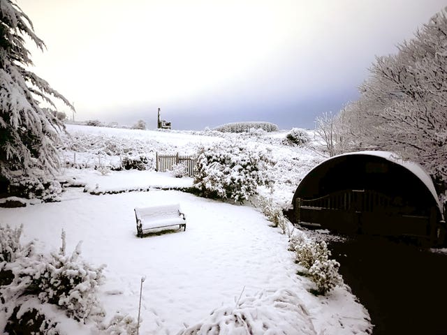 A snowy scene at Lower Ninnis St Day, Redruth, Cornwall, looking west towards St Aubyn (Viv Robinson/PA)
Motorists have been urged to take care on the roads due to difficult driving conditions, with “blustery” and “often wintry” showers expected across northern and western coasts.
A major incident was declared in Somerset after a double-decker bus overturned in a crash involving a motorcycle at around 6am.
The A39 Quantock Road in Bridgwater, was closed with police, fire and ambulance units remaining on the scene into the afternoon.
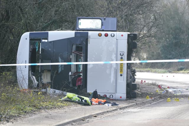 The scene on the A39 Quantock Road in Bridgwater after a double-decker bus overturned in a crash involving a motorcycle (Andrew Matthews/PA)
NHS Somerset said 27 patients were taken to a minor injuries unit while another 26 were taken to the emergency department at Musgrove Hospital for injuries consistent with a “serious traffic collision”.
A “small number” of those injured were left needing surgery, the service said.
 The coldest UK January temperatures (PA Graphics)
The RAC said there had been a “huge spike” in breakdowns on Tuesday due to icy conditions.
A spokesperson said: “Even though the weather is largely dry in most places, today is proving far busier than yesterday, which is unusual as Monday is generally the biggest day for breakdowns.
“Flat batteries are the top reason for drivers calling us out as cars with older ones finally give up the ghost in the cold.
READ MORE: Essential tips on how to drive safely on Scotland's icy roads
“Ice, and in some areas snow, are the biggest risks for drivers this week – particularly on stretches of road that haven’t been treated.
“It’s vital everyone slows down and gives themselves time to plenty of time to brake and react in the event something unexpected happens.”
 The sun rises behind The Royal Liver Building in Liverpool (Peter Byrne/PA)
The Met Office said it expects milder air to start moving in from Friday afternoon in Northern Ireland and Scotland.
Spokesman Oli Claydon said: “That will slowly spread across the rest of the UK. South-east England will hold onto colder temperatures for longer.”
The Met Office recorded the coldest night of last year on the night of December 12-13 when temperatures plunged to minus 15.7C in Braemer, Aberdeenshire, during a cold snap.


Why are you making commenting on The Herald only available to subscribers?
It should have been a safe space for informed debate, somewhere for readers to discuss issues around the biggest stories of the day, but all too often the below the line comments on most websites have become bogged down by off-topic discussions and abuse.
heraldscotland.com is tackling this problem by allowing only subscribers to comment.
We are doing this to improve the experience for our loyal readers and we believe it will reduce the ability of trolls and troublemakers, who occasionally find their way onto our site, to abuse our journalists and readers. We also hope it will help the comments section fulfil its promise as a part of Scotland's conversation with itself.
We are lucky at The Herald. We are read by an informed, educated readership who can add their knowledge and insights to our stories.
That is invaluable.
We are making the subscriber-only change to support our valued readers, who tell us they don't want the site cluttered up with irrelevant comments, untruths and abuse.
In the past, the journalist’s job was to collect and distribute information to the audience. Technology means that readers can shape a discussion. We look forward to hearing from you on heraldscotland.com
Comments & Moderation
Readers’ comments: You are personally liable for the content of any comments you upload to this website, so please act responsibly. We do not pre-moderate or monitor readers’ comments appearing on our websites, but we do post-moderate in response to complaints we receive or otherwise when a potential problem comes to our attention. You can make a complaint by using the ‘report this post’ link . We may then apply our discretion under the user terms to amend or delete comments.
Post moderation is undertaken full-time 9am-6pm on weekdays, and on a part-time basis outwith those hours.
Read the rules here